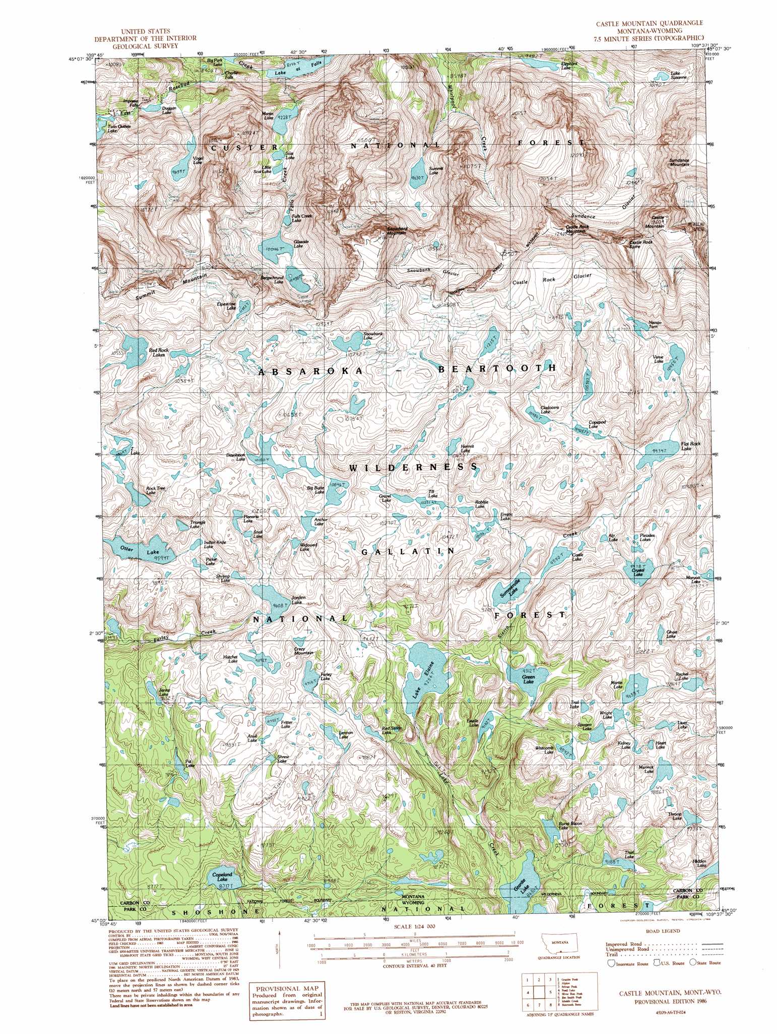
Castle Mountain Topo Map Montana
To zoom in, hover over the map of Castle Mountain
USGS Topo Quad 45109a6 - 1:24,000 scale
| Topo Map Name: | Castle Mountain |
| USGS Topo Quad ID: | 45109a6 |
| Print Size: | ca. 21 1/4" wide x 27" high |
| Southeast Coordinates: | 45° N latitude / 109.625° W longitude |
| Map Center Coordinates: | 45.0625° N latitude / 109.6875° W longitude |
| U.S. States: | MT, WY |
| Filename: | o45109a6.jpg |
| Download Map JPG Image: | Castle Mountain topo map 1:24,000 scale |
| Map Type: | Topographic |
| Topo Series: | 7.5´ |
| Map Scale: | 1:24,000 |
| Source of Map Images: | United States Geological Survey (USGS) |
| Alternate Map Versions: |
Castle Mountain MT 1986, updated 1986 Download PDF Buy paper map Castle Mountain MT 1986, updated 1986 Download PDF Buy paper map Castle Mountain MT 1991, updated 1997 Download PDF Buy paper map Castle Mountain MT 2011 Download PDF Buy paper map Castle Mountain MT 2014 Download PDF Buy paper map |
| FStopo: | US Forest Service topo Castle Mountain is available: Download FStopo PDF Download FStopo TIF |
1:24,000 Topo Quads surrounding Castle Mountain
Cathedral Point |
Mount Wood |
Emerald Lake |
Mackay Ranch |
Roscoe |
Little Park Mountain |
Granite Peak |
Alpine |
Sylvan Peak |
Bare Mountain |
Cooke City |
Fossil Lake |
Castle Mountain |
Silver Run Peak |
Black Pyramid Mountain |
Pilot Peak |
Jim Smith Peak |
Muddy Creek |
Beartooth Butte |
Deep Lake |
Canoe Lake |
Hurricane Mesa |
Hunter Peak |
Windy Mountain |
Dillworth Bench |
> Back to 45109a1 at 1:100,000 scale
> Back to 45108a1 at 1:250,000 scale
> Back to U.S. Topo Maps home
Castle Mountain topo map: Gazetteer
Castle Mountain: Falls
Charlie Falls elevation 2574m 8444′Impasse Falls elevation 2746m 9009′
Castle Mountain: Glaciers
Castle Rock Glacier elevation 3495m 11466′Snowbank Glacier elevation 3329m 10921′
Sundance Glacier elevation 3288m 10787′
Castle Mountain: Lakes
Alp Lake elevation 2978m 9770′Anchor Lake elevation 3056m 10026′
Anvil Lake elevation 2959m 9708′
Bergschrund Lake elevation 3085m 10121′
Big Butte Lake elevation 3077m 10095′
Big Park Lake elevation 2519m 8264′
Burnt Bacon Lake elevation 2729m 8953′
Castle Lake elevation 2908m 9540′
Cladocera Lake elevation 3199m 10495′
Copeland Lake elevation 2656m 8713′
Copepod Lake elevation 3176m 10419′
Crystal Lake elevation 3010m 9875′
Desolation Lake elevation 3105m 10187′
Duggan Lake elevation 2684m 8805′
Elephant Lake elevation 2895m 9498′
Elpestrine Lake elevation 3334m 10938′
Erratic Lake elevation 3120m 10236′
Estelle Lake elevation 2800m 9186′
Falls Creek Lake elevation 3033m 9950′
Farley Lake elevation 2955m 9694′
Flat Rock Lake elevation 3031m 9944′
Fritter Lake elevation 2960m 9711′
Ghost Lake elevation 3070m 10072′
Glissade Lake elevation 3065m 10055′
Granite Lake elevation 2634m 8641′
Gravel Lake elevation 3131m 10272′
Green Lake elevation 2841m 9320′
Hatchet Lake elevation 3016m 9895′
Heart Lake elevation 3030m 9940′
Hermit Lake elevation 3241m 10633′
Hidden Lake elevation 2886m 9468′
Indian Knife Lake elevation 2958m 9704′
Jenny Lake elevation 2859m 9379′
Jorden Lake elevation 2934m 9625′
Kidney Lake elevation 3010m 9875′
Lake at Falls elevation 2479m 8133′
Lake Elaine elevation 2824m 9265′
Lake Susanne elevation 3093m 10147′
Lennon Lake elevation 2944m 9658′
Little Scat Lake elevation 2839m 9314′
Liver Lake elevation 3007m 9865′
Martin Lake elevation 2944m 9658′
Martin Lake elevation 2813m 9229′
Maryott Lake elevation 3176m 10419′
Navajo Tarn elevation 3273m 10738′
North Hidden Lake elevation 3019m 9904′
Otter Lake elevation 2923m 9589′
Pat Lake elevation 2803m 9196′
Picket Lake elevation 2960m 9711′
Planaria Lake elevation 3053m 10016′
Pleiades Lakes elevation 3013m 9885′
Rachel Lake elevation 3005m 9858′
Red Rock Lakes elevation 3213m 10541′
Red Storm Lake elevation 2899m 9511′
Robble Lake elevation 3093m 10147′
Rock Tree Lake elevation 2987m 9799′
Scat Lake elevation 2838m 9311′
Shrew Lake elevation 2915m 9563′
Shrimp Lake elevation 2957m 9701′
Snail Lake elevation 3045m 9990′
Snowbank Lake elevation 3278m 10754′
Spogen Lake elevation 2921m 9583′
Summerville Lake elevation 2911m 9550′
Summit Lake elevation 2932m 9619′
Thiel Lake elevation 2800m 9186′
Throop Lake elevation 2981m 9780′
Till Lake elevation 3130m 10269′
Trail Lake elevation 2974m 9757′
Triangle Lake elevation 2981m 9780′
Varve Lake elevation 3190m 10465′
Vogel Lake elevation 2947m 9668′
Whitcomb Lake elevation 2911m 9550′
Widowed Lake elevation 3045m 9990′
Wright Lake elevation 2936m 9632′
Z Lake elevation 2996m 9829′
Castle Mountain: Pillars
Castle Rock Spire elevation 3822m 12539′Castle Mountain: Streams
Falls Creek elevation 2485m 8152′Granite Creek elevation 2520m 8267′
Lake Creek elevation 2634m 8641′
Sierra Creek elevation 2669m 8756′
Castle Mountain: Summits
Castle Mountain elevation 3842m 12604′Castle Rock Mountain elevation 3785m 12417′
Crazy Mountain elevation 3081m 10108′
Snowbank Mountain elevation 3661m 12011′
Summit Mountain elevation 3511m 11519′
Castle Mountain digital topo map on disk
Buy this Castle Mountain topo map showing relief, roads, GPS coordinates and other geographical features, as a high-resolution digital map file on DVD: