Alpine Topo Map Montana
To zoom in, hover over the map of Alpine
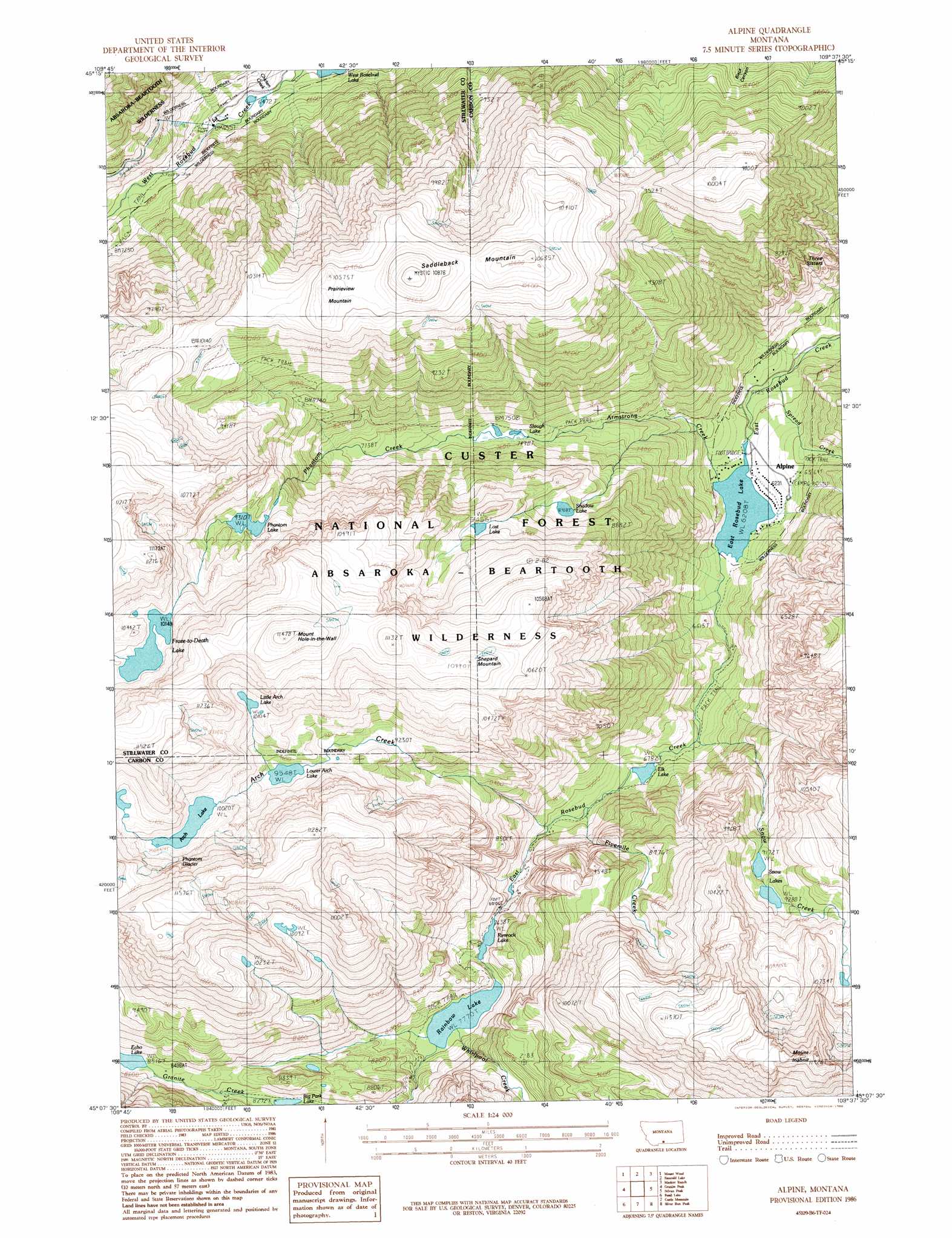
USGS Topo Quad 45109b6 - 1:24,000 scale
| Topo Map Name: | Alpine |
| USGS Topo Quad ID: | 45109b6 |
| Print Size: | ca. 21 1/4" wide x 27" high |
| Southeast Coordinates: | 45.125° N latitude / 109.625° W longitude |
| Map Center Coordinates: | 45.1875° N latitude / 109.6875° W longitude |
| U.S. State: | MT |
| Filename: | o45109b6.jpg |
| Download Map JPG Image: | Alpine topo map 1:24,000 scale |
| Map Type: | Topographic |
| Topo Series: | 7.5´ |
| Map Scale: | 1:24,000 |
| Source of Map Images: | United States Geological Survey (USGS) |
| Alternate Map Versions: |
Alpine MT 1986, updated 1986 Download PDF Buy paper map Alpine MT 1996, updated 1999 Download PDF Buy paper map Alpine MT 2011 Download PDF Buy paper map Alpine MT 2014 Download PDF Buy paper map |
| FStopo: | US Forest Service topo Alpine is available: Download FStopo PDF Download FStopo TIF |
1:24,000 Topo Quads surrounding Alpine
Meyer Mountain |
Nye |
Beehive |
Fishtail |
Roscoe Nw |
Cathedral Point |
Mount Wood |
Emerald Lake |
Mackay Ranch |
Roscoe |
Little Park Mountain |
Granite Peak |
Alpine |
Sylvan Peak |
Bare Mountain |
Cooke City |
Fossil Lake |
Castle Mountain |
Silver Run Peak |
Black Pyramid Mountain |
Pilot Peak |
Jim Smith Peak |
Muddy Creek |
Beartooth Butte |
Deep Lake |
> Back to 45109a1 at 1:100,000 scale
> Back to 45108a1 at 1:250,000 scale
> Back to U.S. Topo Maps home
Alpine topo map: Gazetteer
Alpine: Glaciers
Phantom Glacier elevation 3160m 10367′Alpine: Lakes
Arch Lake elevation 3056m 10026′East Rosebud Lake elevation 1894m 6213′
Echo Lake elevation 2597m 8520′
Elk Lake elevation 2069m 6788′
Froze-to-Death Lake elevation 3095m 10154′
Little Arch Lake elevation 3078m 10098′
Lost Lake elevation 2790m 9153′
Lower Arch Lake elevation 2912m 9553′
Phantom Lake elevation 2839m 9314′
Rainbow Lake elevation 2370m 7775′
Rimrock Lake elevation 2329m 7641′
Shadow Lake elevation 2568m 8425′
Slough Lake elevation 2286m 7500′
Snow Lakes elevation 2832m 9291′
Alpine: Populated Places
Alpine elevation 1898m 6227′Alpine: Post Offices
Alpine Post Office (historical) elevation 1898m 6227′Alpine: Streams
Arch Creek elevation 2121m 6958′Armstrong Creek elevation 1898m 6227′
Chicken Creek elevation 1974m 6476′
Fivemile Creek elevation 2100m 6889′
Phantom Creek elevation 2286m 7500′
Snow Creek elevation 2009m 6591′
Spread Creek elevation 1839m 6033′
Whirlpool Creek elevation 2370m 7775′
Alpine: Summits
Mount Hole-in-the-Wall elevation 3490m 11450′Mount Inabnit elevation 3613m 11853′
Prairieview Mountain elevation 3223m 10574′
Saddleback Mountain elevation 3314m 10872′
Shepard Mountain elevation 3339m 10954′
Three Sisters elevation 2501m 8205′
Alpine digital topo map on disk
Buy this Alpine topo map showing relief, roads, GPS coordinates and other geographical features, as a high-resolution digital map file on DVD: