Nye Topo Map Montana
To zoom in, hover over the map of Nye
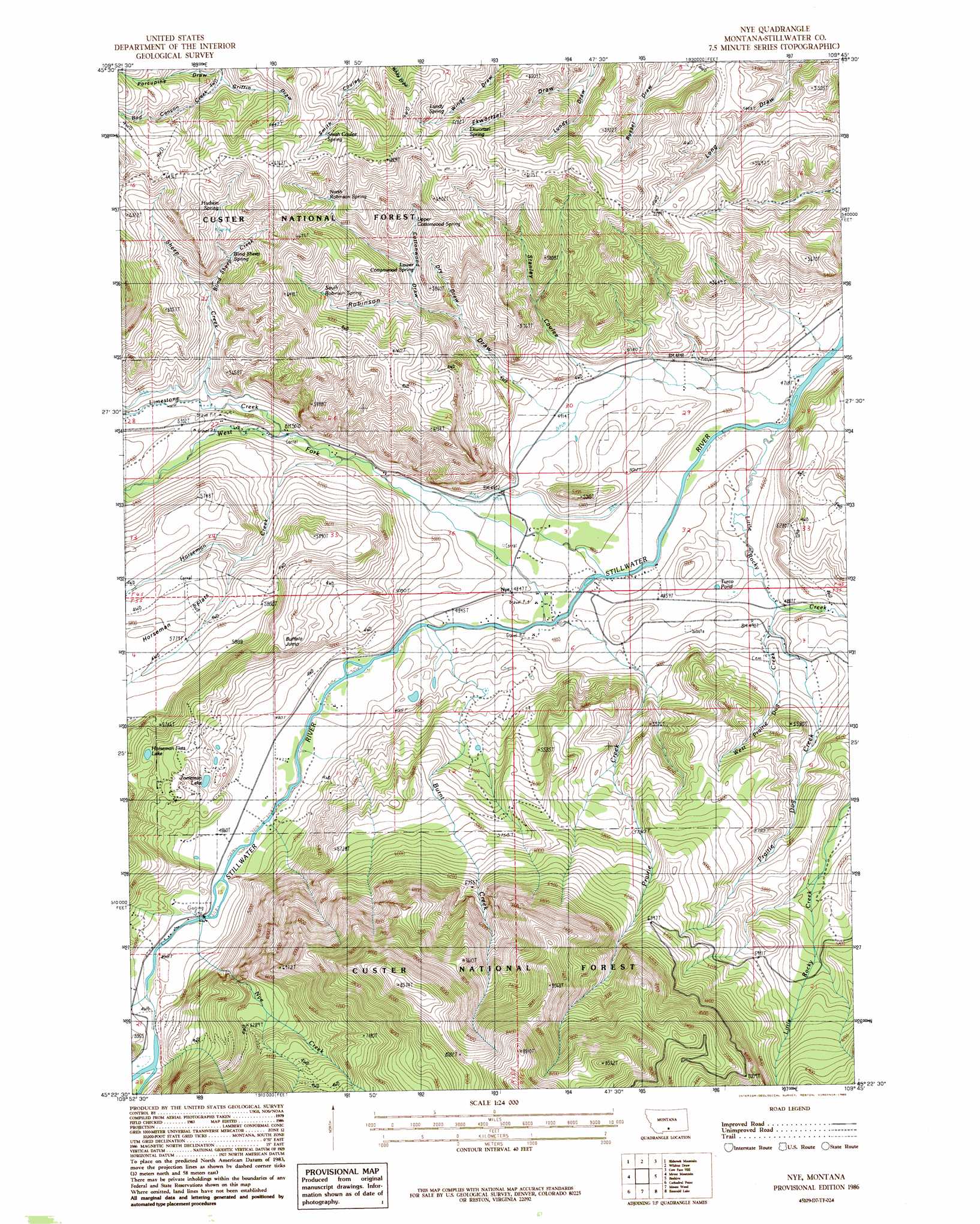
USGS Topo Quad 45109d7 - 1:24,000 scale
| Topo Map Name: | Nye |
| USGS Topo Quad ID: | 45109d7 |
| Print Size: | ca. 21 1/4" wide x 27" high |
| Southeast Coordinates: | 45.375° N latitude / 109.75° W longitude |
| Map Center Coordinates: | 45.4375° N latitude / 109.8125° W longitude |
| U.S. State: | MT |
| Filename: | o45109d7.jpg |
| Download Map JPG Image: | Nye topo map 1:24,000 scale |
| Map Type: | Topographic |
| Topo Series: | 7.5´ |
| Map Scale: | 1:24,000 |
| Source of Map Images: | United States Geological Survey (USGS) |
| Alternate Map Versions: |
Nye MT 1986, updated 1986 Download PDF Buy paper map Nye MT 1996, updated 1999 Download PDF Buy paper map Nye MT 2011 Download PDF Buy paper map Nye MT 2014 Download PDF Buy paper map |
| FStopo: | US Forest Service topo Nye is available: Download FStopo PDF Download FStopo TIF |
1:24,000 Topo Quads surrounding Nye
Mcleod |
Ross Canyon |
Packsaddle Butte |
Work Creek |
Reed Point |
Squaw Peak |
Sliderock Mountain |
Wildcat Draw |
Cow Face Hill |
Sandborn Creek |
Picket Pin Mountain |
Meyer Mountain |
Nye |
Beehive |
Fishtail |
Tumble Mountain |
Cathedral Point |
Mount Wood |
Emerald Lake |
Mackay Ranch |
Pinnacle Mountain |
Little Park Mountain |
Granite Peak |
Alpine |
Sylvan Peak |
> Back to 45109a1 at 1:100,000 scale
> Back to 45108a1 at 1:250,000 scale
> Back to U.S. Topo Maps home
Nye topo map: Gazetteer
Nye: Bridges
Stillwater River Bridge elevation 1464m 4803′Nye: Cliffs
Buffalo Jump elevation 1651m 5416′Nye: Lakes
Horseman Flats Lake elevation 1668m 5472′Turco Pond elevation 1476m 4842′
Zoeteman Lake elevation 1537m 5042′
Nye: Mines
Benbow Millsite elevation 1826m 5990′Tandy 6 Coal Mine elevation 1523m 4996′
Nye: Populated Places
Nye elevation 1479m 4852′Nye: Post Offices
Nye Post Office (historical) elevation 1479m 4852′Nye: Springs
04S15E34DCAC01 Spring elevation 1687m 5534′05S15E02AABA01 Spring elevation 1567m 5141′
05S15E02ACDB01 Spring elevation 1513m 4963′
05S15E02BBAC01 Spring elevation 1657m 5436′
Blind Sheep Spring elevation 1780m 5839′
Ekwortzel Spring elevation 1863m 6112′
Hudson Spring elevation 1874m 6148′
Lower Cottonwood Spring elevation 1730m 5675′
Lundy Spring elevation 1881m 6171′
North Robinson Spring elevation 1862m 6108′
Smith Coulee Spring elevation 1938m 6358′
South Robinson Spring elevation 1803m 5915′
Upper Cottonwood Spring elevation 1790m 5872′
Nye: Streams
Blind Sheep Creek elevation 1690m 5544′Burnt Creek elevation 1470m 4822′
Horseman Creek elevation 1533m 5029′
Limestone Creek elevation 1543m 5062′
Little Rocky Creek elevation 1438m 4717′
Magpie Creek elevation 1434m 4704′
Nye Creek elevation 1491m 4891′
Prairie Creek elevation 1464m 4803′
Prairie Dog Creek elevation 1485m 4872′
Sheep Creek elevation 1584m 5196′
West Fork Stillwater River elevation 1461m 4793′
West Prairie Dog Creek elevation 1500m 4921′
Nye: Valleys
Cottonwood Draw elevation 1690m 5544′Ekwortzel Draw elevation 1657m 5436′
Griffin Draw elevation 1812m 5944′
Porcupine Draw elevation 1811m 5941′
Robinson Draw elevation 1497m 4911′
Stanley Coulee elevation 1511m 4957′
Nye: Wells
04S15E25AABA01 Well elevation 1568m 5144′04S15E27DAAC01 Well elevation 1557m 5108′
04S16E28BADB01 Well elevation 1446m 4744′
04S16E29BADA01 Well elevation 1470m 4822′
04S16E29BADA02 Well elevation 1470m 4822′
04S16E29BADA03 Well elevation 1470m 4822′
04S16E29BBAC01 Well elevation 1497m 4911′
04S16E29BCDA01 Well elevation 1488m 4881′
04S16E30BDCD01 Well elevation 1501m 4924′
04S16E30CCDD01 Well elevation 1496m 4908′
04S16E30DBDB01 Well elevation 1489m 4885′
04S16E31DDDB01 Well elevation 1459m 4786′
05S15E01AAAA01 Well elevation 1476m 4842′
05S15E02DCCB01 Well elevation 1477m 4845′
05S15E10DADA01 Well elevation 1480m 4855′
05S15E15CACD01 Well elevation 1491m 4891′
05S15E15CCBB01 Well elevation 1501m 4924′
05S15E21AADD01 Well elevation 1499m 4917′
05S15E21ADDD01 Well elevation 1501m 4924′
05S15E22BBBB01 Well elevation 1506m 4940′
05S16E06BAAB01 Well elevation 1469m 4819′
Nye digital topo map on disk
Buy this Nye topo map showing relief, roads, GPS coordinates and other geographical features, as a high-resolution digital map file on DVD: