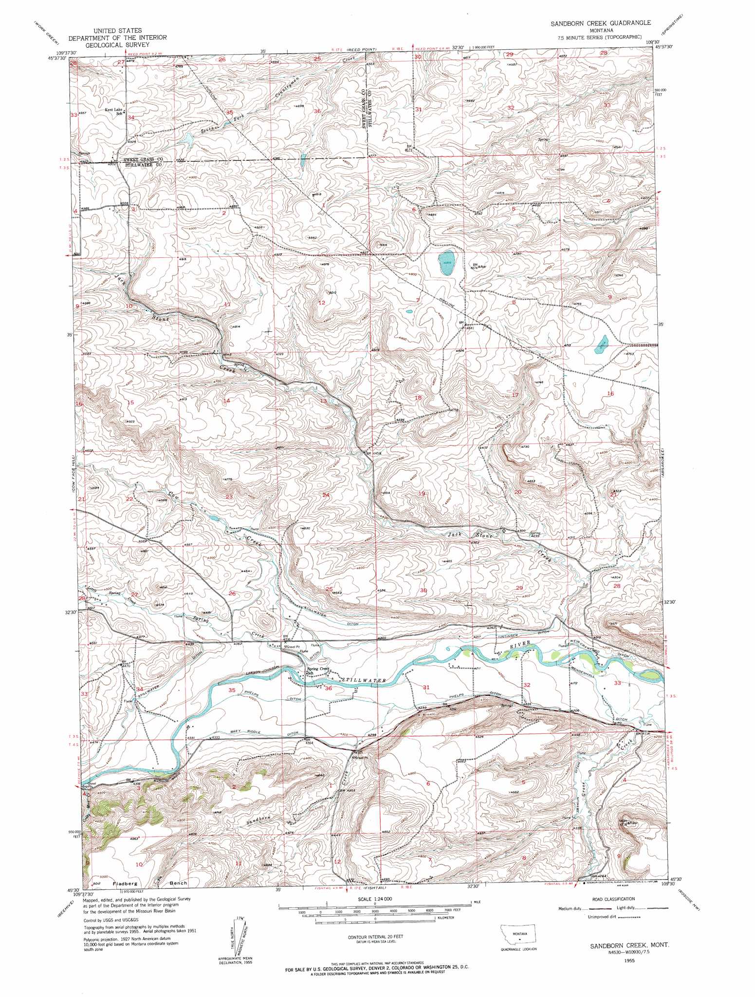
Sandborn Creek Topo Map Montana
To zoom in, hover over the map of Sandborn Creek
USGS Topo Quad 45109e5 - 1:24,000 scale
| Topo Map Name: | Sandborn Creek |
| USGS Topo Quad ID: | 45109e5 |
| Print Size: | ca. 21 1/4" wide x 27" high |
| Southeast Coordinates: | 45.5° N latitude / 109.5° W longitude |
| Map Center Coordinates: | 45.5625° N latitude / 109.5625° W longitude |
| U.S. State: | MT |
| Filename: | o45109e5.jpg |
| Download Map JPG Image: | Sandborn Creek topo map 1:24,000 scale |
| Map Type: | Topographic |
| Topo Series: | 7.5´ |
| Map Scale: | 1:24,000 |
| Source of Map Images: | United States Geological Survey (USGS) |
| Alternate Map Versions: |
Sandborn Creek MT 1955, updated 1957 Download PDF Buy paper map Sandborn Creek MT 1955, updated 1985 Download PDF Buy paper map Sandborn Creek MT 2011 Download PDF Buy paper map Sandborn Creek MT 2014 Download PDF Buy paper map |
1:24,000 Topo Quads surrounding Sandborn Creek
Greycliff |
Lone Indian Butte |
Stephens Hill |
Antelope Point |
Lindemulder Hill |
Packsaddle Butte |
Work Creek |
Reed Point |
Springtime |
Columbus West |
Wildcat Draw |
Cow Face Hill |
Sandborn Creek |
Absarokee |
Whitebird School |
Nye |
Beehive |
Fishtail |
Roscoe Nw |
Roscoe Ne |
Mount Wood |
Emerald Lake |
Mackay Ranch |
Roscoe |
Castagne |
> Back to 45109e1 at 1:100,000 scale
> Back to 45108a1 at 1:250,000 scale
> Back to U.S. Topo Maps home
Sandborn Creek topo map: Gazetteer
Sandborn Creek: Canals
Arthun Ditch elevation 1293m 4242′Brey Riddle Ditch elevation 1317m 4320′
Larson-Johnson Ditch elevation 1311m 4301′
Phelps Ditch elevation 1299m 4261′
Stillwater Ditch elevation 1347m 4419′
Tintinger Ditch elevation 1285m 4215′
Weir-Crawford Ditch elevation 1270m 4166′
Sandborn Creek: Dams
Rosann Rosanna Dana Dam elevation 1464m 4803′Sandborn Creek: Post Offices
Kiehl Post Office (historical) elevation 1383m 4537′Sandborn Creek: Streams
Cow Creek elevation 1299m 4261′Jack Stone Creek elevation 1268m 4160′
Little Spring Creek elevation 1358m 4455′
Sandborn Creek elevation 1298m 4258′
Spring Creek elevation 1299m 4261′
Sandborn Creek: Summits
Madison Grade elevation 1350m 4429′Sandborn Creek: Wells
03S18E33BDAB01 Well elevation 1263m 4143′Sandborn Creek digital topo map on disk
Buy this Sandborn Creek topo map showing relief, roads, GPS coordinates and other geographical features, as a high-resolution digital map file on DVD: