Otter Creek School Topo Map Montana
To zoom in, hover over the map of Otter Creek School
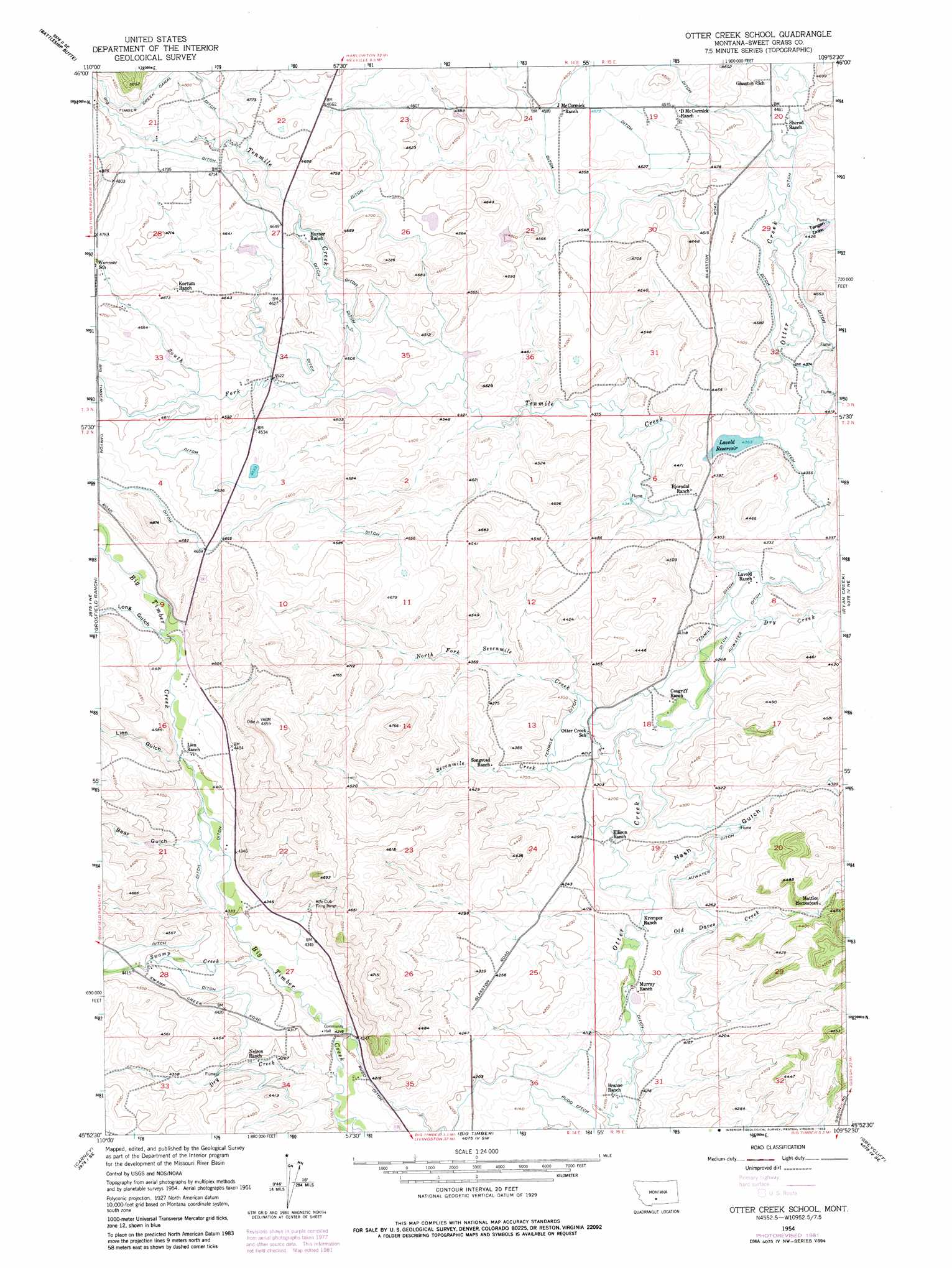
USGS Topo Quad 45109h8 - 1:24,000 scale
| Topo Map Name: | Otter Creek School |
| USGS Topo Quad ID: | 45109h8 |
| Print Size: | ca. 21 1/4" wide x 27" high |
| Southeast Coordinates: | 45.875° N latitude / 109.875° W longitude |
| Map Center Coordinates: | 45.9375° N latitude / 109.9375° W longitude |
| U.S. State: | MT |
| Filename: | o45109h8.jpg |
| Download Map JPG Image: | Otter Creek School topo map 1:24,000 scale |
| Map Type: | Topographic |
| Topo Series: | 7.5´ |
| Map Scale: | 1:24,000 |
| Source of Map Images: | United States Geological Survey (USGS) |
| Alternate Map Versions: |
Otter Creek School MT 1954, updated 1957 Download PDF Buy paper map Otter Creek School MT 1954, updated 1976 Download PDF Buy paper map Otter Creek School MT 1954, updated 1982 Download PDF Buy paper map Otter Creek School MT 2011 Download PDF Buy paper map Otter Creek School MT 2014 Download PDF Buy paper map |
1:24,000 Topo Quads surrounding Otter Creek School
Rein Lake |
Porcupine Butte |
Melville Nw |
Gougley Creek |
Jim Creek |
Amelong Creek |
Battleship Butte |
Melville |
Upper Glaston Lake |
Gibson Sw |
Raspberry Butte |
Grosfield Ranch |
Otter Creek School |
Ryan Creek |
Sourdough School |
Kelly Hills |
Carney |
Big Timber |
Greycliff |
Lone Indian Butte |
Springdale |
Mcleod |
Ross Canyon |
Packsaddle Butte |
Work Creek |
> Back to 45109e1 at 1:100,000 scale
> Back to 45108a1 at 1:250,000 scale
> Back to U.S. Topo Maps home
Otter Creek School topo map: Gazetteer
Otter Creek School: Canals
Auwater Ditch elevation 1292m 4238′Big Timber Creek Canal elevation 1476m 4842′
Tenmile Ditch elevation 1305m 4281′
Otter Creek School: Dams
Cain Dam elevation 1377m 4517′Lavold Dam elevation 1331m 4366′
Papez Number 1 Dam elevation 1411m 4629′
Papez Number 2 Dam elevation 1360m 4461′
Smoky Dam elevation 1364m 4475′
Otter Creek School: Reservoirs
Lavold Reservoir elevation 1330m 4363′Otter Creek School: Streams
Dry Creek elevation 1275m 4183′Dry Creek elevation 1298m 4258′
North Fork Sevenmile Creek elevation 1278m 4192′
Old Daves Creek elevation 1257m 4124′
Sevenmile Creek elevation 1280m 4199′
South Fork Tenmile Creek elevation 1351m 4432′
Swamp Creek elevation 1301m 4268′
Tenmile Creek elevation 1300m 4265′
Otter Creek School: Valleys
Bear Gulch elevation 1333m 4373′Lien Gulch elevation 1347m 4419′
Long Gulch elevation 1371m 4498′
Nash Gulch elevation 1263m 4143′
Tangen Draw elevation 1347m 4419′
Otter Creek School: Wells
01N14E15DAAB01 Well elevation 1269m 4163′02N14E15____01 Well elevation 1461m 4793′
02N14E15CBCA01 Well elevation 1368m 4488′
02N14E16____01 Well elevation 1390m 4560′
02N14E22____01 Well elevation 1372m 4501′
02N14E22C___01 Well elevation 1362m 4468′
02N14E34A___01 Well elevation 1296m 4251′
02N15E05D___01 Well elevation 1320m 4330′
02N15E06____01 Well elevation 1330m 4363′
02N15E08CAAC01 Well elevation 1308m 4291′
02N15E18____01 Well elevation 1287m 4222′
03N14E24____01 Well elevation 1398m 4586′
Otter Creek School digital topo map on disk
Buy this Otter Creek School topo map showing relief, roads, GPS coordinates and other geographical features, as a high-resolution digital map file on DVD: