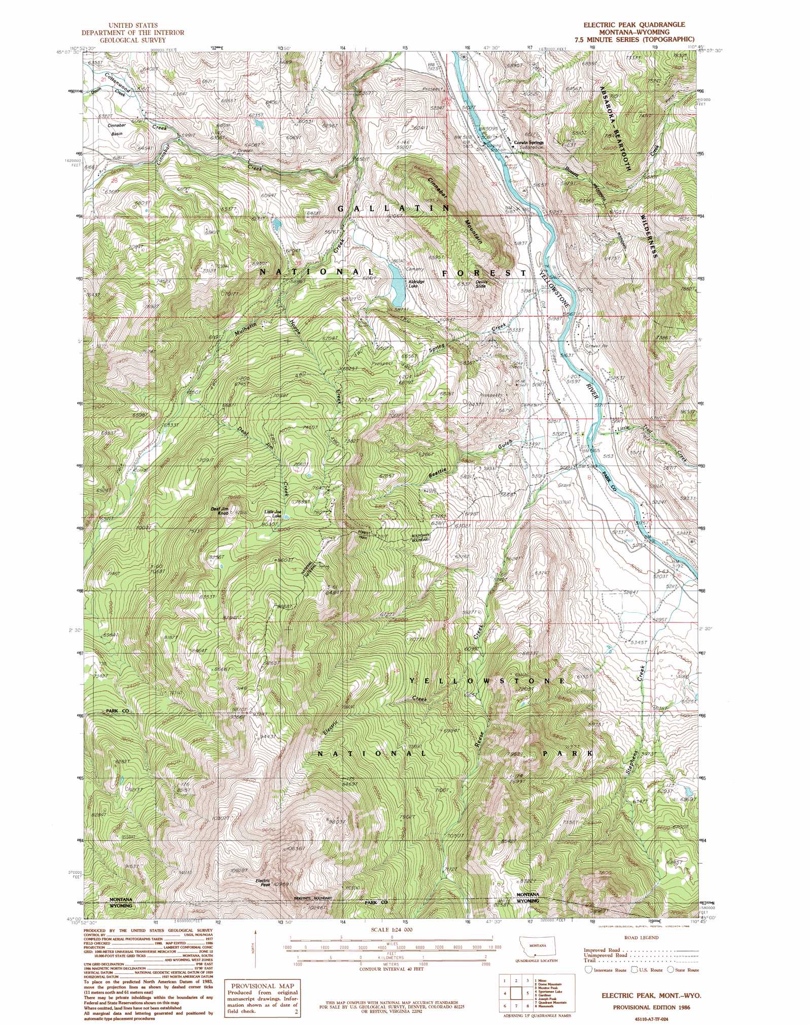
Electric Peak Topo Map Montana
To zoom in, hover over the map of Electric Peak
USGS Topo Quad 45110a7 - 1:24,000 scale
| Topo Map Name: | Electric Peak |
| USGS Topo Quad ID: | 45110a7 |
| Print Size: | ca. 21 1/4" wide x 27" high |
| Southeast Coordinates: | 45° N latitude / 110.75° W longitude |
| Map Center Coordinates: | 45.0625° N latitude / 110.8125° W longitude |
| U.S. States: | MT, WY |
| Filename: | o45110a7.jpg |
| Download Map JPG Image: | Electric Peak topo map 1:24,000 scale |
| Map Type: | Topographic |
| Topo Series: | 7.5´ |
| Map Scale: | 1:24,000 |
| Source of Map Images: | United States Geological Survey (USGS) |
| Alternate Map Versions: |
Electric Peak MT 1986, updated 1986 Download PDF Buy paper map Electric Peak MT 2000, updated 2005 Download PDF Buy paper map Electric Peak MT 2011 Download PDF Buy paper map Electric Peak MT 2014 Download PDF Buy paper map |
| FStopo: | US Forest Service topo Electric Peak is available: Download FStopo PDF Download FStopo TIF |
1:24,000 Topo Quads surrounding Electric Peak
The Sentinel |
Lewis Creek |
Dailey Lake |
Emigrant |
Knowles Peak |
Ramshorn Peak |
Miner |
Dome Mountain |
Monitor Peak |
Mineral Mountain |
Big Horn Peak |
Sportsman Lake |
Electric Peak |
Gardiner |
Ash Mountain |
Divide Lake |
Joseph Peak |
Quadrant Mountain |
Mammoth |
Blacktail Deer Creek |
Richards Creek |
Three Rivers Peak |
Mount Holmes |
Obsidian Cliff |
Cook Peak |
> Back to 45110a1 at 1:100,000 scale
> Back to 45110a1 at 1:250,000 scale
> Back to U.S. Topo Maps home
Electric Peak topo map: Gazetteer
Electric Peak: Basins
Cinnabar Basin elevation 1930m 6332′Electric Peak: Cliffs
Devils Slide elevation 1981m 6499′Electric Peak: Lakes
Aldridge Lake elevation 1791m 5875′Little Joe Lake elevation 2401m 7877′
Electric Peak: Populated Places
Aldridge elevation 1959m 6427′Corwin Springs elevation 1565m 5134′
Electric elevation 1585m 5200′
Electric Peak: Post Offices
Aldridge Post Office (historical) elevation 1959m 6427′Cinnabar Post Office (historical) elevation 1577m 5173′
Corwin Springs Post Office (historical) elevation 1565m 5134′
Electric Post Office (historical) elevation 1585m 5200′
Henderson Post Office (historical) elevation 1704m 5590′
Electric Peak: Springs
LaDuke Spring elevation 1583m 5193′Electric Peak: Streams
Aldridge Creek elevation 1720m 5643′Bassett Creek elevation 1558m 5111′
Cinnabar Creek elevation 1690m 5544′
Cottonwood Creek elevation 1832m 6010′
Deaf Jim Creek elevation 1925m 6315′
Dixon Creek elevation 1878m 6161′
Electric Creek elevation 1828m 5997′
Hoppe Creek elevation 1798m 5898′
Little Trail Creek elevation 1574m 5164′
Reese Creek elevation 1583m 5193′
Reese Creek elevation 1569m 5147′
Spring Creek elevation 1565m 5134′
Stephens Creek elevation 1573m 5160′
Stephens Creek elevation 1573m 5160′
Electric Peak: Summits
Cinnabar Mountain elevation 2167m 7109′Deaf Jim Knob elevation 2486m 8156′
Electric Peak elevation 3341m 10961′
Electric Peak: Valleys
Beattie Gulch elevation 1605m 5265′Electric Peak: Wells
08S08E31DADA01 Well elevation 1581m 5187′08S08E32CCAD01 Well elevation 1576m 5170′
Electric Peak digital topo map on disk
Buy this Electric Peak topo map showing relief, roads, GPS coordinates and other geographical features, as a high-resolution digital map file on DVD: