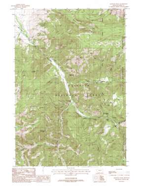
Knowles Peak Topo Map Montana
To zoom in, hover over the map of Knowles Peak
USGS Topo Quad 45110c5 - 1:24,000 scale
| Topo Map Name: | Knowles Peak |
| USGS Topo Quad ID: | 45110c5 |
| Print Size: | ca. 21 1/4" wide x 27" high |
| Southeast Coordinates: | 45.25° N latitude / 110.5° W longitude |
| Map Center Coordinates: | 45.3125° N latitude / 110.5625° W longitude |
| U.S. State: | MT |
| Filename: | o45110c5.jpg |
| Download Map JPG Image: | Knowles Peak topo map 1:24,000 scale |
| Map Type: | Topographic |
| Topo Series: | 7.5´ |
| Map Scale: | 1:24,000 |
| Source of Map Images: | United States Geological Survey (USGS) |
| Alternate Map Versions: |
Knowles Peak MT 1988, updated 1988 Download PDF Buy paper map Knowles Peak MT 1988, updated 1988 Download PDF Buy paper map Knowles Peak MT 1988, updated 1989 Download PDF Buy paper map Knowles Peak MT 2000, updated 2005 Download PDF Buy paper map Knowles Peak MT 2011 Download PDF Buy paper map Knowles Peak MT 2014 Download PDF Buy paper map |
| FStopo: | US Forest Service topo Knowles Peak is available: Download FStopo PDF Download FStopo TIF |
1:24,000 Topo Quads surrounding Knowles Peak
> Back to 45110a1 at 1:100,000 scale
> Back to 45110a1 at 1:250,000 scale
> Back to U.S. Topo Maps home
Knowles Peak topo map: Gazetteer
Knowles Peak: Mines
Alice C Mine elevation 1981m 6499′Barbara Ann Mine elevation 2574m 8444′
Barbara Ann Mine elevation 2545m 8349′
Merlyn Mine elevation 2643m 8671′
NE Section 4 - FS Mine elevation 2612m 8569′
Queen Esther Mine elevation 2625m 8612′
SE Section 23 Mine elevation 2105m 6906′
Knowles Peak: Pillars
Castle Rock elevation 2045m 6709′Knowles Peak: Populated Places
Montanapolis Springs (historical) elevation 1689m 5541′Knowles Peak: Springs
Montanapolis Springs elevation 1813m 5948′Knowles Peak: Streams
Arrastra Creek elevation 1862m 6108′Bulldozer Creek elevation 1738m 5702′
Burnt Creek elevation 1782m 5846′
Counts Creek elevation 1671m 5482′
Davis Creek elevation 1599m 5246′
East Dam Creek elevation 1804m 5918′
East Fork Mill Creek elevation 1682m 5518′
Fire Creek elevation 1910m 6266′
Jomaha Creek elevation 1781m 5843′
Passage Creek elevation 1850m 6069′
Sage Creek elevation 1755m 5757′
Upper Sage Creek elevation 1794m 5885′
West Fork Mill Creek elevation 1712m 5616′
Wicked Creek elevation 1788m 5866′
Knowles Peak: Summits
Arrow Peak elevation 2776m 9107′Green Mountain elevation 2427m 7962′
Knowles Peak elevation 2467m 8093′
Knowles Peak: Trails
Highland Trail elevation 2192m 7191′Knowles Peak digital topo map on disk
Buy this Knowles Peak topo map showing relief, roads, GPS coordinates and other geographical features, as a high-resolution digital map file on DVD:


