Livingston Topo Map Montana
To zoom in, hover over the map of Livingston
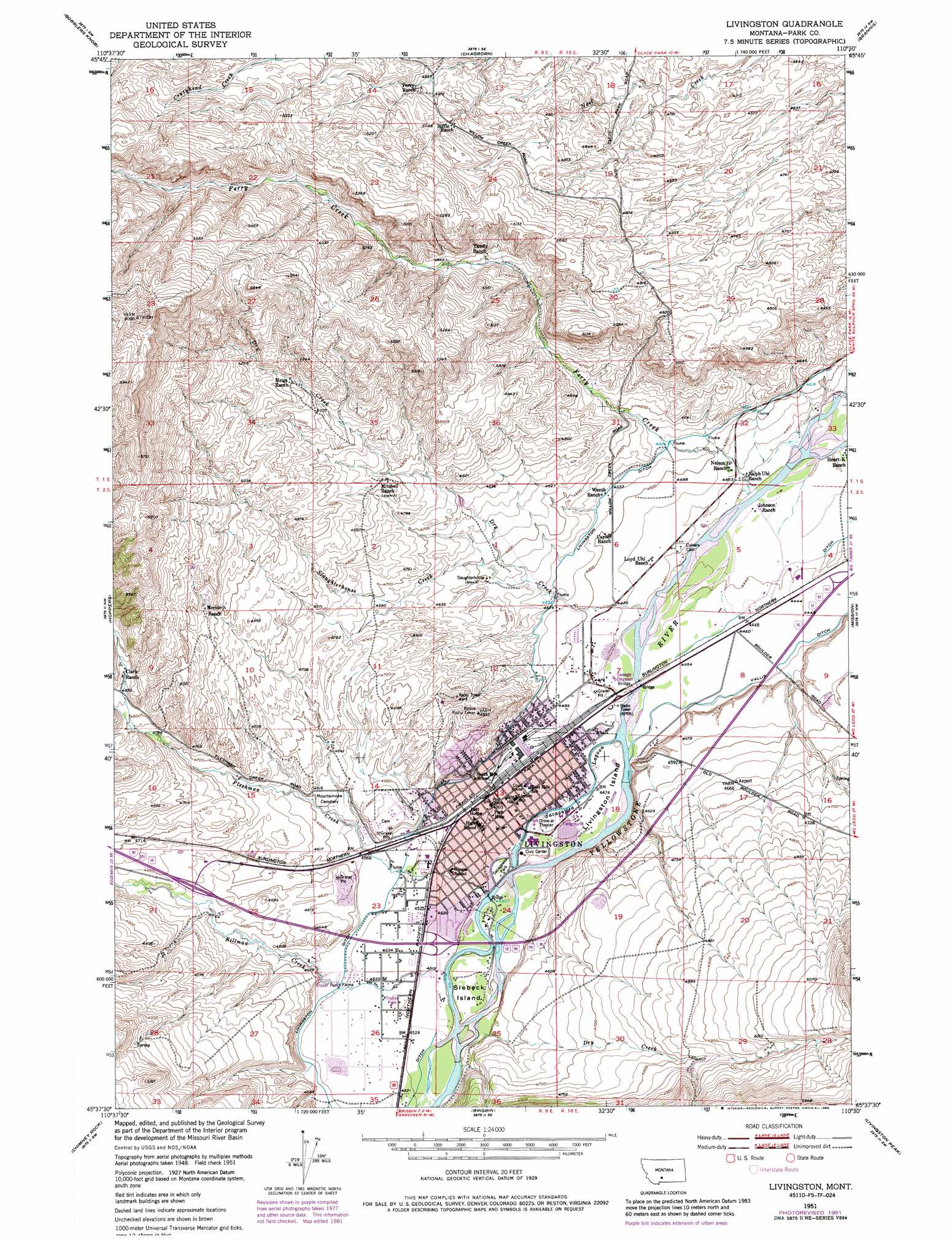
USGS Topo Quad 45110f5 - 1:24,000 scale
| Topo Map Name: | Livingston |
| USGS Topo Quad ID: | 45110f5 |
| Print Size: | ca. 21 1/4" wide x 27" high |
| Southeast Coordinates: | 45.625° N latitude / 110.5° W longitude |
| Map Center Coordinates: | 45.6875° N latitude / 110.5625° W longitude |
| U.S. State: | MT |
| Filename: | o45110f5.jpg |
| Download Map JPG Image: | Livingston topo map 1:24,000 scale |
| Map Type: | Topographic |
| Topo Series: | 7.5´ |
| Map Scale: | 1:24,000 |
| Source of Map Images: | United States Geological Survey (USGS) |
| Alternate Map Versions: |
Livingston MT 1951, updated 1954 Download PDF Buy paper map Livingston MT 1951, updated 1986 Download PDF Buy paper map Livingston MT 1951, updated 1986 Download PDF Buy paper map Livingston MT 2011 Download PDF Buy paper map Livingston MT 2014 Download PDF Buy paper map |
| FStopo: | US Forest Service topo Livingston is available: Download FStopo PDF Download FStopo TIF |
1:24,000 Topo Quads surrounding Livingston
Sedan |
Wilsall |
Clyde Park |
Ibex Mountain |
Fairview Peak |
Grassy Mountain |
Gobblers Knob |
Chadborn |
Grannis |
Hunters Hot Springs |
Bozeman Pass |
Hoppers |
Livingston |
Mission |
Elton |
Bald Knob |
Chimney Rock |
Brisbin |
Livingston Peak |
Mount Rae |
Big Draw |
Pray |
Dexter Point |
Mount Cowen |
West Boulder Plateau |
> Back to 45110e1 at 1:100,000 scale
> Back to 45110a1 at 1:250,000 scale
> Back to U.S. Topo Maps home
Livingston topo map: Gazetteer
Livingston: Airports
Livingston Memorial Hospital Heliport elevation 1377m 4517′Livingston: Bridges
Ferry Creek Bridge elevation 1362m 4468′Harvat Bridge elevation 1361m 4465′
Main Street Bridge elevation 1367m 4484′
Ninth Street Bridge elevation 1370m 4494′
Livingston: Canals
Livingston Ditch elevation 1384m 4540′Livingston: Channels
Sacagawea Lagoon elevation 1366m 4481′Livingston: Crossings
Interchange 330 elevation 1411m 4629′Interchange 333 elevation 1376m 4514′
Interchange 337 elevation 1356m 4448′
Livingston: Islands
Livingston Island elevation 1365m 4478′Siebeck Island elevation 1373m 4504′
Livingston: Lakes
Mud Lake elevation 1376m 4514′Livingston: Parks
G Street Park elevation 1367m 4484′Jack Weimer Memorial Park elevation 1403m 4603′
M Street Park elevation 1368m 4488′
Mars Park elevation 1397m 4583′
Miles Park elevation 1367m 4484′
Ninth Street Park elevation 1372m 4501′
Sacagawea Park elevation 1368m 4488′
Livingston: Populated Places
Bensons Landing (historical) elevation 1359m 4458′Branding Iron Addition elevation 1372m 4501′
Five Acre Tracts/Acreville Addition elevation 1372m 4501′
Geyser Trailer Park elevation 1372m 4501′
Green Acres Addition elevation 1372m 4501′
High Ground Addition elevation 1372m 4501′
Livingston elevation 1372m 4501′
Minnesota Addition elevation 1372m 4501′
Palace Addition elevation 1372m 4501′
Park Addition elevation 1372m 4501′
Park Road Trailer Court elevation 1380m 4527′
Riverside Addition elevation 1372m 4501′
Star Addition elevation 1372m 4501′
Stumps Subdivision elevation 1372m 4501′
Livingston: Post Offices
Bensons Landing Post Office (historical) elevation 1359m 4458′Livingston Post Office elevation 1373m 4504′
Yellowstone Crossing Post Office (historical) elevation 1359m 4458′
Livingston: Streams
Billman Creek elevation 1374m 4507′Dry Creek elevation 1359m 4458′
Dry Creek elevation 1374m 4507′
Ferry Creek elevation 1352m 4435′
Fleshman Creek elevation 1371m 4498′
Slaughterhouse Creek elevation 1390m 4560′
Livingston: Wells
01S10E29A___01 Well elevation 1478m 4849′01S10E32C___01 Well elevation 1375m 4511′
02S09E01D___01 Well elevation 1396m 4580′
02S09E13A___01 Well elevation 1371m 4498′
02S09E13D___01 Well elevation 1368m 4488′
02S09E15A___01 Well elevation 1433m 4701′
02S09E15A___02 Well elevation 1433m 4701′
02S09E23B___01 Well elevation 1410m 4625′
02S09E24C___01 Well elevation 1372m 4501′
02S09E24D___01 Well elevation 1371m 4498′
02S09E26B___01 Well elevation 1384m 4540′
02S10E05D___01 Well elevation 1354m 4442′
02S10E07B___01 Well elevation 1371m 4498′
02S10E07B___02 Well elevation 1371m 4498′
02S10E07C___01 Well elevation 1365m 4478′
02S10E18B___01 Well elevation 1362m 4468′
Livingston digital topo map on disk
Buy this Livingston topo map showing relief, roads, GPS coordinates and other geographical features, as a high-resolution digital map file on DVD: