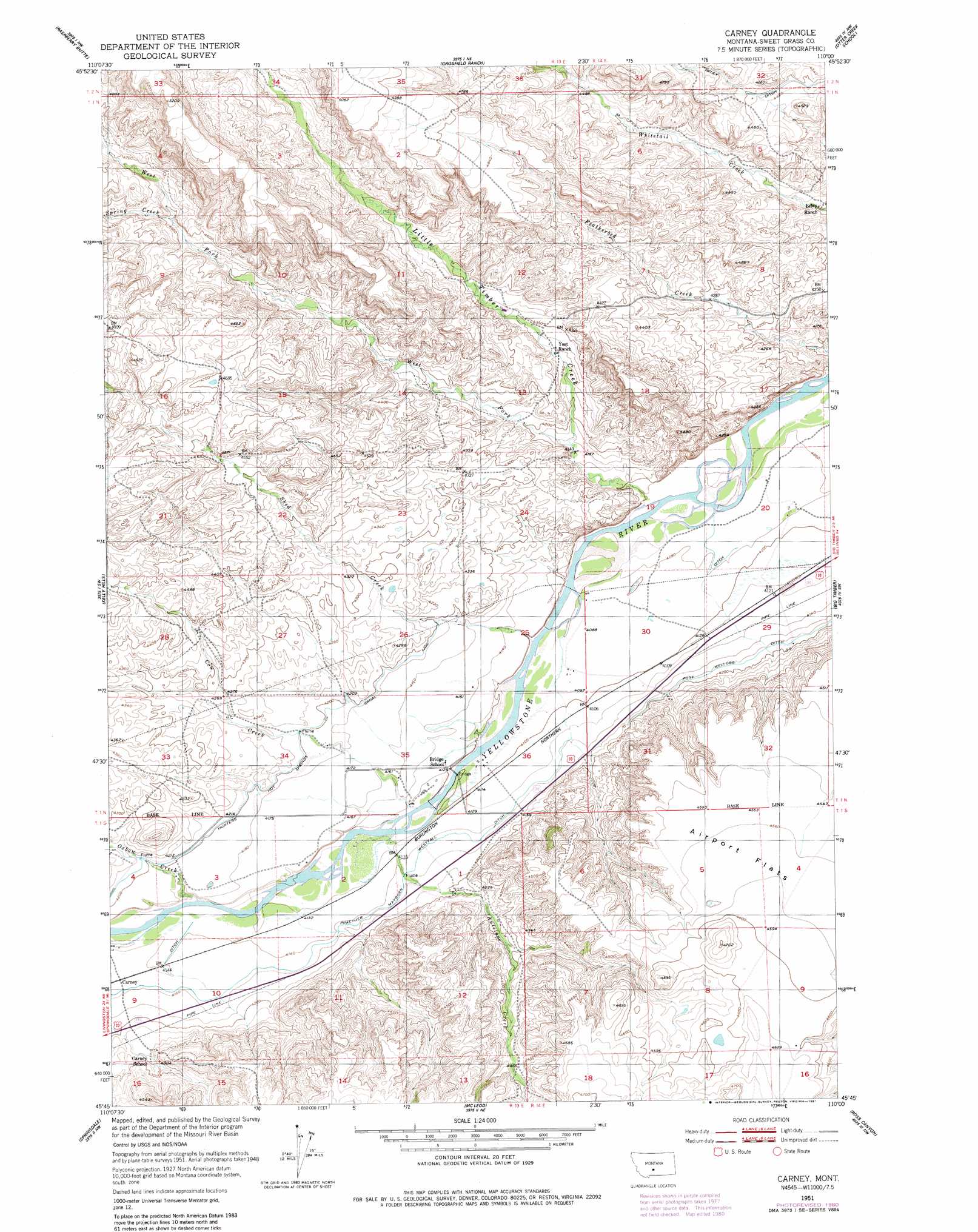
Carney Topo Map Montana
To zoom in, hover over the map of Carney
USGS Topo Quad 45110g1 - 1:24,000 scale
| Topo Map Name: | Carney |
| USGS Topo Quad ID: | 45110g1 |
| Print Size: | ca. 21 1/4" wide x 27" high |
| Southeast Coordinates: | 45.75° N latitude / 110° W longitude |
| Map Center Coordinates: | 45.8125° N latitude / 110.0625° W longitude |
| U.S. State: | MT |
| Filename: | o45110g1.jpg |
| Download Map JPG Image: | Carney topo map 1:24,000 scale |
| Map Type: | Topographic |
| Topo Series: | 7.5´ |
| Map Scale: | 1:24,000 |
| Source of Map Images: | United States Geological Survey (USGS) |
| Alternate Map Versions: |
Carney MT 1951, updated 1953 Download PDF Buy paper map Carney MT 1951, updated 1981 Download PDF Buy paper map Carney MT 2011 Download PDF Buy paper map Carney MT 2014 Download PDF Buy paper map |
1:24,000 Topo Quads surrounding Carney
Crazy Peak |
Amelong Creek |
Battleship Butte |
Melville |
Upper Glaston Lake |
Fairview Peak |
Raspberry Butte |
Grosfield Ranch |
Otter Creek School |
Ryan Creek |
Hunters Hot Springs |
Kelly Hills |
Carney |
Big Timber |
Greycliff |
Elton |
Springdale |
Mcleod |
Ross Canyon |
Packsaddle Butte |
Mount Rae |
Mcleod Basin |
Squaw Peak |
Sliderock Mountain |
Wildcat Draw |
> Back to 45110e1 at 1:100,000 scale
> Back to 45110a1 at 1:250,000 scale
> Back to U.S. Topo Maps home
Carney topo map: Gazetteer
Carney: Bridges
Vogues Bridge elevation 1251m 4104′Carney: Canals
Beley Ditch elevation 1374m 4507′Prather Mayborn Westfall Ditch elevation 1268m 4160′
Carney: Crossings
Interchange 362 elevation 1265m 4150′Carney: Flats
Airport Flats elevation 1387m 4550′Carney: Populated Places
Carney elevation 1266m 4153′Carney: Springs
01N14E31ADBA01 Spring elevation 1308m 4291′01N14E32ABCC01 Spring elevation 1353m 4438′
01S13E12AADD01 Spring elevation 1319m 4327′
Carney: Streams
Antelope Creek elevation 1253m 4110′Cow Creek elevation 1253m 4110′
Dry Creek elevation 1257m 4124′
Little Timber Creek elevation 1243m 4078′
Oxbow Creek elevation 1261m 4137′
Shed Creek elevation 1250m 4101′
Spring Creek elevation 1401m 4596′
West Fork Little Timber Creek elevation 1266m 4153′
Carney: Wells
01N13E25DDBA01 Well elevation 1247m 4091′01N13E36CBAC01 Well elevation 1250m 4101′
01N14E30CBBD01 Well elevation 1247m 4091′
Carney digital topo map on disk
Buy this Carney topo map showing relief, roads, GPS coordinates and other geographical features, as a high-resolution digital map file on DVD: