Sunshine Point Topo Map Montana
To zoom in, hover over the map of Sunshine Point
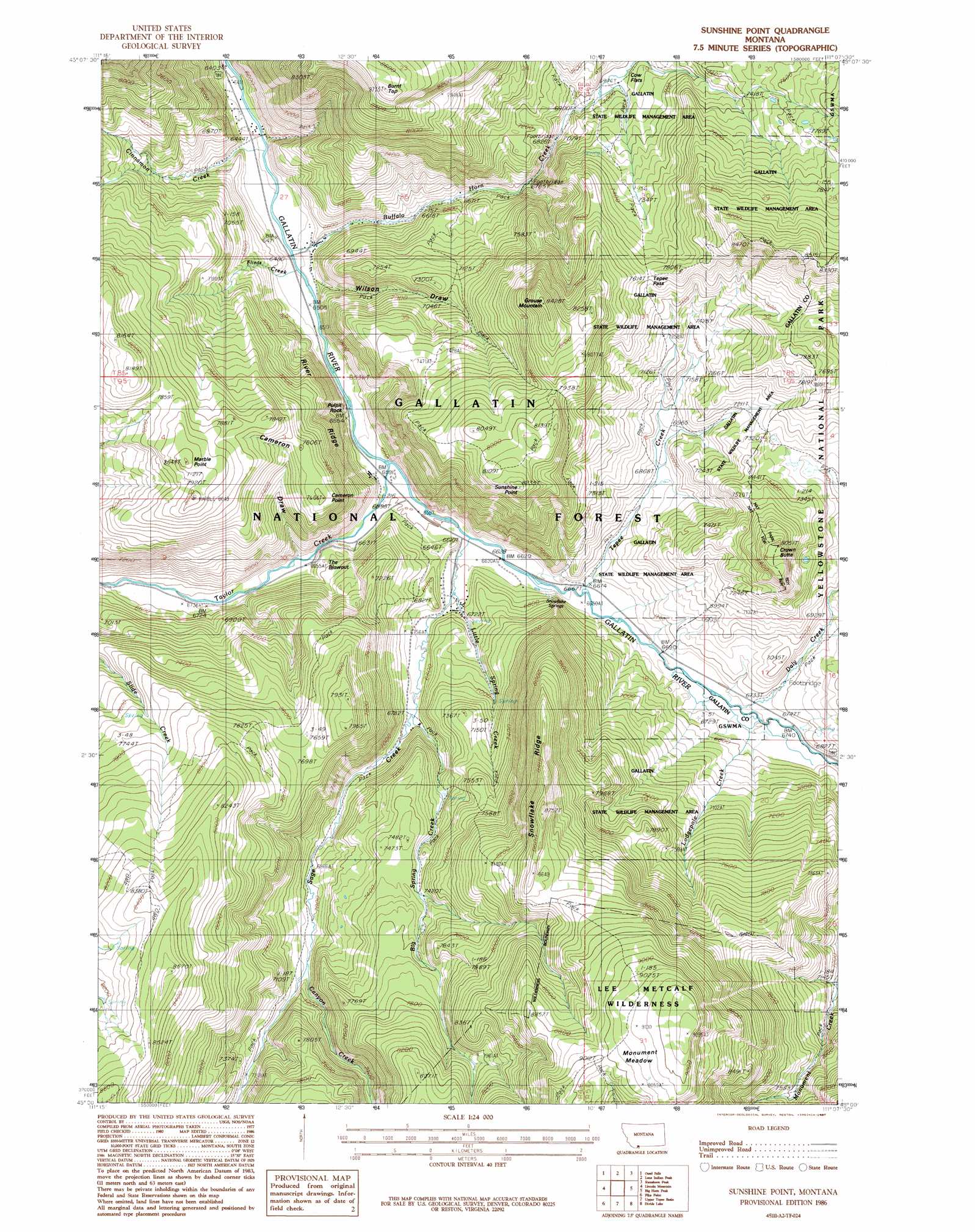
USGS Topo Quad 45111a2 - 1:24,000 scale
| Topo Map Name: | Sunshine Point |
| USGS Topo Quad ID: | 45111a2 |
| Print Size: | ca. 21 1/4" wide x 27" high |
| Southeast Coordinates: | 45° N latitude / 111.125° W longitude |
| Map Center Coordinates: | 45.0625° N latitude / 111.1875° W longitude |
| U.S. State: | MT |
| Filename: | o45111a2.jpg |
| Download Map JPG Image: | Sunshine Point topo map 1:24,000 scale |
| Map Type: | Topographic |
| Topo Series: | 7.5´ |
| Map Scale: | 1:24,000 |
| Source of Map Images: | United States Geological Survey (USGS) |
| Alternate Map Versions: |
Sunshine Point MT 1986, updated 1987 Download PDF Buy paper map Sunshine Point MT 1986, updated 1987 Download PDF Buy paper map Sunshine Point MT 2000, updated 2005 Download PDF Buy paper map Sunshine Point MT 2011 Download PDF Buy paper map Sunshine Point MT 2014 Download PDF Buy paper map |
| FStopo: | US Forest Service topo Sunshine Point is available: Download FStopo PDF Download FStopo TIF |
1:24,000 Topo Quads surrounding Sunshine Point
Lone Mountain |
Gallatin Peak |
Hidden Lake |
The Sentinel |
Lewis Creek |
Sphinx Mountain |
Ousel Falls |
Lone Indian Peak |
Ramshorn Peak |
Miner |
Koch Peak |
Lincoln Mountain |
Sunshine Point |
Big Horn Peak |
Sportsman Lake |
Hilgard Peak |
Pika Point |
Upper Tepee Basin |
Divide Lake |
Joseph Peak |
Earthquake Lake |
Hebgen Dam |
Mount Hebgen |
Richards Creek |
Three Rivers Peak |
> Back to 45111a1 at 1:100,000 scale
> Back to 45110a1 at 1:250,000 scale
> Back to U.S. Topo Maps home
Sunshine Point topo map: Gazetteer
Sunshine Point: Basins
Middle Basin elevation 2026m 6646′The Blowout elevation 2067m 6781′
Sunshine Point: Bridges
Almart Bridge elevation 1958m 6423′Ruegemar Bridge elevation 2033m 6669′
Sam Wilson Bridge elevation 1979m 6492′
Tepee Creek Bridge elevation 2018m 6620′
Sunshine Point: Flats
Cow Flats elevation 2157m 7076′Monument Meadow elevation 2780m 9120′
Sunshine Point: Gaps
Tepee Pass elevation 2326m 7631′Sunshine Point: Parks
Gallatin Game Preserve elevation 2574m 8444′Sunshine Point: Pillars
Pulpit Rock elevation 2097m 6879′Sunshine Point: Populated Places
Eldridge (historical) elevation 1979m 6492′Sunshine Point: Post Offices
Eldridge Post Office (historical) elevation 1979m 6492′Sunshine Point: Ridges
River Ridge elevation 2140m 7020′Snowflake Ridge elevation 2549m 8362′
Sunshine Point: Springs
Snowflake Springs elevation 2034m 6673′Sunshine Point: Streams
Big Spring Creek elevation 2068m 6784′Buffalo Horn Creek elevation 1973m 6473′
Canyon Creek elevation 2148m 7047′
Cinnamon Creek elevation 1959m 6427′
Dailey Creek elevation 2046m 6712′
Flints Creek elevation 1975m 6479′
Little Spring Creek elevation 2033m 6669′
Lodgepole Creek elevation 2047m 6715′
Sage Creek elevation 2016m 6614′
Taylor Creek elevation 2004m 6574′
Tepee Creek elevation 2027m 6650′
Sunshine Point: Summits
Burnt Top elevation 2657m 8717′Cameron Point elevation 2319m 7608′
Crown Butte elevation 2449m 8034′
Grouse Mountain elevation 2563m 8408′
Marble Point elevation 2453m 8047′
Sunshine Point elevation 2502m 8208′
Sunshine Point: Valleys
Cameron Draw elevation 2035m 6676′Wilson Draw elevation 1974m 6476′
Sunshine Point digital topo map on disk
Buy this Sunshine Point topo map showing relief, roads, GPS coordinates and other geographical features, as a high-resolution digital map file on DVD: