Lincoln Mountain Topo Map Montana
To zoom in, hover over the map of Lincoln Mountain
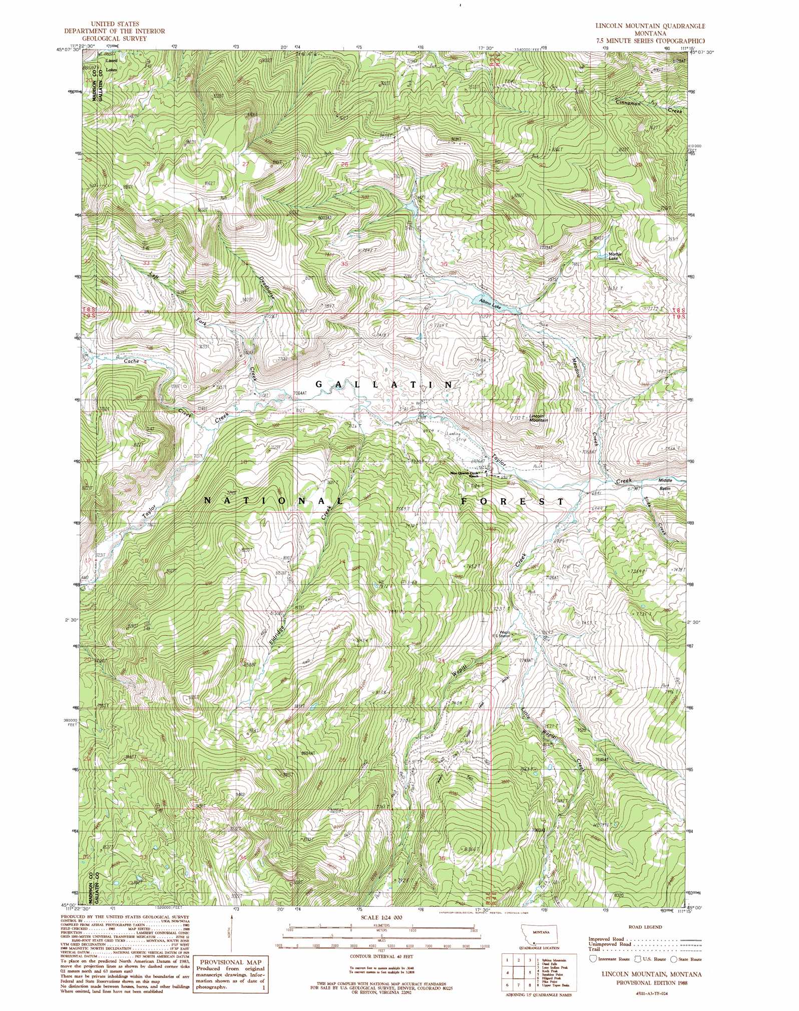
USGS Topo Quad 45111a3 - 1:24,000 scale
| Topo Map Name: | Lincoln Mountain |
| USGS Topo Quad ID: | 45111a3 |
| Print Size: | ca. 21 1/4" wide x 27" high |
| Southeast Coordinates: | 45° N latitude / 111.25° W longitude |
| Map Center Coordinates: | 45.0625° N latitude / 111.3125° W longitude |
| U.S. State: | MT |
| Filename: | o45111a3.jpg |
| Download Map JPG Image: | Lincoln Mountain topo map 1:24,000 scale |
| Map Type: | Topographic |
| Topo Series: | 7.5´ |
| Map Scale: | 1:24,000 |
| Source of Map Images: | United States Geological Survey (USGS) |
| Alternate Map Versions: |
Lincoln Mountain MT 1988, updated 1989 Download PDF Buy paper map Lincoln Mountain MT 2000, updated 2005 Download PDF Buy paper map Lincoln Mountain MT 2011 Download PDF Buy paper map Lincoln Mountain MT 2014 Download PDF Buy paper map |
| FStopo: | US Forest Service topo Lincoln Mountain is available: Download FStopo PDF Download FStopo TIF |
1:24,000 Topo Quads surrounding Lincoln Mountain
Fan Mountain |
Lone Mountain |
Gallatin Peak |
Hidden Lake |
The Sentinel |
Lake Cameron |
Sphinx Mountain |
Ousel Falls |
Lone Indian Peak |
Ramshorn Peak |
No Man Peak |
Koch Peak |
Lincoln Mountain |
Sunshine Point |
Big Horn Peak |
Squaw Creek |
Hilgard Peak |
Pika Point |
Upper Tepee Basin |
Divide Lake |
Cliff Lake |
Earthquake Lake |
Hebgen Dam |
Mount Hebgen |
Richards Creek |
> Back to 45111a1 at 1:100,000 scale
> Back to 45110a1 at 1:250,000 scale
> Back to U.S. Topo Maps home
Lincoln Mountain topo map: Gazetteer
Lincoln Mountain: Airports
Nine Quarter Circle Ranch Airport elevation 2119m 6952′Lincoln Mountain: Dams
Albino Dam elevation 2182m 7158′Lincoln Mountain: Lakes
Albino Lake elevation 2166m 7106′Marble Lake elevation 2289m 7509′
Lincoln Mountain: Mines
Almart/Walton Mine elevation 2340m 7677′Lincoln Mountain: Reservoirs
Meadow Lake elevation 2182m 7158′Lincoln Mountain: Streams
Cache Creek elevation 2166m 7106′Deadhorse Creek elevation 2156m 7073′
Eldridge Creek elevation 2143m 7030′
Left Fork Deadhorse Creek elevation 2239m 7345′
Little Wapiti Creek elevation 2137m 7011′
Meadow Creek elevation 2077m 6814′
Slide Creek elevation 2069m 6788′
Wapiti Creek elevation 2083m 6833′
Lincoln Mountain: Summits
Lincoln Mountain elevation 2347m 7700′Lincoln Mountain: Trails
Eldridge Trail elevation 2468m 8097′Wapiti Ridge Trail elevation 2541m 8336′
Lincoln Mountain digital topo map on disk
Buy this Lincoln Mountain topo map showing relief, roads, GPS coordinates and other geographical features, as a high-resolution digital map file on DVD: