Warm Springs Creek Topo Map Montana
To zoom in, hover over the map of Warm Springs Creek
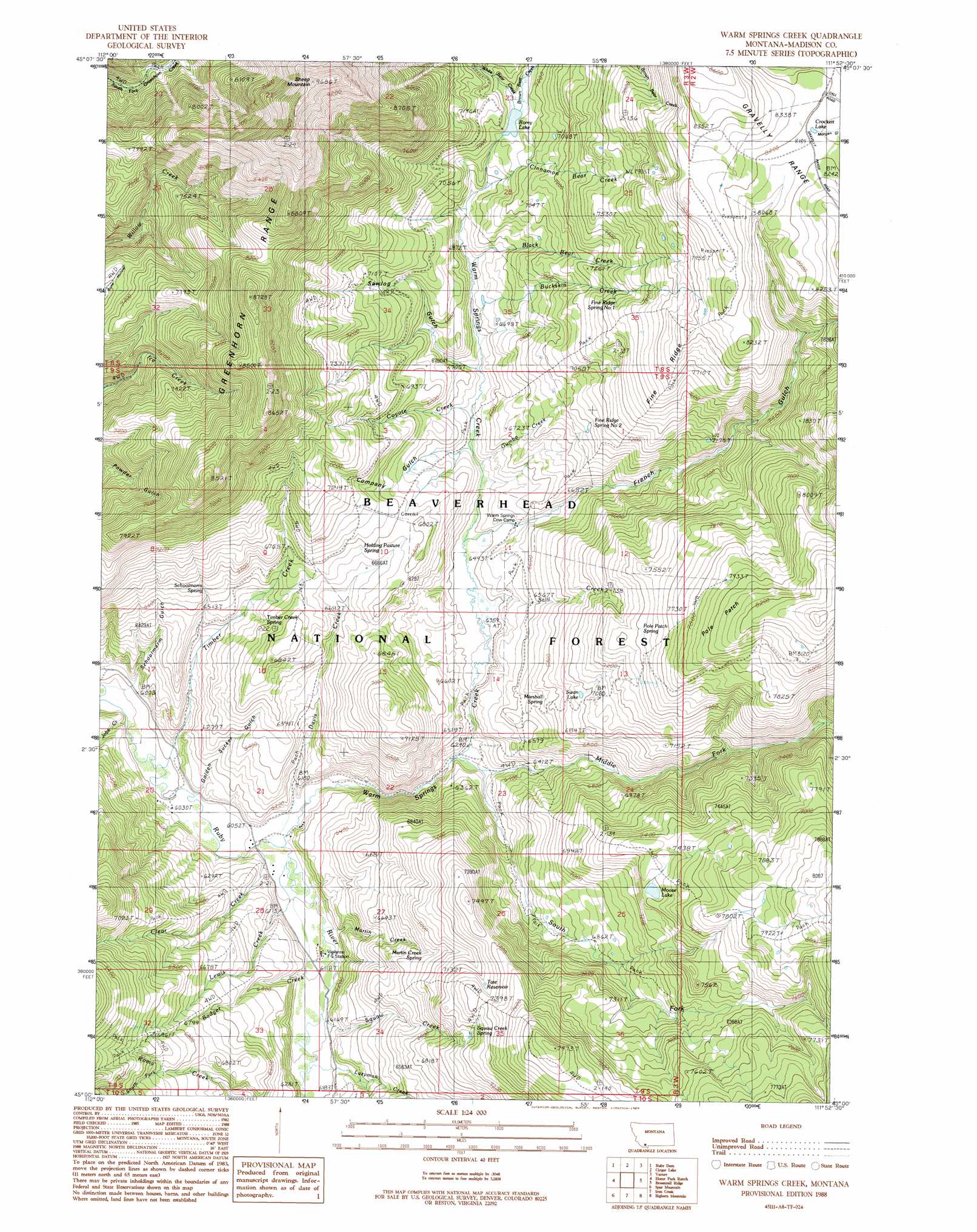
USGS Topo Quad 45111a8 - 1:24,000 scale
| Topo Map Name: | Warm Springs Creek |
| USGS Topo Quad ID: | 45111a8 |
| Print Size: | ca. 21 1/4" wide x 27" high |
| Southeast Coordinates: | 45° N latitude / 111.875° W longitude |
| Map Center Coordinates: | 45.0625° N latitude / 111.9375° W longitude |
| U.S. State: | MT |
| Filename: | o45111a8.jpg |
| Download Map JPG Image: | Warm Springs Creek topo map 1:24,000 scale |
| Map Type: | Topographic |
| Topo Series: | 7.5´ |
| Map Scale: | 1:24,000 |
| Source of Map Images: | United States Geological Survey (USGS) |
| Alternate Map Versions: |
Warm Springs Creek MT 1988, updated 1989 Download PDF Buy paper map Warm Springs Creek MT 1997, updated 2001 Download PDF Buy paper map Warm Springs Creek MT 2011 Download PDF Buy paper map Warm Springs Creek MT 2014 Download PDF Buy paper map |
| FStopo: | US Forest Service topo Warm Springs Creek is available: Download FStopo PDF Download FStopo TIF |
1:24,000 Topo Quads surrounding Warm Springs Creek
Laurin Canyon |
Alder |
Virginia City |
Eightmile Creek |
Ennis |
Metzel Ranch |
Ruby Dam |
Cirque Lake |
Varney |
Cameron |
Belmont Park Ranch |
Home Park Ranch |
Warm Springs Creek |
Broomtail Ridge |
Bucks Nest |
Swamp Creek |
Spur Mountain |
Iron Creek |
Bighorn Mountain |
Granite Mountain |
Antone Peak |
Stonehouse Mountain |
Eureka Basin |
Windy Hill |
Freezeout Mountain |
> Back to 45111a1 at 1:100,000 scale
> Back to 45110a1 at 1:250,000 scale
> Back to U.S. Topo Maps home
Warm Springs Creek topo map: Gazetteer
Warm Springs Creek: Areas
Pole Patch elevation 2468m 8097′Warm Springs Creek: Lakes
Crockett Lake elevation 2494m 8182′Moose Lake elevation 2252m 7388′
Romy Lake elevation 2104m 6902′
Swan Lake elevation 2129m 6984′
Warm Springs Creek: Ranges
Greenhorn Range elevation 2628m 8622′Warm Springs Creek: Reservoirs
Tate Reservoir elevation 2253m 7391′Warm Springs Creek: Ridges
Fine Ridge elevation 2380m 7808′Warm Springs Creek: Springs
Fine Ridge Spring Number 1 elevation 2275m 7463′Fine Ridge Spring Number 2 elevation 2187m 7175′
Holding Pasture Spring elevation 2092m 6863′
Marshall Spring elevation 2070m 6791′
Martin Creek Spring elevation 2074m 6804′
Moltich Spring elevation 2217m 7273′
Pole Patch Spring elevation 2244m 7362′
Schoolmarm Spring elevation 2052m 6732′
Timber Creek Spring elevation 2010m 6594′
Warm Springs Creek: Streams
Badger Creek elevation 1866m 6122′Black Bear Creek elevation 2044m 6706′
Brown Bear Creek elevation 2104m 6902′
Buckskin Creek elevation 2007m 6584′
Cinnamon Bear Creek elevation 2055m 6742′
Clear Creek elevation 1853m 6079′
Coyote Creek elevation 1995m 6545′
Davis Creek elevation 1849m 6066′
Gumbo Creek elevation 1962m 6437′
Jobe Creek elevation 1827m 5994′
Lazyman Creek elevation 1883m 6177′
Lewis Creek elevation 1853m 6079′
Lott Creek elevation 1876m 6154′
Martin Creek elevation 1858m 6095′
Middle Fork Warm Springs Creek elevation 1897m 6223′
South Fork Romy Creek elevation 2085m 6840′
South Fork Warm Springs Creek elevation 1906m 6253′
Still Creek elevation 1940m 6364′
Timber Creek elevation 1825m 5987′
Warm Springs Creek elevation 1850m 6069′
White Bear Creek elevation 2126m 6975′
Warm Springs Creek: Summits
Sheep Mountain elevation 2952m 9685′Warm Springs Creek: Valleys
Company Gulch elevation 1976m 6482′French Gulch elevation 1951m 6400′
Golden Sucker Gulch elevation 1843m 6046′
Sawlog Gulch elevation 1999m 6558′
Schoolmarm Gulch elevation 1829m 6000′
Warm Springs Creek digital topo map on disk
Buy this Warm Springs Creek topo map showing relief, roads, GPS coordinates and other geographical features, as a high-resolution digital map file on DVD: