Ousel Falls Topo Map Montana
To zoom in, hover over the map of Ousel Falls
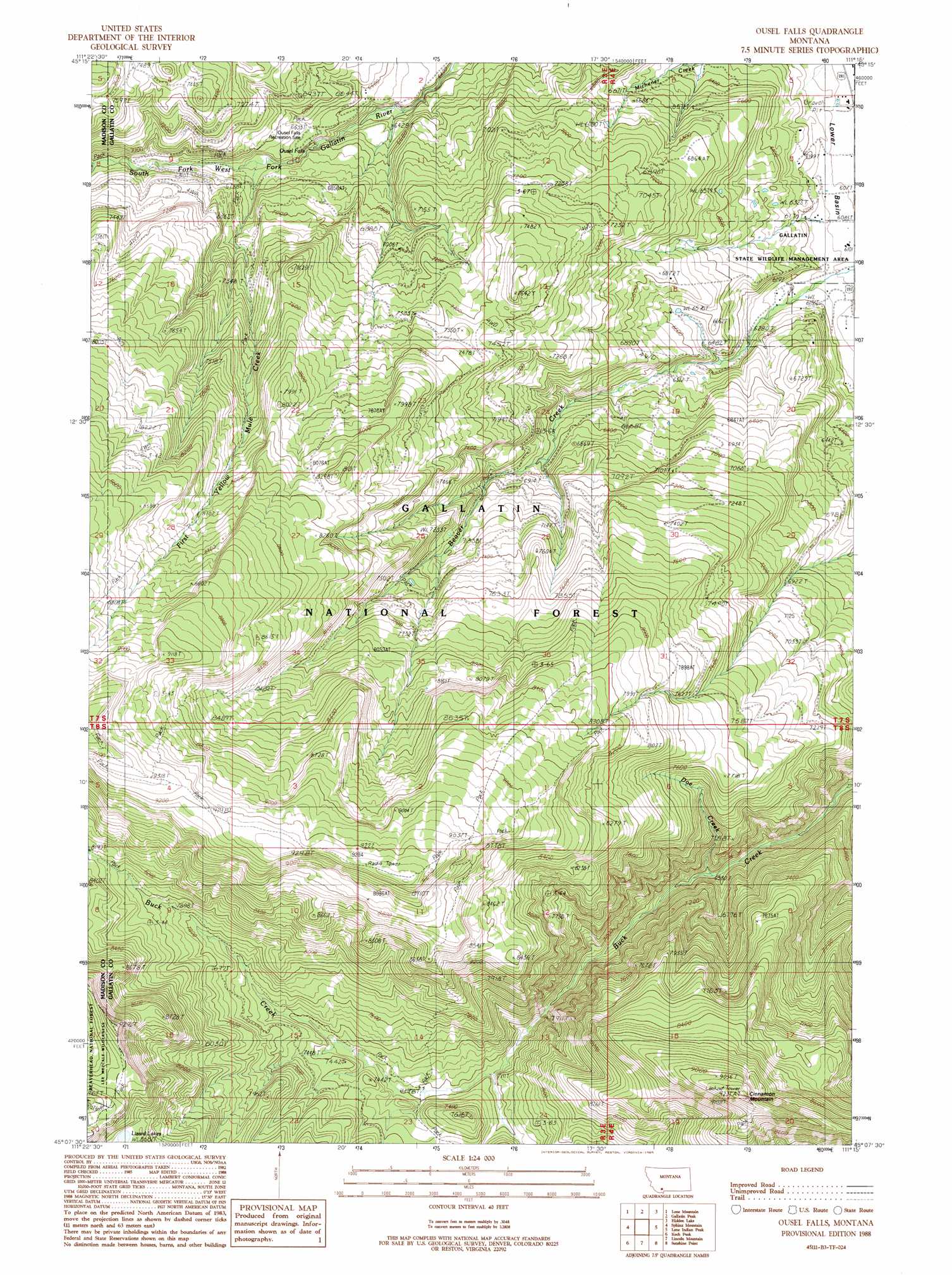
USGS Topo Quad 45111b3 - 1:24,000 scale
| Topo Map Name: | Ousel Falls |
| USGS Topo Quad ID: | 45111b3 |
| Print Size: | ca. 21 1/4" wide x 27" high |
| Southeast Coordinates: | 45.125° N latitude / 111.25° W longitude |
| Map Center Coordinates: | 45.1875° N latitude / 111.3125° W longitude |
| U.S. State: | MT |
| Filename: | o45111b3.jpg |
| Download Map JPG Image: | Ousel Falls topo map 1:24,000 scale |
| Map Type: | Topographic |
| Topo Series: | 7.5´ |
| Map Scale: | 1:24,000 |
| Source of Map Images: | United States Geological Survey (USGS) |
| Alternate Map Versions: |
Ousel Falls MT 1988, updated 1989 Download PDF Buy paper map Ousel Falls MT 1988, updated 1989 Download PDF Buy paper map Ousel Falls MT 2000, updated 2005 Download PDF Buy paper map Ousel Falls MT 2011 Download PDF Buy paper map Ousel Falls MT 2014 Download PDF Buy paper map |
| FStopo: | US Forest Service topo Ousel Falls is available: Download FStopo PDF Download FStopo TIF |
1:24,000 Topo Quads surrounding Ousel Falls
Cherry Lake |
Willow Swamp |
Beacon Point |
Garnet Mountain |
Mount Blackmore |
Fan Mountain |
Lone Mountain |
Gallatin Peak |
Hidden Lake |
The Sentinel |
Lake Cameron |
Sphinx Mountain |
Ousel Falls |
Lone Indian Peak |
Ramshorn Peak |
No Man Peak |
Koch Peak |
Lincoln Mountain |
Sunshine Point |
Big Horn Peak |
Squaw Creek |
Hilgard Peak |
Pika Point |
Upper Tepee Basin |
Divide Lake |
> Back to 45111a1 at 1:100,000 scale
> Back to 45110a1 at 1:250,000 scale
> Back to U.S. Topo Maps home
Ousel Falls topo map: Gazetteer
Ousel Falls: Falls
Ousel Falls elevation 2016m 6614′Ousel Falls: Lakes
Lizard Lakes elevation 2657m 8717′Ousel Falls: Streams
Doe Creek elevation 2002m 6568′First Yellow Mule Creek elevation 2022m 6633′
Ousel Falls: Summits
Cinnamon Mountain elevation 2812m 9225′Ousel Falls digital topo map on disk
Buy this Ousel Falls topo map showing relief, roads, GPS coordinates and other geographical features, as a high-resolution digital map file on DVD: