Sphinx Mountain Topo Map Montana
To zoom in, hover over the map of Sphinx Mountain
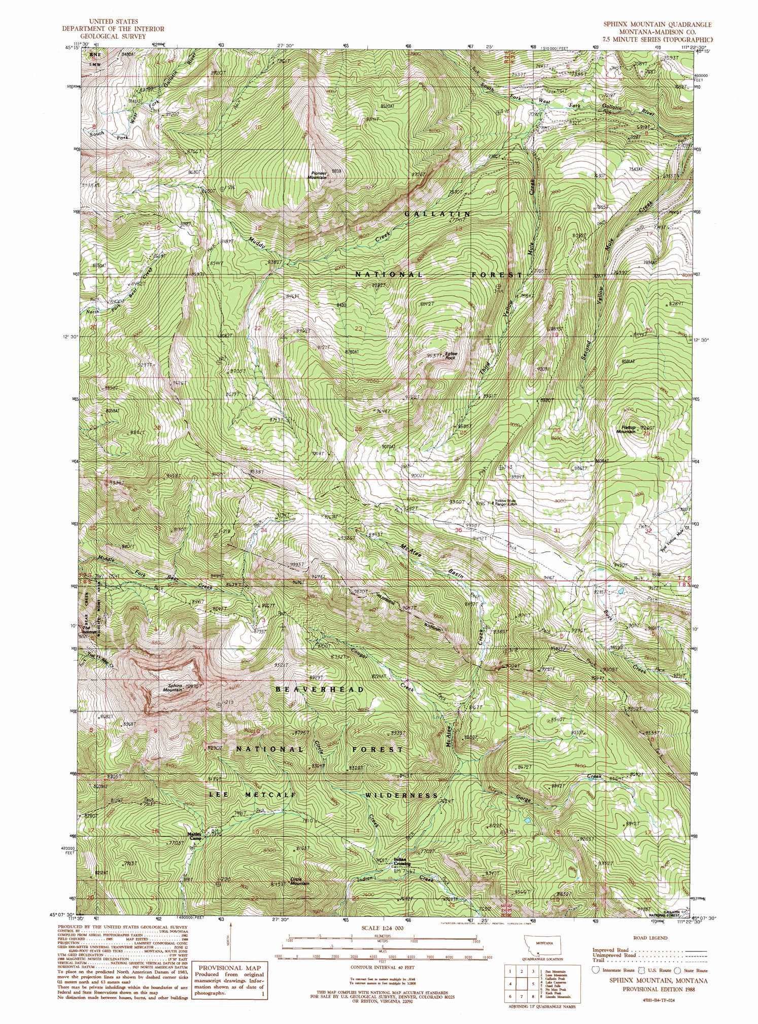
USGS Topo Quad 45111b4 - 1:24,000 scale
| Topo Map Name: | Sphinx Mountain |
| USGS Topo Quad ID: | 45111b4 |
| Print Size: | ca. 21 1/4" wide x 27" high |
| Southeast Coordinates: | 45.125° N latitude / 111.375° W longitude |
| Map Center Coordinates: | 45.1875° N latitude / 111.4375° W longitude |
| U.S. State: | MT |
| Filename: | o45111b4.jpg |
| Download Map JPG Image: | Sphinx Mountain topo map 1:24,000 scale |
| Map Type: | Topographic |
| Topo Series: | 7.5´ |
| Map Scale: | 1:24,000 |
| Source of Map Images: | United States Geological Survey (USGS) |
| Alternate Map Versions: |
Sphinx Mountain MT 1988, updated 1989 Download PDF Buy paper map Sphinx Mountain MT 1988, updated 1989 Download PDF Buy paper map Sphinx Mountain MT 1997, updated 2002 Download PDF Buy paper map Sphinx Mountain MT 2005, updated 2005 Download PDF Buy paper map Sphinx Mountain MT 2011 Download PDF Buy paper map Sphinx Mountain MT 2014 Download PDF Buy paper map |
| FStopo: | US Forest Service topo Sphinx Mountain is available: Download FStopo PDF Download FStopo TIF |
1:24,000 Topo Quads surrounding Sphinx Mountain
Ennis Lake |
Cherry Lake |
Willow Swamp |
Beacon Point |
Garnet Mountain |
Ennis |
Fan Mountain |
Lone Mountain |
Gallatin Peak |
Hidden Lake |
Cameron |
Lake Cameron |
Sphinx Mountain |
Ousel Falls |
Lone Indian Peak |
Bucks Nest |
No Man Peak |
Koch Peak |
Lincoln Mountain |
Sunshine Point |
Granite Mountain |
Squaw Creek |
Hilgard Peak |
Pika Point |
Upper Tepee Basin |
> Back to 45111a1 at 1:100,000 scale
> Back to 45110a1 at 1:250,000 scale
> Back to U.S. Topo Maps home
Sphinx Mountain topo map: Gazetteer
Sphinx Mountain: Basins
McAtee Basin elevation 2656m 8713′Sphinx Mountain: Crossings
Indian Crossing elevation 2268m 7440′Sphinx Mountain: Pillars
Eglise Rock elevation 2891m 9484′Sphinx Mountain: Streams
Circle Creek elevation 2254m 7395′Cougar Creek elevation 2375m 7791′
Gorge Creek elevation 2344m 7690′
McAtee Creek elevation 2257m 7404′
Muddy Creek elevation 2161m 7089′
Second Yellow Mule Creek elevation 2081m 6827′
Third Yellow Mule Creek elevation 2185m 7168′
Sphinx Mountain: Summits
Circle Mountain elevation 2575m 8448′Flattop Mountain elevation 2821m 9255′
Pioneer Mountain elevation 2985m 9793′
Sphinx Mountain elevation 3304m 10839′
Sphinx Mountain digital topo map on disk
Buy this Sphinx Mountain topo map showing relief, roads, GPS coordinates and other geographical features, as a high-resolution digital map file on DVD: