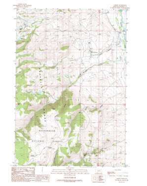
Varney Topo Map Montana
To zoom in, hover over the map of Varney
USGS Topo Quad 45111b7 - 1:24,000 scale
| Topo Map Name: | Varney |
| USGS Topo Quad ID: | 45111b7 |
| Print Size: | ca. 21 1/4" wide x 27" high |
| Southeast Coordinates: | 45.125° N latitude / 111.75° W longitude |
| Map Center Coordinates: | 45.1875° N latitude / 111.8125° W longitude |
| U.S. State: | MT |
| Filename: | o45111b7.jpg |
| Download Map JPG Image: | Varney topo map 1:24,000 scale |
| Map Type: | Topographic |
| Topo Series: | 7.5´ |
| Map Scale: | 1:24,000 |
| Source of Map Images: | United States Geological Survey (USGS) |
| Alternate Map Versions: |
Varney MT 1988, updated 1989 Download PDF Buy paper map Varney MT 1997, updated 2002 Download PDF Buy paper map Varney MT 2011 Download PDF Buy paper map Varney MT 2014 Download PDF Buy paper map |
| FStopo: | US Forest Service topo Varney is available: Download FStopo PDF Download FStopo TIF |
1:24,000 Topo Quads surrounding Varney
> Back to 45111a1 at 1:100,000 scale
> Back to 45110a1 at 1:250,000 scale
> Back to U.S. Topo Maps home
Varney topo map: Gazetteer
Varney: Bridges
Varney Bridge elevation 1569m 5147′Varney: Dams
East Axolotl Lake Dam elevation 2146m 7040′Varney: Lakes
Axolotl Lake elevation 2226m 7303′Axolotl Lakes elevation 2190m 7185′
Haypress Lakes elevation 2125m 6971′
Heart Lake elevation 2192m 7191′
Reservoir Lake elevation 2192m 7191′
Twin Lakes elevation 2106m 6909′
Varney: Populated Places
Varney elevation 1586m 5203′Woodward Place elevation 1819m 5967′
Varney: Post Offices
Varney Post Office (historical) elevation 1586m 5203′Varney: Reservoirs
Call Road Reservoir elevation 2387m 7831′Doubtful Reservoir elevation 2315m 7595′
Varney: Springs
07S02W13CAC_01 Spring elevation 1705m 5593′Blaine Spring elevation 1707m 5600′
Varney: Streams
Haypress Creek elevation 1865m 6118′Wigwam Creek elevation 1579m 5180′
Varney: Valleys
Canyon Gulch elevation 1833m 6013′Dry Hollow elevation 1714m 5623′
Varney: Wells
07S01W07DBCD01 Well elevation 1617m 5305′07S01W17BBBB01 Well elevation 1582m 5190′
07S01W17BCBD01 Well elevation 1587m 5206′
07S01W18DDAC01 Well elevation 1605m 5265′
07S01W20CBAA01 Well elevation 1599m 5246′
07S02W24CCBD01 Well elevation 1711m 5613′
Varney digital topo map on disk
Buy this Varney topo map showing relief, roads, GPS coordinates and other geographical features, as a high-resolution digital map file on DVD:


