Manhattan Sw Topo Map Montana
To zoom in, hover over the map of Manhattan Sw
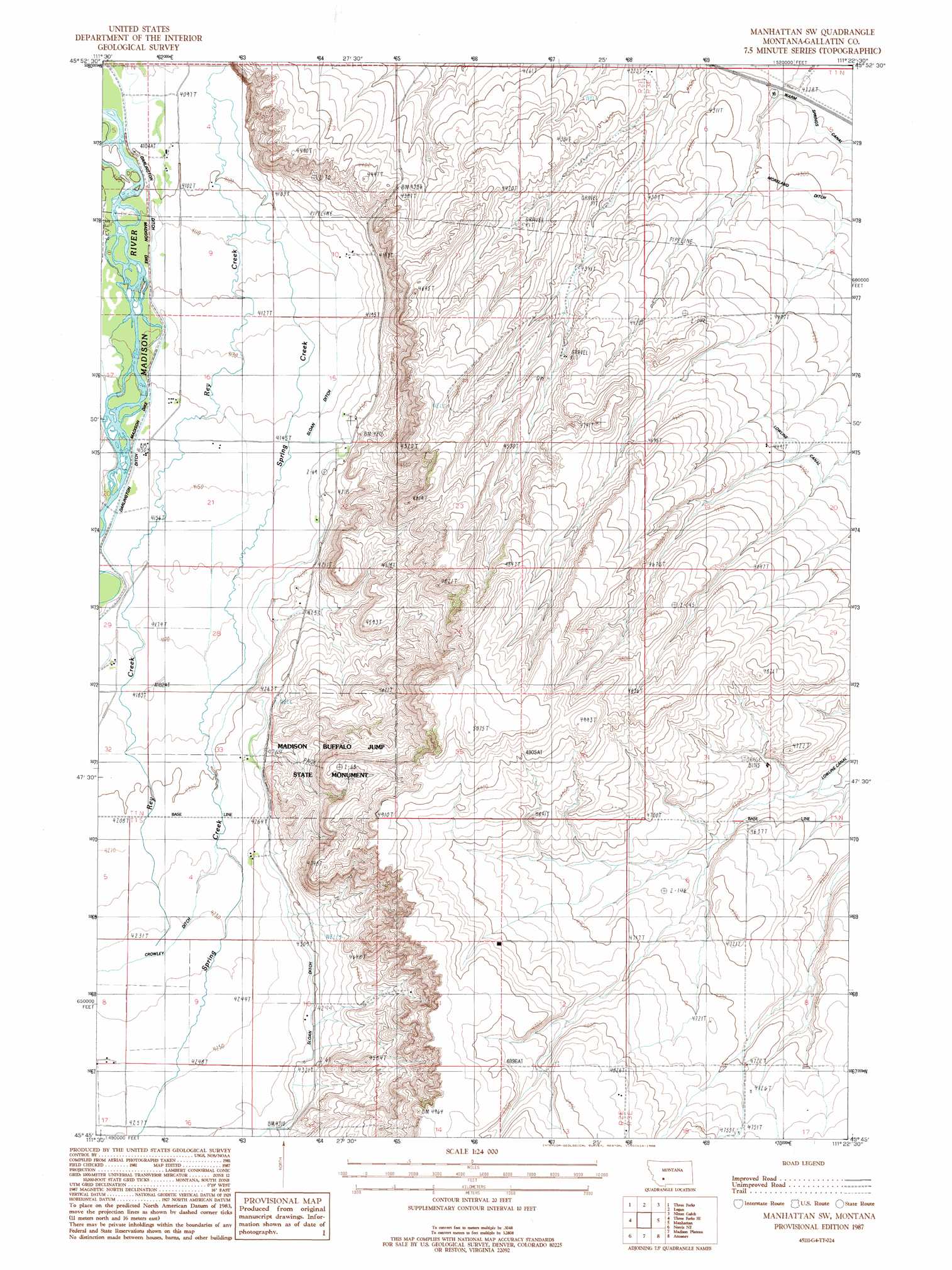
USGS Topo Quad 45111g4 - 1:24,000 scale
| Topo Map Name: | Manhattan Sw |
| USGS Topo Quad ID: | 45111g4 |
| Print Size: | ca. 21 1/4" wide x 27" high |
| Southeast Coordinates: | 45.75° N latitude / 111.375° W longitude |
| Map Center Coordinates: | 45.8125° N latitude / 111.4375° W longitude |
| U.S. State: | MT |
| Filename: | o45111g4.jpg |
| Download Map JPG Image: | Manhattan Sw topo map 1:24,000 scale |
| Map Type: | Topographic |
| Topo Series: | 7.5´ |
| Map Scale: | 1:24,000 |
| Source of Map Images: | United States Geological Survey (USGS) |
| Alternate Map Versions: |
Manhattan SW MT 1987, updated 1988 Download PDF Buy paper map Manhattan SW MT 2011 Download PDF Buy paper map Manhattan SW MT 2014 Download PDF Buy paper map |
1:24,000 Topo Quads surrounding Manhattan Sw
Radersburg Sw |
Plunket Lake |
Lombard |
Roy Gulch |
Maudlow |
Milligan Canyon |
Three Forks |
Logan |
Nixon Gulch |
Horseshoe Creek |
Willow Creek |
Three Forks Se |
Manhattan Sw |
Manhattan |
Belgrade |
Willow Creek Reservoir |
Norris Ne |
Madison Plateau |
Anceney |
Bozeman Hot Springs |
Norris |
Bear Trap Creek |
Cherry Creek Canyon |
Ruby Mountain |
Gallatin Gateway |
> Back to 45111e1 at 1:100,000 scale
> Back to 45110a1 at 1:250,000 scale
> Back to U.S. Topo Maps home
Manhattan Sw topo map: Gazetteer
Manhattan Sw: Canals
Crowley Ditch elevation 1291m 4235′Darlington Ditch elevation 1251m 4104′
Manhattan Sw: Levees
Madison Dike elevation 1255m 4117′Manhattan Sw: Parks
Madison Buffalo Jump State Monument elevation 1388m 4553′Manhattan Sw: Populated Places
Lower Madison (historical) elevation 1260m 4133′Manhattan Sw: Streams
Spring Creek elevation 1286m 4219′Manhattan Sw: Wells
01N02E04CB__01 Well elevation 1250m 4101′01N02E04DCCC01 Well elevation 1251m 4104′
01N02E09BBB_01 Well elevation 1251m 4104′
01N02E10DB__01 Well elevation 1259m 4130′
01N02E10DBAB01 Well elevation 1261m 4137′
01N02E12AA__01 Well elevation 1321m 4333′
01N02E15DCBB01 Well elevation 1270m 4166′
01N02E15DCBD01 Well elevation 1272m 4173′
01N02E15DD__01 Well elevation 1361m 4465′
01N02E16CBD_01 Well elevation 1263m 4143′
01N02E20ADDB01 Well elevation 1266m 4153′
01N02E21ABBA01 Well elevation 1264m 4146′
01N02E21ABBB01 Well elevation 1264m 4146′
01N02E22AB__01 Well elevation 1289m 4229′
01N02E22ABB_01 Well elevation 1270m 4166′
01N02E22ABBB01 Well elevation 1270m 4166′
01N02E22BABA01 Well elevation 1264m 4146′
01N02E22BADD01 Well elevation 1281m 4202′
01N02E22CA__01 Well elevation 1272m 4173′
01N02E22CABD01 Well elevation 1268m 4160′
01N02E22CDCC01 Well elevation 1279m 4196′
01N02E26AB__01 Well elevation 1466m 4809′
01N02E27BBDA01 Well elevation 1287m 4222′
01N02E27BCCB01 Well elevation 1285m 4215′
01N02E29ADC_01 Well elevation 1271m 4169′
01N02E29DCA_01 Well elevation 1272m 4173′
01N02E33DAB_01 Well elevation 1290m 4232′
01N02E34CB__01 Well elevation 1322m 4337′
01N03E07CDDA01 Well elevation 1350m 4429′
01N03E19ADBB01 Well elevation 1380m 4527′
01N03E19DADC01 Well elevation 1399m 4589′
01N03E20CADA01 Well elevation 1383m 4537′
01S02E01ADBD01 Well elevation 1421m 4662′
01S02E01BDDD01 Well elevation 1433m 4701′
01S02E02DD__01 Well elevation 1471m 4826′
01S02E03DCC_01 Well elevation 1329m 4360′
01S02E03DCCC02 Well elevation 1320m 4330′
01S02E04AACC01 Well elevation 1288m 4225′
01S02E10ABBB01 Well elevation 1317m 4320′
01S02E10AC__01 Well elevation 1321m 4333′
01S02E10CAAC01 Well elevation 1313m 4307′
01S02E12BA__01 Well elevation 1460m 4790′
01S02E13AA__01 Well elevation 1483m 4865′
01S02E17AAAB01 Well elevation 1296m 4251′
Manhattan Sw digital topo map on disk
Buy this Manhattan Sw topo map showing relief, roads, GPS coordinates and other geographical features, as a high-resolution digital map file on DVD: