Sappington Topo Map Montana
To zoom in, hover over the map of Sappington
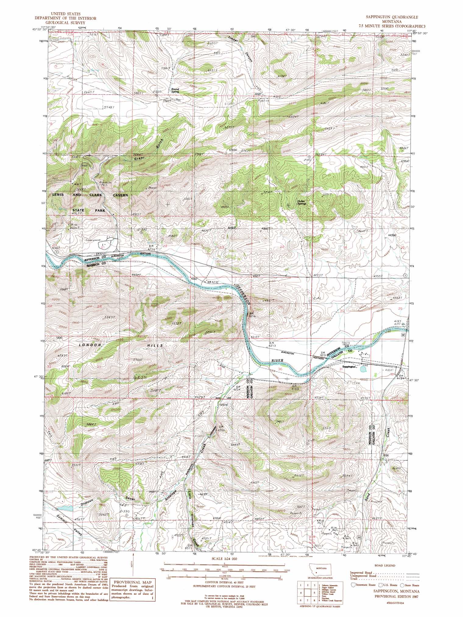
USGS Topo Quad 45111g7 - 1:24,000 scale
| Topo Map Name: | Sappington |
| USGS Topo Quad ID: | 45111g7 |
| Print Size: | ca. 21 1/4" wide x 27" high |
| Southeast Coordinates: | 45.75° N latitude / 111.75° W longitude |
| Map Center Coordinates: | 45.8125° N latitude / 111.8125° W longitude |
| U.S. State: | MT |
| Filename: | o45111g7.jpg |
| Download Map JPG Image: | Sappington topo map 1:24,000 scale |
| Map Type: | Topographic |
| Topo Series: | 7.5´ |
| Map Scale: | 1:24,000 |
| Source of Map Images: | United States Geological Survey (USGS) |
| Alternate Map Versions: |
Sappington MT 1987, updated 1988 Download PDF Buy paper map Sappington MT 2011 Download PDF Buy paper map Sappington MT 2014 Download PDF Buy paper map |
1:24,000 Topo Quads surrounding Sappington
Wilson Park |
Dunn Creek |
Willow Springs |
Radersburg Sw |
Plunket Lake |
Black Butte |
Doherty Mountain |
Negro Hollow |
Milligan Canyon |
Three Forks |
Whitehall |
Jefferson Island |
Sappington |
Willow Creek |
Three Forks Se |
Manhead Mountain |
Pony |
Harrison |
Willow Creek Reservoir |
Norris Ne |
Noble Peak |
Potosi Peak |
Maltbys Mound |
Norris |
Bear Trap Creek |
> Back to 45111e1 at 1:100,000 scale
> Back to 45110a1 at 1:250,000 scale
> Back to U.S. Topo Maps home
Sappington topo map: Gazetteer
Sappington: Dams
George Hemund Dam elevation 1401m 4596′Hemund Dam elevation 1442m 4730′
Sappington: Mines
Harrison Highway Mine elevation 1383m 4537′NE NE Section 20 Mine elevation 1391m 4563′
NE SE Section 8 Mine elevation 1379m 4524′
NW SE Section 7 Mine elevation 1459m 4786′
Sappington Mica Mine elevation 1433m 4701′
SE SW Section 24 Mine elevation 1403m 4603′
Sappington: Populated Places
Sappington elevation 1274m 4179′Sappington: Post Offices
Cavern Post Office (historical) elevation 1657m 5436′Sandcreek Post Office (historical) elevation 1440m 4724′
Sappington Post Office (historical) elevation 1274m 4179′
Sappington: Springs
Huller Springs elevation 1477m 4845′Round Spring elevation 1736m 5695′
Sappington: Streams
Antelope Creek elevation 1276m 4186′Dogtown Sewer elevation 1363m 4471′
Little Antelope Creek elevation 1353m 4438′
Sappington: Summits
Dolomite Knob elevation 1696m 5564′London Hills elevation 1839m 6033′
Sappington: Valleys
Greer Gulch elevation 1511m 4957′Sappington: Wells
01N01W31BDDA01 Well elevation 1274m 4179′Sappington digital topo map on disk
Buy this Sappington topo map showing relief, roads, GPS coordinates and other geographical features, as a high-resolution digital map file on DVD: