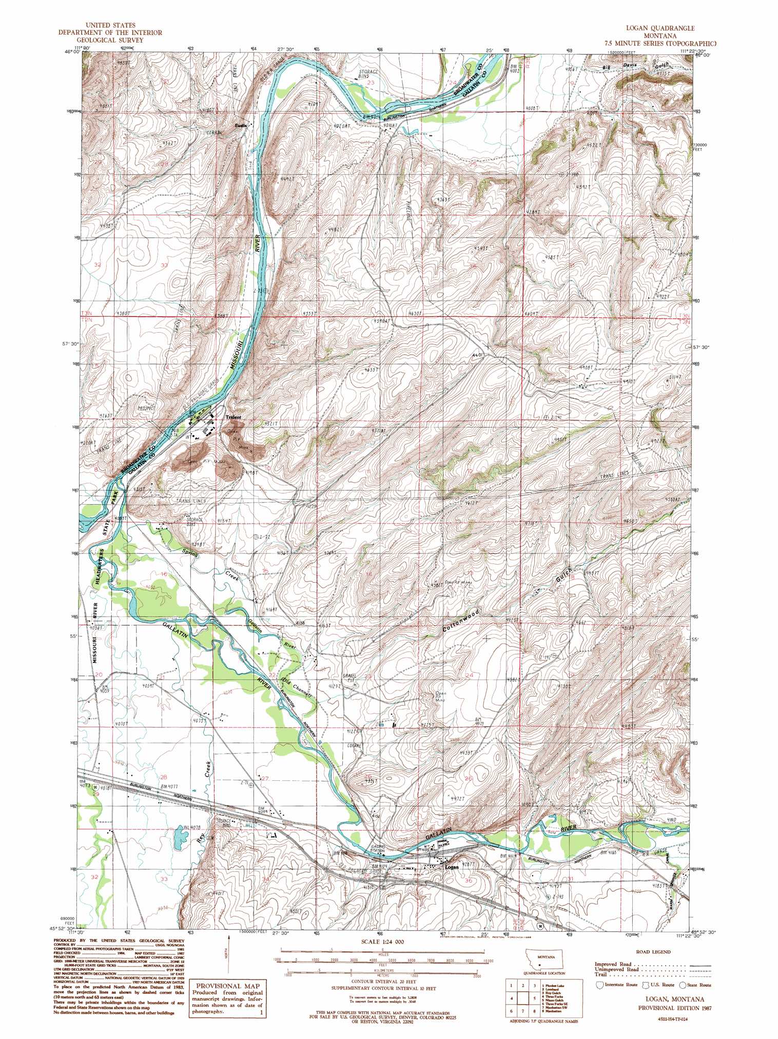
Logan Topo Map Montana
To zoom in, hover over the map of Logan
USGS Topo Quad 45111h4 - 1:24,000 scale
| Topo Map Name: | Logan |
| USGS Topo Quad ID: | 45111h4 |
| Print Size: | ca. 21 1/4" wide x 27" high |
| Southeast Coordinates: | 45.875° N latitude / 111.375° W longitude |
| Map Center Coordinates: | 45.9375° N latitude / 111.4375° W longitude |
| U.S. State: | MT |
| Filename: | o45111h4.jpg |
| Download Map JPG Image: | Logan topo map 1:24,000 scale |
| Map Type: | Topographic |
| Topo Series: | 7.5´ |
| Map Scale: | 1:24,000 |
| Source of Map Images: | United States Geological Survey (USGS) |
| Alternate Map Versions: |
Logan MT 1987, updated 1988 Download PDF Buy paper map Logan MT 1987, updated 1988 Download PDF Buy paper map Logan MT 2011 Download PDF Buy paper map Logan MT 2014 Download PDF Buy paper map |
1:24,000 Topo Quads surrounding Logan
Radersburg |
Parker |
Toston |
Deer Park |
Sixmile Mountain |
Radersburg Sw |
Plunket Lake |
Lombard |
Roy Gulch |
Maudlow |
Milligan Canyon |
Three Forks |
Logan |
Nixon Gulch |
Horseshoe Creek |
Willow Creek |
Three Forks Se |
Manhattan Sw |
Manhattan |
Belgrade |
Willow Creek Reservoir |
Norris Ne |
Madison Plateau |
Anceney |
Bozeman Hot Springs |
> Back to 45111e1 at 1:100,000 scale
> Back to 45110a1 at 1:250,000 scale
> Back to U.S. Topo Maps home
Logan topo map: Gazetteer
Logan: Bridges
Logan Bridge elevation 1247m 4091′Northern Pacific Railroad Bridge elevation 1249m 4097′
Trident Bridge elevation 1232m 4041′
Logan: Canals
Warm Springs Canal elevation 1261m 4137′Logan: Crossings
Interchange 283 elevation 1259m 4130′Logan: Parks
Missouri River Headwaters State Park elevation 1234m 4048′Logan: Populated Places
Carpenter elevation 1246m 4087′Eustis elevation 1231m 4038′
Gallatin (historical) elevation 1232m 4041′
Logan elevation 1255m 4117′
Trident elevation 1230m 4035′
Logan: Post Offices
Gallatin Post Office (historical) elevation 1232m 4041′Logan Post Office (historical) elevation 1255m 4117′
Trident Post Office (historical) elevation 1230m 4035′
Logan: Springs
02N03E31CD__01 Spring elevation 1282m 4206′02N03E32AC__01 Spring elevation 1263m 4143′
Cress Springs elevation 1296m 4251′
Logan: Streams
Gallatin River elevation 1231m 4038′Gallatin River elevation 1231m 4038′
Gallatin River elevation 1231m 4038′
Rey Creek elevation 1239m 4064′
Spring Creek elevation 1231m 4038′
Logan: Valleys
Big Davis Gulch elevation 1245m 4084′Cottonwood Gulch elevation 1256m 4120′
Logan: Wells
02N02E09CBDA01 Well elevation 1232m 4041′02N02E15BCDB01 Well elevation 1246m 4087′
02N02E17DDCC01 Well elevation 1235m 4051′
02N02E20DAC_01 Well elevation 1238m 4061′
02N02E20DDCB01 Well elevation 1239m 4064′
02N02E21ACDB01 Well elevation 1237m 4058′
02N02E22CCC_01 Well elevation 1242m 4074′
02N02E27CADD01 Well elevation 1244m 4081′
02N02E27CBC_01 Well elevation 1244m 4081′
02N02E27CDDC01 Well elevation 1254m 4114′
02N02E27DCA_01 Well elevation 1247m 4091′
02N02E27DCA_02 Well elevation 1247m 4091′
02N02E27DCB_01 Well elevation 1245m 4084′
02N02E28BC__01 Well elevation 1241m 4071′
02N02E28BCD_01 Well elevation 1242m 4074′
02N02E28CADC01 Well elevation 1243m 4078′
02N02E28CADC02 Well elevation 1243m 4078′
02N02E28CADC03 Well elevation 1243m 4078′
02N02E28CADC04 Well elevation 1243m 4078′
02N02E28CBDD01 Well elevation 1243m 4078′
02N02E29AD__01 Well elevation 1242m 4074′
02N02E29DD__01 Well elevation 1244m 4081′
02N02E32AAAA01 Well elevation 1244m 4081′
02N02E32AAAA02 Well elevation 1244m 4081′
02N02E35AB__01 Well elevation 1255m 4117′
02N02E35AB__02 Well elevation 1255m 4117′
02N02E35AD__01 Well elevation 1259m 4130′
02N02E35AD__02 Well elevation 1259m 4130′
02N02E35ADDA01 Well elevation 1264m 4146′
02N02E35BBB_01 Well elevation 1257m 4124′
02N02E35DB__01 Well elevation 1263m 4143′
02N02E35DCD_01 Well elevation 1291m 4235′
02N02E36BA__01 Well elevation 1250m 4101′
02N02E36BB__01 Well elevation 1250m 4101′
02N02E36BC__01 Well elevation 1256m 4120′
02N02E36BCAA01 Well elevation 1251m 4104′
Logan digital topo map on disk
Buy this Logan topo map showing relief, roads, GPS coordinates and other geographical features, as a high-resolution digital map file on DVD: