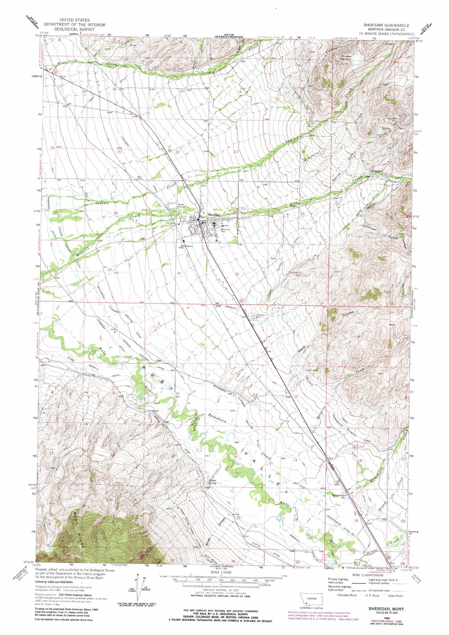
Sheridan Topo Map Montana
To zoom in, hover over the map of Sheridan
USGS Topo Quad 45112d2 - 1:24,000 scale
| Topo Map Name: | Sheridan |
| USGS Topo Quad ID: | 45112d2 |
| Print Size: | ca. 21 1/4" wide x 27" high |
| Southeast Coordinates: | 45.375° N latitude / 112.125° W longitude |
| Map Center Coordinates: | 45.4375° N latitude / 112.1875° W longitude |
| U.S. State: | MT |
| Filename: | o45112d2.jpg |
| Download Map JPG Image: | Sheridan topo map 1:24,000 scale |
| Map Type: | Topographic |
| Topo Series: | 7.5´ |
| Map Scale: | 1:24,000 |
| Source of Map Images: | United States Geological Survey (USGS) |
| Alternate Map Versions: |
Sheridan MT 1963, updated 1964 Download PDF Buy paper map Sheridan MT 1963, updated 1989 Download PDF Buy paper map Sheridan MT 1997, updated 2002 Download PDF Buy paper map Sheridan MT 2011 Download PDF Buy paper map Sheridan MT 2014 Download PDF Buy paper map |
| FStopo: | US Forest Service topo Sheridan is available: Download FStopo PDF Download FStopo TIF |
1:24,000 Topo Quads surrounding Sheridan
Table Mountain |
Silver Star |
Waterloo |
Manhead Mountain |
Pony |
Twin Bridges Sw |
Twin Bridges |
Old Baldy Mountain |
Noble Peak |
Potosi Peak |
Beaverhead Rock |
Beaverhead Rock Ne |
Sheridan |
Copper Mountain |
Ramshorn Mountain |
Beaverhead Rock Sw |
Beaverhead Rock Se |
Laurin Canyon |
Alder |
Virginia City |
Christensen Ranch |
Mine Gulch |
Metzel Ranch |
Ruby Dam |
Cirque Lake |
> Back to 45112a1 at 1:100,000 scale
> Back to 45112a1 at 1:250,000 scale
> Back to U.S. Topo Maps home
Sheridan topo map: Gazetteer
Sheridan: Airports
Tezaks-Colterville Spur Airport elevation 1509m 4950′Sheridan: Canals
Braach Ditch elevation 1743m 5718′Bullerdick Hyndman Moulton Ditch elevation 1501m 4924′
Carey Ditch elevation 1529m 5016′
Clark Sennett Ditch elevation 1488m 4881′
Duncan Edelman Ditch elevation 1490m 4888′
Duncan Edelman Ditch elevation 1482m 4862′
Durham Ditch elevation 1985m 6512′
Elser Tilton Ditch elevation 1611m 5285′
Hermsmyer Raymond Ditch elevation 1569m 5147′
Lueck Marsh Ditch elevation 1693m 5554′
Marshall Ditch Number Three elevation 1519m 4983′
Ruby Valley Ditch elevation 1541m 5055′
Schoolhouse Ditch Number One elevation 1521m 4990′
Schulz Ditch elevation 1708m 5603′
Spring Ditch elevation 1501m 4924′
Thompson Ditch elevation 1477m 4845′
Vigilante Canal elevation 1572m 5157′
West Bench Canal Lateral elevation 1593m 5226′
Sheridan: Dams
Durham Dam elevation 1966m 6450′Sheridan: Mines
Big Chief Mine elevation 1745m 5725′Braach Mine elevation 1895m 6217′
Brandon Mine elevation 1751m 5744′
Broad Gauge Mine elevation 1927m 6322′
Buckeye Mine elevation 1819m 5967′
Elser-Schultz Mine elevation 1717m 5633′
Flamm Ranch Number 1 Mine elevation 1913m 6276′
Flamm Ranch Number 2 Mine elevation 1883m 6177′
Fort Knox Mine elevation 1799m 5902′
Horse Creek Bull Quartz Mine elevation 1779m 5836′
Leuck Mine elevation 1691m 5547′
NE SE Section 19 Mine elevation 1755m 5757′
NE SE Section 30 Mine elevation 1741m 5711′
NW NW Section 29 Mine elevation 1789m 5869′
NW SE Section 30 Mine elevation 1689m 5541′
Rattlesnake Gulch Mine elevation 1767m 5797′
Rodewald Ranch Number 1 Mine elevation 1754m 5754′
Rodewald Ranch Number 2 Mine elevation 1772m 5813′
Roylance Mine elevation 1799m 5902′
SE SE Section 18 Mine elevation 1900m 6233′
SE SW Section 30 Mine elevation 1718m 5636′
Spring Park Creek Mine elevation 1802m 5912′
SW NE SE Section 30 Mine elevation 1757m 5764′
SW NW Section 20 Mine elevation 1752m 5748′
SW SW Section 29 Mine elevation 1773m 5816′
Tamarack Mine elevation 1884m 6181′
Tamarack Mine elevation 1882m 6174′
Sheridan: Parks
Robbers Roost Historical Marker elevation 1522m 4993′Sheridan City Park elevation 1546m 5072′
Sheridan: Populated Places
Brandon elevation 1719m 5639′Sheridan elevation 1559m 5114′
Sheridan Trailer Court elevation 1564m 5131′
Sheridan: Post Offices
Sheridan Post Office elevation 1559m 5114′Sheridan: Reservoirs
Durham Reservoir elevation 1965m 6446′Sheridan: Springs
Silver Spring elevation 1506m 4940′Sheridan: Streams
Antelope Creek elevation 1775m 5823′Bivens Creek elevation 1525m 5003′
Branch Creek elevation 1540m 5052′
Clear Creek elevation 1519m 4983′
Horse Creek elevation 1505m 4937′
Nonpariel Creek elevation 1572m 5157′
Nugget Creek elevation 1648m 5406′
Ramshorn Creek elevation 1495m 4904′
Spring Park Creek elevation 1655m 5429′
Sheridan: Valleys
Antelope Gulch elevation 1697m 5567′Bivens Gulch elevation 1539m 5049′
Bouge Canyon elevation 1517m 4977′
Ruby Valley elevation 1473m 4832′
Sand Coulee elevation 1524m 5000′
Sheridan: Wells
04S04W19DDDC01 Well elevation 1734m 5688′04S04W30BCBB01 Well elevation 1671m 5482′
04S05W11DDDD01 Well elevation 1689m 5541′
04S05W12CCBB01 Well elevation 1696m 5564′
04S05W16DDBC01 Well elevation 1551m 5088′
04S05W16DDCD01 Well elevation 1552m 5091′
04S05W27DBAB01 Well elevation 1545m 5068′
04S05W27DBBC01 Well elevation 1541m 5055′
04S05W27DBD_02 Well elevation 1549m 5082′
04S05W32DBCC01 Well elevation 1474m 4835′
05S04W19BABA01 Well elevation 1523m 4996′
05S04W19BABB01 Well elevation 1522m 4993′
05S04W19BABD01 Well elevation 1523m 4996′
05S05W02DDAA01 Well elevation 1554m 5098′
05S05W03CBBA01 Well elevation 1509m 4950′
05S05W03CBBB01 Well elevation 1506m 4940′
05S05W09DBDA01 Well elevation 1508m 4947′
05S05W25BAAA01 Well elevation 1525m 5003′
05S05W25BBBB01 Well elevation 1538m 5045′
Sheridan digital topo map on disk
Buy this Sheridan topo map showing relief, roads, GPS coordinates and other geographical features, as a high-resolution digital map file on DVD: