Cattle Gulch Topo Map Montana
To zoom in, hover over the map of Cattle Gulch
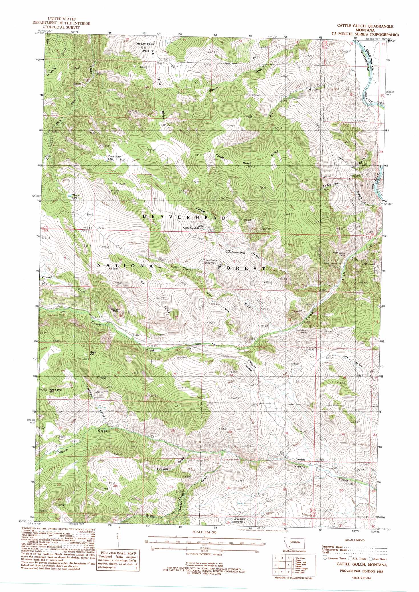
USGS Topo Quad 45112f7 - 1:24,000 scale
| Topo Map Name: | Cattle Gulch |
| USGS Topo Quad ID: | 45112f7 |
| Print Size: | ca. 21 1/4" wide x 27" high |
| Southeast Coordinates: | 45.625° N latitude / 112.75° W longitude |
| Map Center Coordinates: | 45.6875° N latitude / 112.8125° W longitude |
| U.S. State: | MT |
| Filename: | o45112f7.jpg |
| Download Map JPG Image: | Cattle Gulch topo map 1:24,000 scale |
| Map Type: | Topographic |
| Topo Series: | 7.5´ |
| Map Scale: | 1:24,000 |
| Source of Map Images: | United States Geological Survey (USGS) |
| Alternate Map Versions: |
Cattle Gulch MT 1988, updated 1988 Download PDF Buy paper map Cattle Gulch MT 2011 Download PDF Buy paper map Cattle Gulch MT 2014 Download PDF Buy paper map |
| FStopo: | US Forest Service topo Cattle Gulch is available: Download FStopo PDF Download FStopo TIF |
1:24,000 Topo Quads surrounding Cattle Gulch
Lincoln Gulch |
Dickie Peak |
Burnt Mountain |
Buxton |
Butte South |
Dickie Hills |
Wise River |
Dewey |
Tucker Creek |
Mount Humbug |
Stine Mountain |
Vipond Park |
Cattle Gulch |
Melrose |
Wickiup Creek |
Maurice Mountain |
Mount Tahepia |
Storm Peak |
Earls Gulch |
Nez Perce Hollow |
Elkhorn Hot Springs |
Torrey Mountain |
Twin Adams Mountain |
Glen |
Block Mountain |
> Back to 45112e1 at 1:100,000 scale
> Back to 45112a1 at 1:250,000 scale
> Back to U.S. Topo Maps home
Cattle Gulch topo map: Gazetteer
Cattle Gulch: Bends
Devils Hole elevation 2088m 6850′Cattle Gulch: Cliffs
Long Slope elevation 2131m 6991′Short Slope elevation 1948m 6391′
Cattle Gulch: Flats
Picketts Pasture elevation 1906m 6253′Sage Flat elevation 2253m 7391′
Cattle Gulch: Lakes
Cattle Gulch Lake elevation 2494m 8182′Trusty Lake elevation 2358m 7736′
Cattle Gulch: Mines
North Central Mine elevation 1673m 5488′NW NW Section 18 Mine elevation 1926m 6318′
Short Shift Mine elevation 2291m 7516′
West Limb Mine elevation 1833m 6013′
Cattle Gulch: Parks
Happy Camp Park elevation 2167m 7109′Cattle Gulch: Populated Places
Glendale elevation 1716m 5629′Cattle Gulch: Post Offices
Glendale Post Office (historical) elevation 1716m 5629′Cattle Gulch: Ridges
Cattle Gulch Ridge elevation 2440m 8005′Nez Perce Ridge elevation 2263m 7424′
Cattle Gulch: Springs
Lower Cattle Gulch Spring elevation 2021m 6630′Trusty Gulch Spring One elevation 1793m 5882′
Trusty Gulch Spring Two elevation 2038m 6686′
Upper Cattle Gulch Spring elevation 2095m 6873′
Cattle Gulch: Streams
Divide Creek elevation 1634m 5360′Sucker Creek elevation 1781m 5843′
Vipond Creek elevation 1954m 6410′
Cattle Gulch: Summits
Ore Camp Hill elevation 2382m 7814′Cattle Gulch: Valleys
Cattle Gulch elevation 1686m 5531′Dry Gulch elevation 1651m 5416′
LaMarche Gulch elevation 1652m 5419′
Letter Gulch elevation 1643m 5390′
Lockridge Canyon elevation 1955m 6414′
Sucker Gulch elevation 1782m 5846′
Towmile Gulch elevation 1802m 5912′
Trusty Gulch elevation 1752m 5748′
Twomile Gulch elevation 1802m 5912′
Cattle Gulch digital topo map on disk
Buy this Cattle Gulch topo map showing relief, roads, GPS coordinates and other geographical features, as a high-resolution digital map file on DVD: