Gibbonsville Topo Map Idaho
To zoom in, hover over the map of Gibbonsville
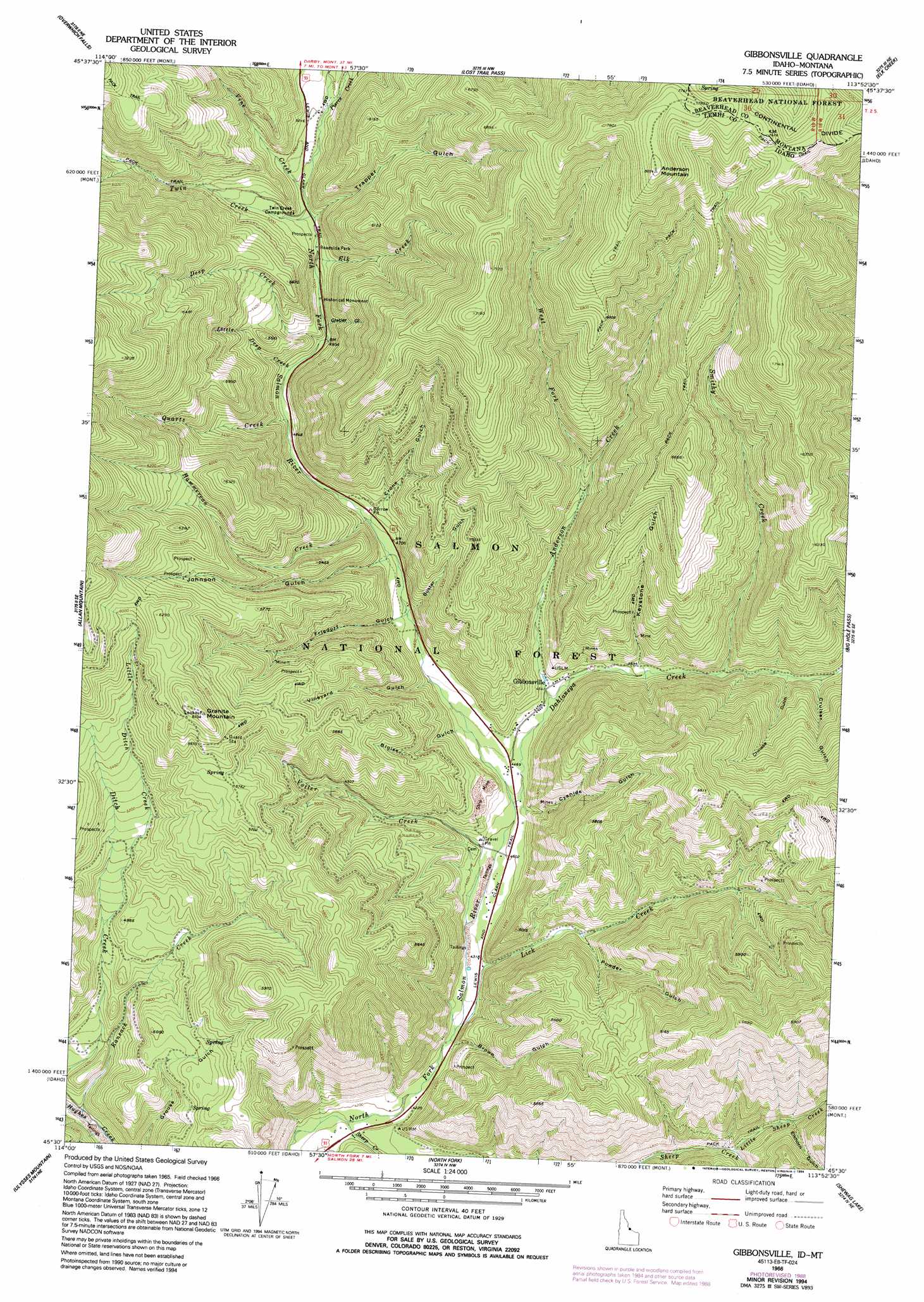
USGS Topo Quad 45113e8 - 1:24,000 scale
| Topo Map Name: | Gibbonsville |
| USGS Topo Quad ID: | 45113e8 |
| Print Size: | ca. 21 1/4" wide x 27" high |
| Southeast Coordinates: | 45.5° N latitude / 113.875° W longitude |
| Map Center Coordinates: | 45.5625° N latitude / 113.9375° W longitude |
| U.S. States: | ID, MT |
| Filename: | o45113e8.jpg |
| Download Map JPG Image: | Gibbonsville topo map 1:24,000 scale |
| Map Type: | Topographic |
| Topo Series: | 7.5´ |
| Map Scale: | 1:24,000 |
| Source of Map Images: | United States Geological Survey (USGS) |
| Alternate Map Versions: |
Gibbonsville ID 1966, updated 1971 Download PDF Buy paper map Gibbonsville ID 1966, updated 1977 Download PDF Buy paper map Gibbonsville ID 1966, updated 1989 Download PDF Buy paper map Gibbonsville ID 1966, updated 1994 Download PDF Buy paper map Gibbonsville ID 1997, updated 2002 Download PDF Buy paper map Gibbonsville ID 2011 Download PDF Buy paper map Gibbonsville ID 2013 Download PDF Buy paper map |
| FStopo: | US Forest Service topo Gibbonsville is available: Download FStopo PDF Download FStopo TIF |
1:24,000 Topo Quads surrounding Gibbonsville
Piquett Creek |
Medicine Hot Springs |
Sula |
Schultz Saddle |
Bender Point |
Piquett Mountain |
Overwhich Falls |
Lost Trail Pass |
Elk Creek |
Big Hole Battlefield |
Henderson Ridge |
Allan Mountain |
Gibbonsville |
Big Hole Pass |
Isaac Meadows |
Ulysses |
Ulysses Mountain |
North Fork |
Shewag Lake |
Jumbo Mountain |
Pine Creek Ridge |
Napoleon Hill |
Bird Creek |
Badger Spring Gulch |
Homer Youngs Peak |
> Back to 45113e1 at 1:100,000 scale
> Back to 45112a1 at 1:250,000 scale
> Back to U.S. Topo Maps home
Gibbonsville topo map: Gazetteer
Gibbonsville: Populated Places
Gibbonsville elevation 1393m 4570′Gibbonsville: Streams
Anderson Creek elevation 1384m 4540′Dahlonega Creek elevation 1351m 4432′
Deep Creek elevation 1528m 5013′
Elk Creek elevation 1558m 5111′
Hammerean Creek elevation 1461m 4793′
Lick Creek elevation 1299m 4261′
Little Deep Creek elevation 1507m 4944′
Little Ditch Creek elevation 1447m 4747′
Little Sheep Creek elevation 1422m 4665′
Pierce Creek elevation 1586m 5203′
Quartz Creek elevation 1499m 4917′
Ransack Creek elevation 1278m 4192′
Smithy Creek elevation 1431m 4694′
Twin Creek elevation 1546m 5072′
Vine Creek elevation 1561m 5121′
Votler Creek elevation 1329m 4360′
West Fork Anderson Creek elevation 1516m 4973′
Gibbonsville: Summits
Anderson Mountain elevation 2438m 7998′Granite Mountain elevation 1923m 6309′
Gibbonsville: Valleys
Bloise Gulch elevation 1415m 4642′Brown Gulch elevation 1298m 4258′
Buster Gulch elevation 1413m 4635′
Chinese Gulch elevation 1465m 4806′
Crone Gulch elevation 1462m 4796′
Cruiser Gulch elevation 1471m 4826′
Cyanide Gulch elevation 1351m 4432′
Elkhorn Gulch elevation 1534m 5032′
Friedorf Gulch elevation 1446m 4744′
Glacier Gulch elevation 1514m 4967′
Johnson Gulch elevation 1438m 4717′
Keystone Gulch elevation 1419m 4655′
Powder Gulch elevation 1404m 4606′
Trapper Gulch elevation 2083m 6833′
Vineyard Gulch elevation 1416m 4645′
Gibbonsville digital topo map on disk
Buy this Gibbonsville topo map showing relief, roads, GPS coordinates and other geographical features, as a high-resolution digital map file on DVD: