Blackbird Mountain Topo Map Idaho
To zoom in, hover over the map of Blackbird Mountain
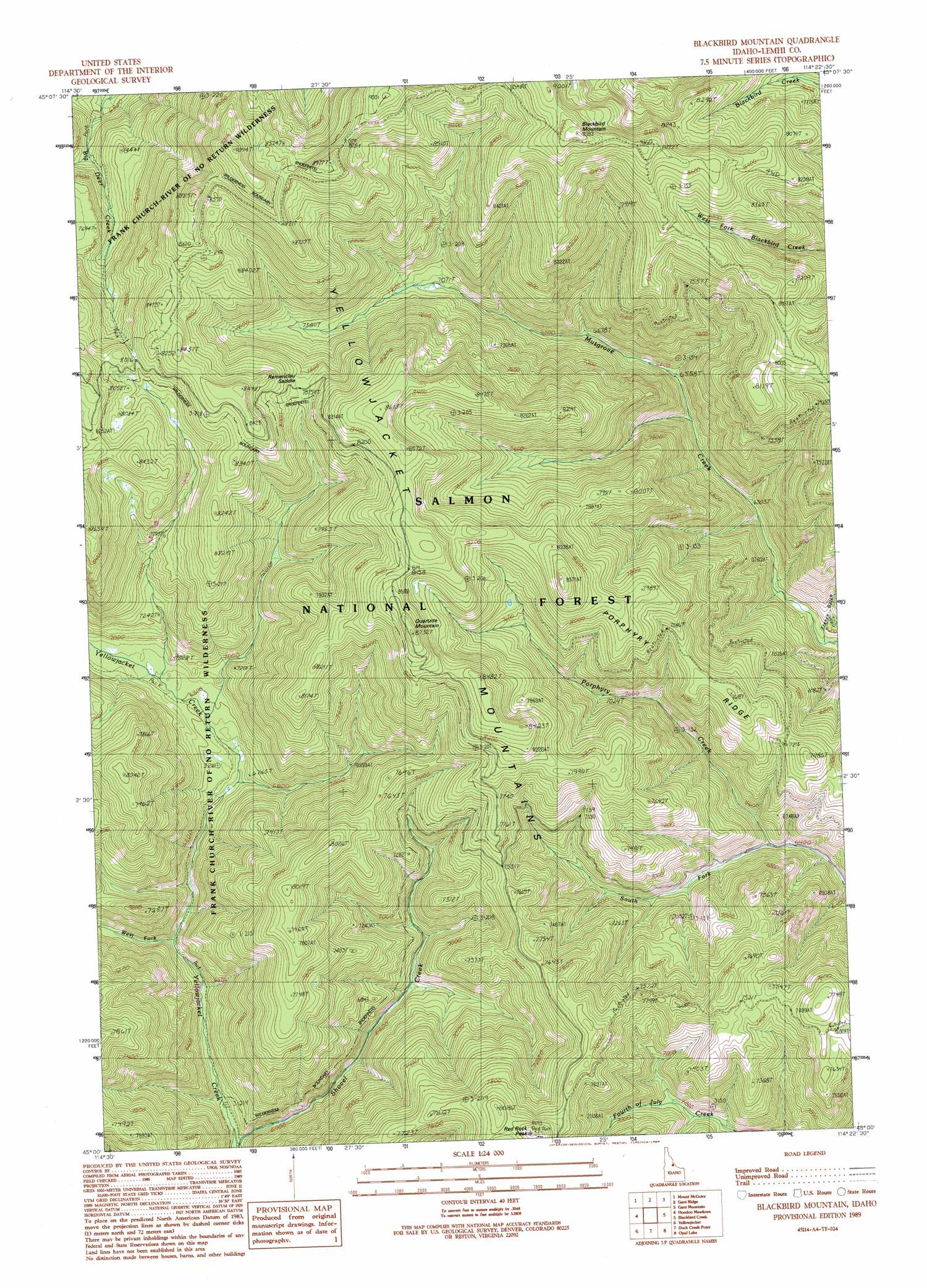
USGS Topo Quad 45114a4 - 1:24,000 scale
| Topo Map Name: | Blackbird Mountain |
| USGS Topo Quad ID: | 45114a4 |
| Print Size: | ca. 21 1/4" wide x 27" high |
| Southeast Coordinates: | 45° N latitude / 114.375° W longitude |
| Map Center Coordinates: | 45.0625° N latitude / 114.4375° W longitude |
| U.S. State: | ID |
| Filename: | o45114a4.jpg |
| Download Map JPG Image: | Blackbird Mountain topo map 1:24,000 scale |
| Map Type: | Topographic |
| Topo Series: | 7.5´ |
| Map Scale: | 1:24,000 |
| Source of Map Images: | United States Geological Survey (USGS) |
| Alternate Map Versions: |
Blackbird Mountain ID 1989, updated 1989 Download PDF Buy paper map Blackbird Mountain ID 2011 Download PDF Buy paper map Blackbird Mountain ID 2013 Download PDF Buy paper map |
| FStopo: | US Forest Service topo Blackbird Mountain is available: Download FStopo PDF Download FStopo TIF |
1:24,000 Topo Quads surrounding Blackbird Mountain
Butts Creek Point |
Long Tom Mountain |
Bighorn Crags |
Pine Creek Rapids |
Pine Creek Ridge |
Aggipah Mountain |
Mount Mcguire |
Gant Ridge |
Gant Mountain |
Jureano Mountain |
Puddin Mountain |
Hoodoo Meadows |
Blackbird Mountain |
Blackbird Creek |
Cobalt |
Aparejo Point |
Yellowjacket |
Duck Creek Point |
Opal Lake |
Taylor Mountain |
Sleeping Deer Mountain |
Meyers Cove |
Meyers Cove Point |
Black Mountain |
Wards Butte |
> Back to 45114a1 at 1:100,000 scale
> Back to 45114a1 at 1:250,000 scale
> Back to U.S. Topo Maps home
Blackbird Mountain topo map: Gazetteer
Blackbird Mountain: Gaps
Remenclau Saddle elevation 2408m 7900′Blackbird Mountain: Ridges
Porphyry Ridge elevation 2158m 7080′Blackbird Mountain: Streams
Meadow Creek elevation 2054m 6738′Shovel Creek elevation 1896m 6220′
South Fork Porphyry Creek elevation 1972m 6469′
West Fork Yellowjacket Creek elevation 1963m 6440′
Blackbird Mountain: Summits
Blackbird Mountain elevation 2757m 9045′Quartzite Mountain elevation 2658m 8720′
Red Rock Peak elevation 2480m 8136′
Blackbird Mountain: Valleys
French Gulch elevation 1897m 6223′Blackbird Mountain digital topo map on disk
Buy this Blackbird Mountain topo map showing relief, roads, GPS coordinates and other geographical features, as a high-resolution digital map file on DVD: