Dave Lewis Peak Topo Map Idaho
To zoom in, hover over the map of Dave Lewis Peak
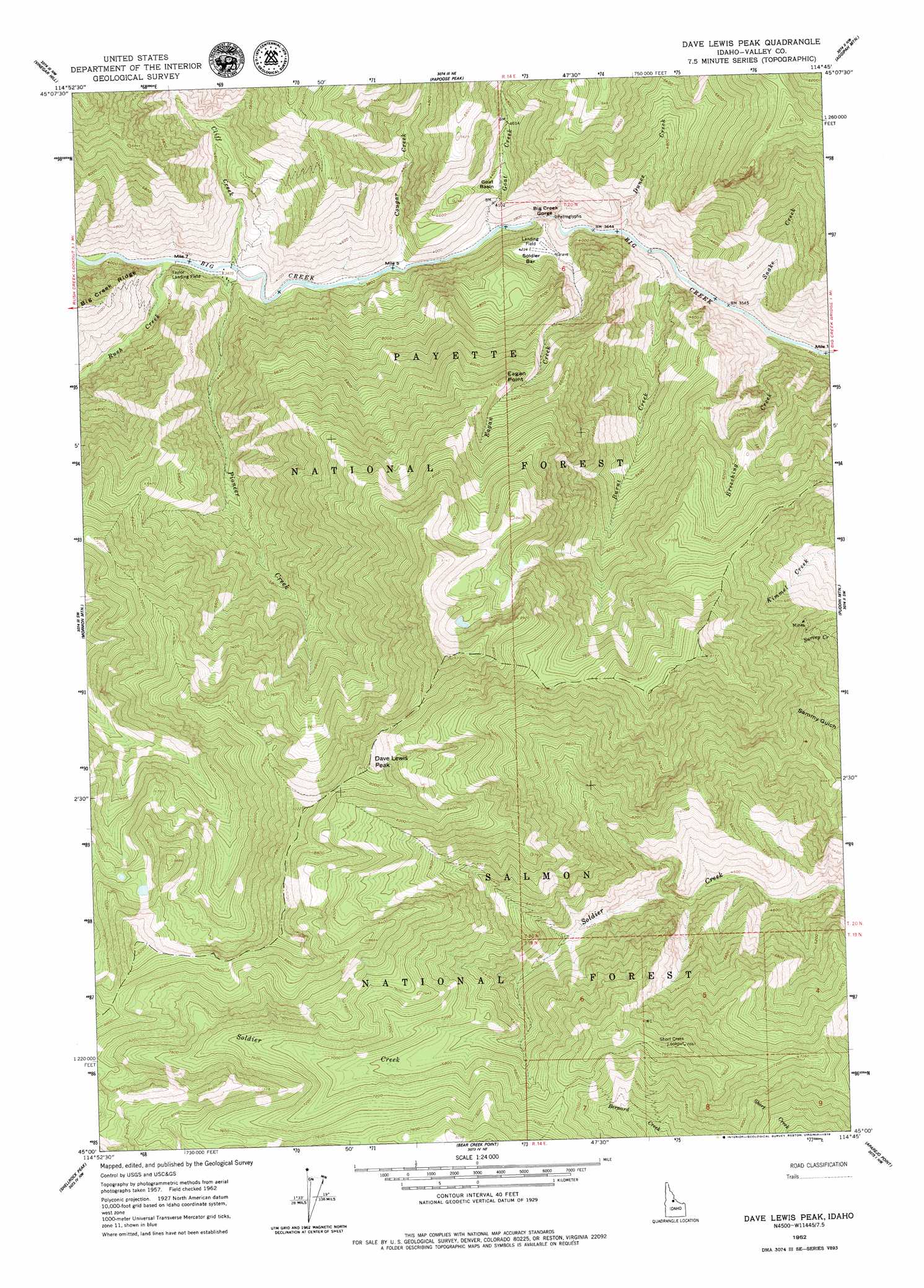
USGS Topo Quad 45114a7 - 1:24,000 scale
| Topo Map Name: | Dave Lewis Peak |
| USGS Topo Quad ID: | 45114a7 |
| Print Size: | ca. 21 1/4" wide x 27" high |
| Southeast Coordinates: | 45° N latitude / 114.75° W longitude |
| Map Center Coordinates: | 45.0625° N latitude / 114.8125° W longitude |
| U.S. State: | ID |
| Filename: | o45114a7.jpg |
| Download Map JPG Image: | Dave Lewis Peak topo map 1:24,000 scale |
| Map Type: | Topographic |
| Topo Series: | 7.5´ |
| Map Scale: | 1:24,000 |
| Source of Map Images: | United States Geological Survey (USGS) |
| Alternate Map Versions: |
Dave Lewis Peak ID 1962, updated 1964 Download PDF Buy paper map Dave Lewis Peak ID 1962, updated 1979 Download PDF Buy paper map Dave Lewis Peak ID 2004, updated 2007 Download PDF Buy paper map Dave Lewis Peak ID 2011 Download PDF Buy paper map Dave Lewis Peak ID 2013 Download PDF Buy paper map |
| FStopo: | US Forest Service topo Dave Lewis Peak is available: Download FStopo PDF Download FStopo TIF |
1:24,000 Topo Quads surrounding Dave Lewis Peak
Wapiti Creek |
Cold Meadows |
Cottonwood Butte |
Butts Creek Point |
Long Tom Mountain |
Acorn Butte |
Vinegar Hill |
Papoose Peak |
Aggipah Mountain |
Mount Mcguire |
Monument |
Mormon Mountain |
Dave Lewis Peak |
Puddin Mountain |
Hoodoo Meadows |
Safety Creek |
Shellrock Peak |
Bear Creek Point |
Aparejo Point |
Yellowjacket |
Pungo Mountain |
Norton Ridge |
Ramey Hill |
Sleeping Deer Mountain |
Meyers Cove |
> Back to 45114a1 at 1:100,000 scale
> Back to 45114a1 at 1:250,000 scale
> Back to U.S. Topo Maps home
Dave Lewis Peak topo map: Gazetteer
Dave Lewis Peak: Airports
Soldier Bar-US Forest Service Airport elevation 1289m 4229′Taylor Ranch Landing Area elevation 1166m 3825′
Dave Lewis Peak: Bars
Soldier Bar elevation 1288m 4225′Dave Lewis Peak: Basins
Goat Basin elevation 1330m 4363′Dave Lewis Peak: Streams
Breeching Creek elevation 1073m 3520′Burnt Creek elevation 1095m 3592′
Cliff Creek elevation 1174m 3851′
Cougar Creek elevation 1156m 3792′
Dunce Creek elevation 1106m 3628′
Eagan Creek elevation 1115m 3658′
Goat Creek elevation 1140m 3740′
Pioneer Creek elevation 1163m 3815′
Rush Creek elevation 1166m 3825′
Snake Creek elevation 1073m 3520′
Dave Lewis Peak: Summits
Dave Lewis Peak elevation 2815m 9235′Eagan Point elevation 2045m 6709′
Dave Lewis Peak: Valleys
Big Creek Gorge elevation 1119m 3671′Dave Lewis Peak digital topo map on disk
Buy this Dave Lewis Peak topo map showing relief, roads, GPS coordinates and other geographical features, as a high-resolution digital map file on DVD: