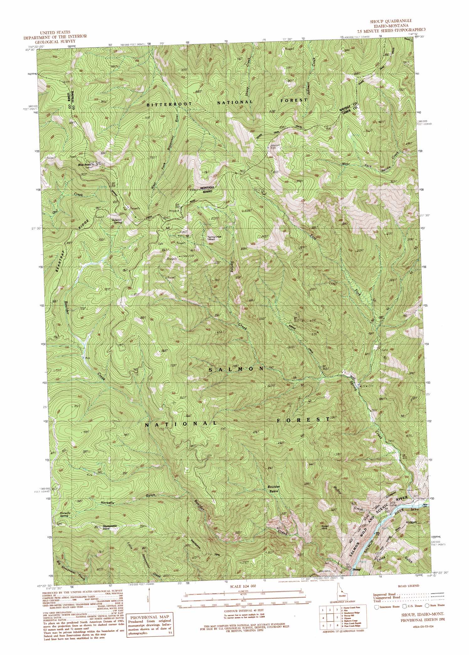
Shoup Topo Map Idaho
To zoom in, hover over the map of Shoup
USGS Topo Quad 45114d3 - 1:24,000 scale
| Topo Map Name: | Shoup |
| USGS Topo Quad ID: | 45114d3 |
| Print Size: | ca. 21 1/4" wide x 27" high |
| Southeast Coordinates: | 45.375° N latitude / 114.25° W longitude |
| Map Center Coordinates: | 45.4375° N latitude / 114.3125° W longitude |
| U.S. States: | ID, MT |
| Filename: | o45114d3.jpg |
| Download Map JPG Image: | Shoup topo map 1:24,000 scale |
| Map Type: | Topographic |
| Topo Series: | 7.5´ |
| Map Scale: | 1:24,000 |
| Source of Map Images: | United States Geological Survey (USGS) |
| Alternate Map Versions: |
Shoup ID 1991, updated 1991 Download PDF Buy paper map Shoup ID 1998, updated 2002 Download PDF Buy paper map Shoup ID 2011 Download PDF Buy paper map Shoup ID 2013 Download PDF Buy paper map |
| FStopo: | US Forest Service topo Shoup is available: Download FStopo PDF Download FStopo TIF |
1:24,000 Topo Quads surrounding Shoup
Nez Perce Peak |
Bare Cone |
Painted Rocks Lake |
Piquett Mountain |
Overwhich Falls |
Blue Joint |
Horse Creek Pass |
Alta |
Henderson Ridge |
Allan Mountain |
Horse Creek Butte |
Tincup Hill |
Shoup |
Ulysses |
Ulysses Mountain |
Long Tom Mountain |
Bighorn Crags |
Pine Creek Rapids |
Pine Creek Ridge |
Napoleon Hill |
Mount Mcguire |
Gant Ridge |
Gant Mountain |
Jureano Mountain |
Leesburg |
> Back to 45114a1 at 1:100,000 scale
> Back to 45114a1 at 1:250,000 scale
> Back to U.S. Topo Maps home
Shoup topo map: Gazetteer
Shoup: Basins
Boulder Basin elevation 1585m 5200′Shoup: Mines
Gregor Mine elevation 1391m 4563′Spring Creek Mines elevation 2358m 7736′
Shoup: Populated Places
Shoup elevation 1033m 3389′Shoup: Springs
Horsefly Spring elevation 2291m 7516′Valieaux Spring elevation 2463m 8080′
Shoup: Streams
Boulder Creek elevation 1032m 3385′East Fork Spring Creek elevation 1228m 4028′
McKay Creek elevation 1034m 3392′
Spring Creek elevation 1033m 3389′
Shoup: Summits
Blue Nose elevation 2634m 8641′Blue Nose elevation 2638m 8654′
Sheepeater Point elevation 2380m 7808′
Shoup: Trails
Divide Trail elevation 2477m 8126′Sheepeater Trail elevation 1772m 5813′
Shoup: Valleys
China Gulch elevation 1068m 3503′Horsefly Gulch elevation 1873m 6145′
Shoup digital topo map on disk
Buy this Shoup topo map showing relief, roads, GPS coordinates and other geographical features, as a high-resolution digital map file on DVD: