Devils Teeth Rapids Topo Map Idaho
To zoom in, hover over the map of Devils Teeth Rapids
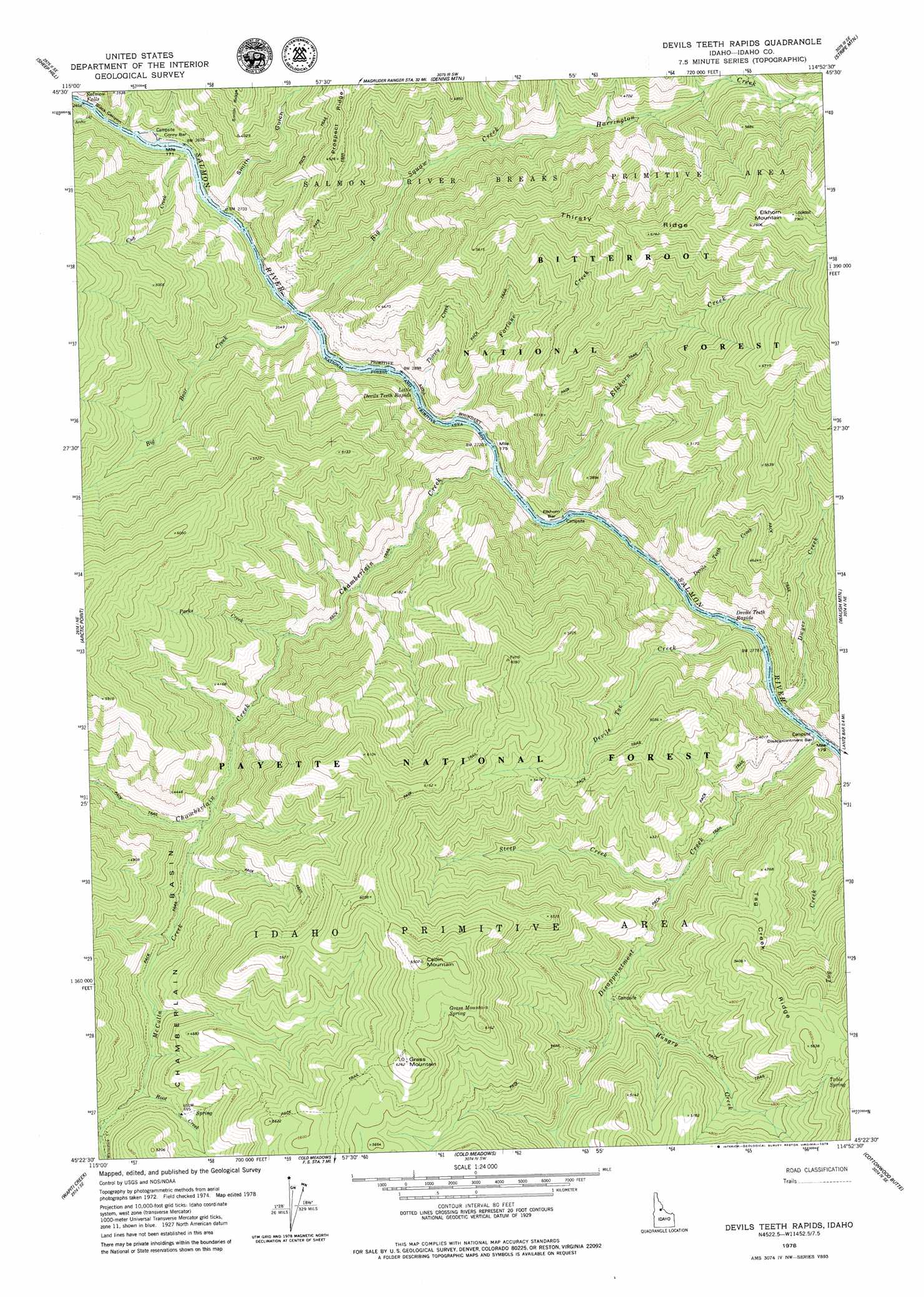
USGS Topo Quad 45114d8 - 1:24,000 scale
| Topo Map Name: | Devils Teeth Rapids |
| USGS Topo Quad ID: | 45114d8 |
| Print Size: | ca. 21 1/4" wide x 27" high |
| Southeast Coordinates: | 45.375° N latitude / 114.875° W longitude |
| Map Center Coordinates: | 45.4375° N latitude / 114.9375° W longitude |
| U.S. State: | ID |
| Filename: | o45114d8.jpg |
| Download Map JPG Image: | Devils Teeth Rapids topo map 1:24,000 scale |
| Map Type: | Topographic |
| Topo Series: | 7.5´ |
| Map Scale: | 1:24,000 |
| Source of Map Images: | United States Geological Survey (USGS) |
| Alternate Map Versions: |
Devils Teeth Rapids ID 1978, updated 1979 Download PDF Buy paper map Devils Teeth Rapids ID 1998, updated 2002 Download PDF Buy paper map Devils Teeth Rapids ID 2011 Download PDF Buy paper map Devils Teeth Rapids ID 2013 Download PDF Buy paper map |
| FStopo: | US Forest Service topo Devils Teeth Rapids is available: Download FStopo PDF Download FStopo TIF |
1:24,000 Topo Quads surrounding Devils Teeth Rapids
Boston Mountain |
Spread Creek Point |
Sabe Mountain |
Magruder Mountain |
Beaver Jack Mountain |
Hida Point |
Sheep Hill |
Dennis Mountain |
Stripe Mountain |
Wood Hump |
Meadow Of Doubt |
Arctic Point |
Devils Teeth Rapids |
Waugh Mountain |
Square Top |
Lodgepole Creek |
Wapiti Creek |
Cold Meadows |
Cottonwood Butte |
Butts Creek Point |
Bismark Mountain |
Acorn Butte |
Vinegar Hill |
Papoose Peak |
Aggipah Mountain |
> Back to 45114a1 at 1:100,000 scale
> Back to 45114a1 at 1:250,000 scale
> Back to U.S. Topo Maps home
Devils Teeth Rapids topo map: Gazetteer
Devils Teeth Rapids: Bars
Corey Bar elevation 825m 2706′Disappointment Bar elevation 854m 2801′
Elkhorn Bar elevation 851m 2791′
Devils Teeth Rapids: Falls
Salmon Falls elevation 816m 2677′Devils Teeth Rapids: Rapids
Devils Teeth Rapids elevation 837m 2746′Little Devils Teeth Rapids elevation 831m 2726′
Devils Teeth Rapids: Ridges
Tag Creek Ridge elevation 1639m 5377′Devils Teeth Rapids: Springs
Grass Mountain Spring elevation 1851m 6072′Table Spring elevation 1631m 5351′
Devils Teeth Rapids: Streams
Arctic Creek elevation 829m 2719′Big Bear Creek elevation 842m 2762′
Big Squaw Creek elevation 816m 2677′
Chamberlain Creek elevation 822m 2696′
Cub Creek elevation 824m 2703′
Devils Teeth Creek elevation 836m 2742′
Devils Toe Creek elevation 862m 2828′
Disappointment Creek elevation 848m 2782′
Dwyer Creek elevation 848m 2782′
Elkhorn Creek elevation 839m 2752′
Fortune Creek elevation 831m 2726′
Harrington Creek elevation 1043m 3421′
Hungry Creek elevation 1140m 3740′
McCalla Creek elevation 1033m 3389′
Parks Creek elevation 952m 3123′
Root Creek elevation 1223m 4012′
Steep Creek elevation 1051m 3448′
Thirst Creek elevation 826m 2709′
Whimstick Creek elevation 1243m 4078′
Devils Teeth Rapids: Summits
Cabin Mountain elevation 1981m 6499′Grass Mountain elevation 1892m 6207′
Patrol Point elevation 1818m 5964′
Devils Teeth Rapids: Valleys
Smith Gulch elevation 820m 2690′Devils Teeth Rapids digital topo map on disk
Buy this Devils Teeth Rapids topo map showing relief, roads, GPS coordinates and other geographical features, as a high-resolution digital map file on DVD: