Painted Rocks Lake Topo Map Montana
To zoom in, hover over the map of Painted Rocks Lake
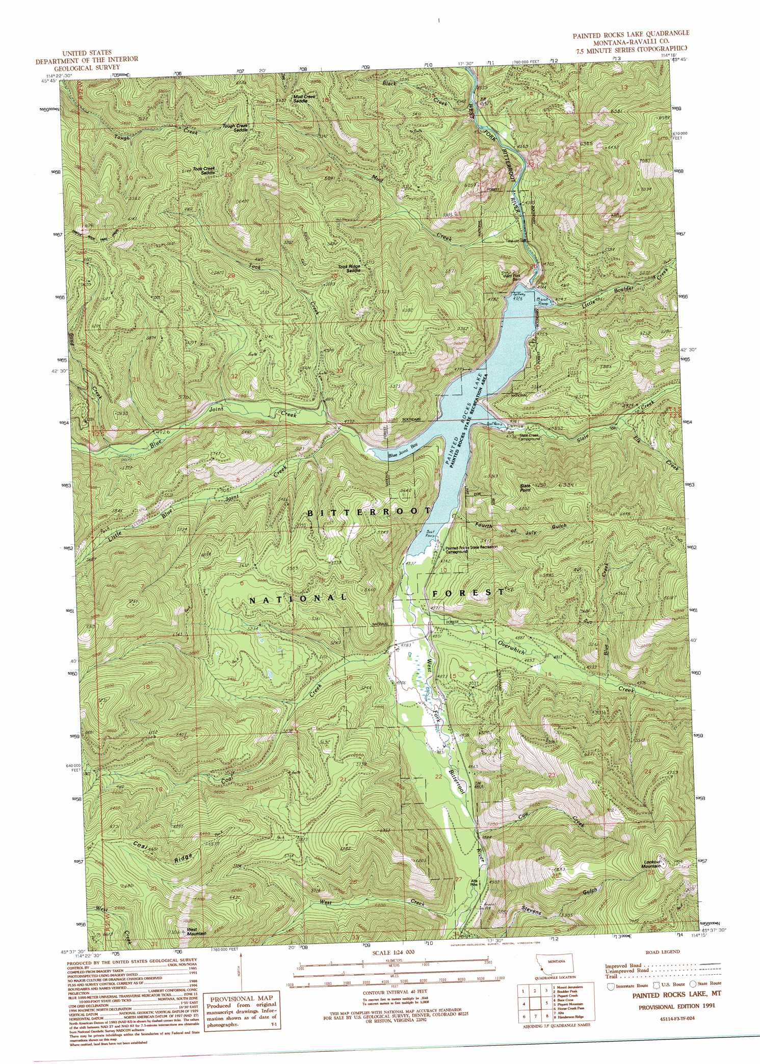
USGS Topo Quad 45114f3 - 1:24,000 scale
| Topo Map Name: | Painted Rocks Lake |
| USGS Topo Quad ID: | 45114f3 |
| Print Size: | ca. 21 1/4" wide x 27" high |
| Southeast Coordinates: | 45.625° N latitude / 114.25° W longitude |
| Map Center Coordinates: | 45.6875° N latitude / 114.3125° W longitude |
| U.S. State: | MT |
| Filename: | o45114f3.jpg |
| Download Map JPG Image: | Painted Rocks Lake topo map 1:24,000 scale |
| Map Type: | Topographic |
| Topo Series: | 7.5´ |
| Map Scale: | 1:24,000 |
| Source of Map Images: | United States Geological Survey (USGS) |
| Alternate Map Versions: |
Painted Rocks Lake MT 1991, updated 1991 Download PDF Buy paper map Painted Rocks Lake MT 1991, updated 1994 Download PDF Buy paper map Painted Rocks Lake MT 1998, updated 2002 Download PDF Buy paper map Painted Rocks Lake MT 2011 Download PDF Buy paper map Painted Rocks Lake MT 2014 Download PDF Buy paper map |
| FStopo: | US Forest Service topo Painted Rocks Lake is available: Download FStopo PDF Download FStopo TIF |
1:24,000 Topo Quads surrounding Painted Rocks Lake
Mount Paloma |
Tin Cup Lake |
Trapper Peak |
Burnt Ridge |
Robbins Gulch |
Watchtower Peak |
Mount Jerusalem |
Boulder Peak |
Piquett Creek |
Medicine Hot Springs |
Nez Perce Peak |
Bare Cone |
Painted Rocks Lake |
Piquett Mountain |
Overwhich Falls |
Blue Joint |
Horse Creek Pass |
Alta |
Henderson Ridge |
Allan Mountain |
Horse Creek Butte |
Tincup Hill |
Shoup |
Ulysses |
Ulysses Mountain |
> Back to 45114e1 at 1:100,000 scale
> Back to 45114a1 at 1:250,000 scale
> Back to U.S. Topo Maps home
Painted Rocks Lake topo map: Gazetteer
Painted Rocks Lake: Bays
Blue Joint Bay elevation 1441m 4727′Painted Rocks Lake: Dams
West Fork Dam elevation 1410m 4625′Painted Rocks Lake: Gaps
Mud Creek Saddle elevation 1774m 5820′Took Creek Saddle elevation 1777m 5830′
Took Ridge Saddle elevation 1743m 5718′
Tough Creek Saddle elevation 1832m 6010′
Painted Rocks Lake: Mines
SE SW Section 14 Mine elevation 1782m 5846′Painted Rocks Lake: Parks
Painted Rocks State Recreation Area elevation 1441m 4727′Painted Rocks Lake: Reservoirs
Painted Rocks Lake elevation 1410m 4625′Painted Rocks Lake: Springs
Hot Springs elevation 1502m 4927′Painted Rocks Lake: Streams
Black Creek elevation 1387m 4550′Blue Creek elevation 1512m 4960′
Blue Joint Creek elevation 1441m 4727′
Coal Creek elevation 1443m 4734′
Cow Creek elevation 1492m 4895′
Elk Creek elevation 1493m 4898′
Little Blue Joint Creek elevation 1448m 4750′
Little Boulder Creek elevation 1448m 4750′
Mud Creek elevation 1391m 4563′
Overwhich Creek elevation 1443m 4734′
Sand Creek elevation 1510m 4954′
Slate Creek elevation 1473m 4832′
Took Creek elevation 1453m 4767′
West Creek elevation 1496m 4908′
Painted Rocks Lake: Summits
Lookout Mountain elevation 2387m 7831′Slate Point elevation 1894m 6213′
West Mountain elevation 2216m 7270′
Painted Rocks Lake: Trails
Coal Ridge Trail elevation 1795m 5889′Lookout Mountain Trail elevation 2085m 6840′
Painted Rocks Lake: Valleys
Fourth of July Gulch elevation 1469m 4819′Stevens Gulch elevation 1585m 5200′
Painted Rocks Lake digital topo map on disk
Buy this Painted Rocks Lake topo map showing relief, roads, GPS coordinates and other geographical features, as a high-resolution digital map file on DVD: