Burnt Ridge Topo Map Montana
To zoom in, hover over the map of Burnt Ridge
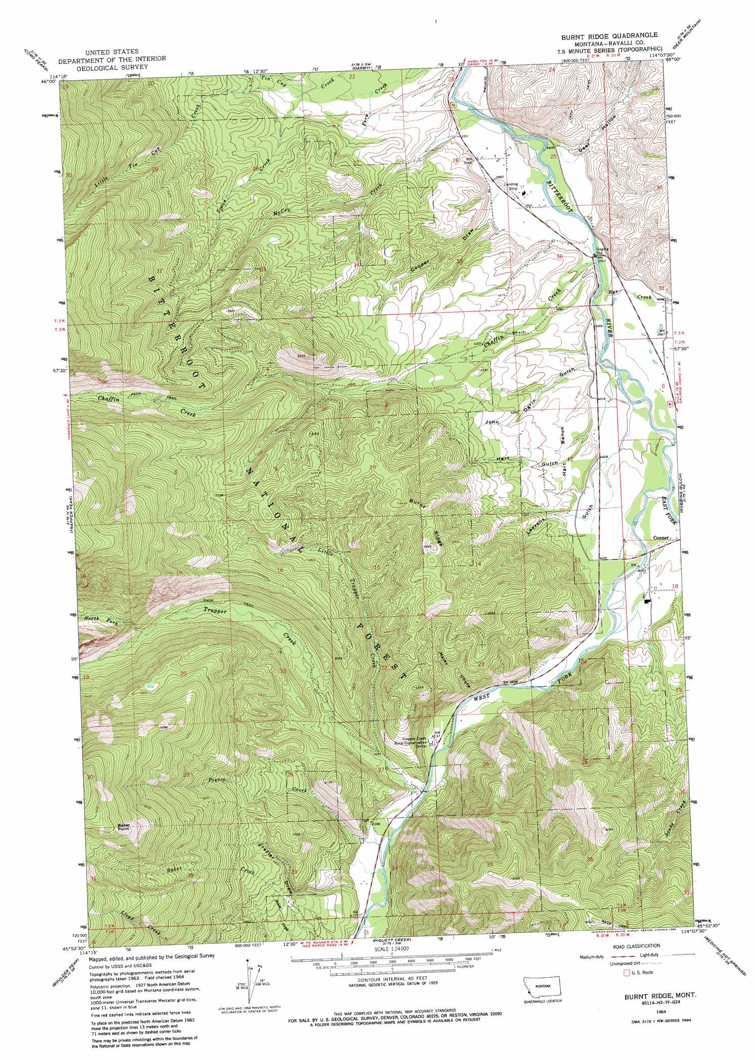
USGS Topo Quad 45114h2 - 1:24,000 scale
| Topo Map Name: | Burnt Ridge |
| USGS Topo Quad ID: | 45114h2 |
| Print Size: | ca. 21 1/4" wide x 27" high |
| Southeast Coordinates: | 45.875° N latitude / 114.125° W longitude |
| Map Center Coordinates: | 45.9375° N latitude / 114.1875° W longitude |
| U.S. State: | MT |
| Filename: | o45114h2.jpg |
| Download Map JPG Image: | Burnt Ridge topo map 1:24,000 scale |
| Map Type: | Topographic |
| Topo Series: | 7.5´ |
| Map Scale: | 1:24,000 |
| Source of Map Images: | United States Geological Survey (USGS) |
| Alternate Map Versions: |
Burnt Ridge MT 1964, updated 1968 Download PDF Buy paper map Burnt Ridge MT 1964, updated 1981 Download PDF Buy paper map Burnt Ridge MT 1964, updated 1986 Download PDF Buy paper map Burnt Ridge MT 1964, updated 1986 Download PDF Buy paper map Burnt Ridge MT 1998, updated 2002 Download PDF Buy paper map Burnt Ridge MT 2011 Download PDF Buy paper map Burnt Ridge MT 2014 Download PDF Buy paper map |
| FStopo: | US Forest Service topo Burnt Ridge is available: Download FStopo PDF Download FStopo TIF |
1:24,000 Topo Quads surrounding Burnt Ridge
Tenmile Lake |
Ward Mountain |
Hamilton South |
Mountain House |
Gird Point |
El Capitan |
Como Peaks |
Darby |
Deer Mountain |
Bald Top Mountain |
Tin Cup Lake |
Trapper Peak |
Burnt Ridge |
Robbins Gulch |
French Basin |
Mount Jerusalem |
Boulder Peak |
Piquett Creek |
Medicine Hot Springs |
Sula |
Bare Cone |
Painted Rocks Lake |
Piquett Mountain |
Overwhich Falls |
Lost Trail Pass |
> Back to 45114e1 at 1:100,000 scale
> Back to 45114a1 at 1:250,000 scale
> Back to U.S. Topo Maps home
Burnt Ridge topo map: Gazetteer
Burnt Ridge: Airports
Trapper Creek Strip elevation 1240m 4068′Burnt Ridge: Benches
Hart Bench elevation 1264m 4146′Burnt Ridge: Capes
Baker Point elevation 2250m 7381′Burnt Ridge: Mines
Rocci Mine elevation 1452m 4763′Burnt Ridge: Populated Places
Peaks and Pines Park elevation 1213m 3979′Burnt Ridge: Ridges
Burnt Ridge elevation 1593m 5226′Burnt Ridge: Streams
Chaffin Creek elevation 1212m 3976′East Fork Bitterroot River elevation 1223m 4012′
Little Tin Cup Creek elevation 1249m 4097′
Little Trapper Creek elevation 1293m 4242′
McCoy Creek elevation 1202m 3943′
North Fork Trapper Creek elevation 1432m 4698′
Pierce Creek elevation 1270m 4166′
Rye Creek elevation 1205m 3953′
Spoon Creek elevation 1248m 4094′
Trapper Creek elevation 1261m 4137′
West Fork Bitterroot River elevation 1223m 4012′
Burnt Ridge: Summits
Grouse Butte elevation 1687m 5534′Burnt Ridge: Valleys
Cooper Draw elevation 1215m 3986′Deer Hollow elevation 1195m 3920′
Frazier Draw elevation 1284m 4212′
Haley Chute elevation 1255m 4117′
Hart Gulch elevation 1217m 3992′
John Ogrin Gulch elevation 1218m 3996′
Leavens Gulch elevation 1213m 3979′
Burnt Ridge: Wells
02N20W07BCCC01 Well elevation 1242m 4074′02N21W12CDBA01 Well elevation 1275m 4183′
02N21W12DCAC01 Well elevation 1238m 4061′
02N21W34CBD_01 Well elevation 1271m 4169′
02N21W34CDAC01 Well elevation 1272m 4173′
03N20W31DBBC01 Well elevation 1225m 4019′
03N20W31DBCC01 Well elevation 1210m 3969′
03N21W26BBB_01 Well elevation 1251m 4104′
Burnt Ridge digital topo map on disk
Buy this Burnt Ridge topo map showing relief, roads, GPS coordinates and other geographical features, as a high-resolution digital map file on DVD: