Elk City Topo Map Idaho
To zoom in, hover over the map of Elk City
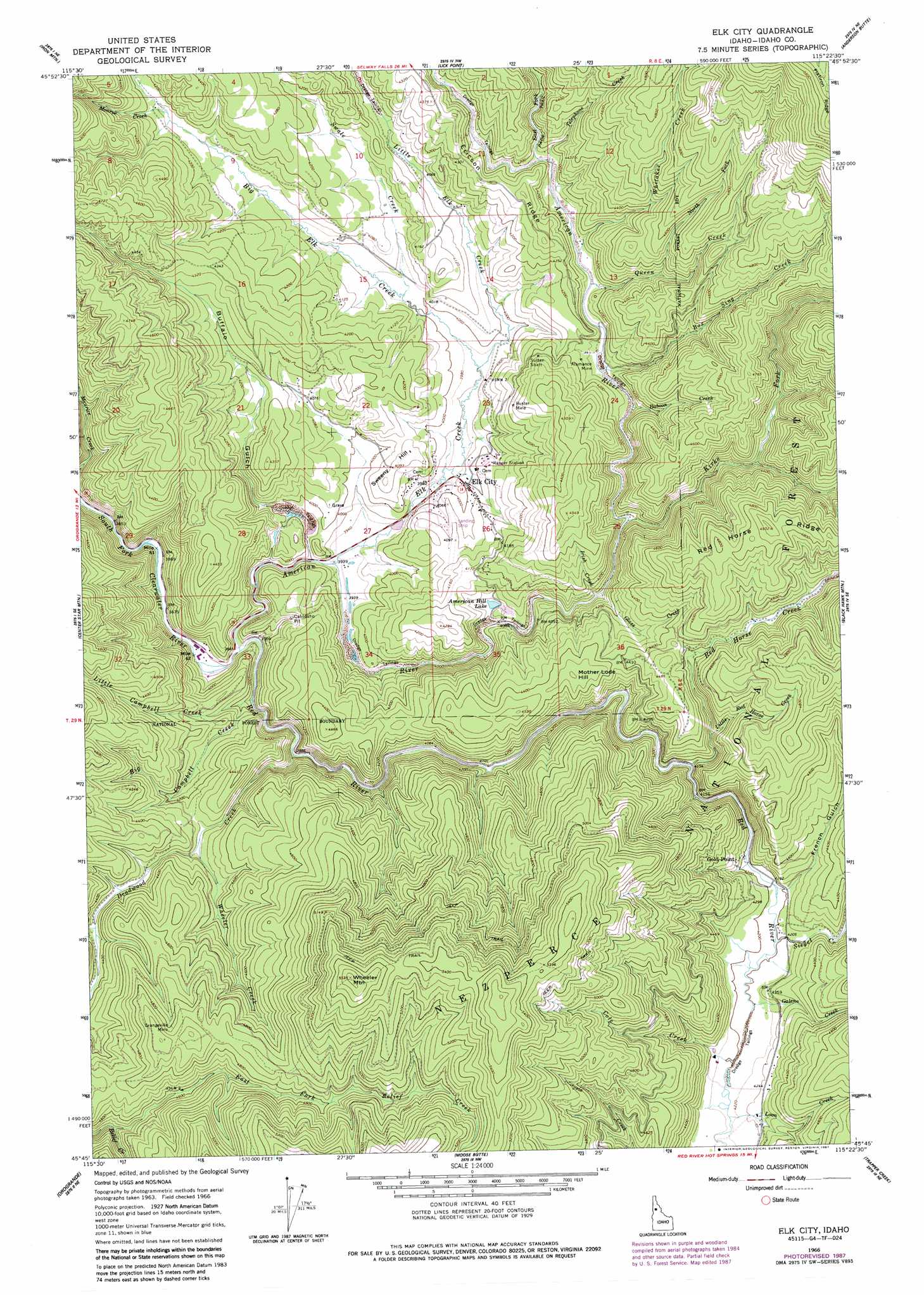
USGS Topo Quad 45115g4 - 1:24,000 scale
| Topo Map Name: | Elk City |
| USGS Topo Quad ID: | 45115g4 |
| Print Size: | ca. 21 1/4" wide x 27" high |
| Southeast Coordinates: | 45.75° N latitude / 115.375° W longitude |
| Map Center Coordinates: | 45.8125° N latitude / 115.4375° W longitude |
| U.S. State: | ID |
| Filename: | o45115g4.jpg |
| Download Map JPG Image: | Elk City topo map 1:24,000 scale |
| Map Type: | Topographic |
| Topo Series: | 7.5´ |
| Map Scale: | 1:24,000 |
| Source of Map Images: | United States Geological Survey (USGS) |
| Alternate Map Versions: |
Elk City ID 1966, updated 1968 Download PDF Buy paper map Elk City ID 1966, updated 1979 Download PDF Buy paper map Elk City ID 1966, updated 1987 Download PDF Buy paper map Elk City ID 1995, updated 1999 Download PDF Buy paper map Elk City ID 2011 Download PDF Buy paper map Elk City ID 2013 Download PDF Buy paper map |
| FStopo: | US Forest Service topo Elk City is available: Download FStopo PDF Download FStopo TIF |
1:24,000 Topo Quads surrounding Elk City
Lodge Point |
Goddard Point |
Stillman Point |
Selway Falls |
Fog Mountain |
Pilot Knob |
Iron Mountain |
Lick Point |
Anderson Butte |
Vermilion Peak |
Golden |
Cener Star Mountain |
Elk City |
Black Hawk Mountain |
Sable Hill |
North Pole |
Orogrande |
Moose Butte |
Trapper Creek |
Boston Mountain |
Buffalo Hump |
Silver Spur Ridge |
Dixie |
Whitewater Ranch |
Hida Point |
> Back to 45115e1 at 1:100,000 scale
> Back to 45114a1 at 1:250,000 scale
> Back to U.S. Topo Maps home
Elk City topo map: Gazetteer
Elk City: Airports
Elk City Airport elevation 1245m 4084′Elk City: Lakes
American Hill Lake elevation 1230m 4035′Elk City: Mines
Alamance Mine elevation 1267m 4156′Buster Mine elevation 1294m 4245′
Cal-Idaho Pit elevation 1227m 4025′
Gold Point Mine elevation 1306m 4284′
Grangeville Mine elevation 1462m 4796′
Sultan Shaft elevation 1288m 4225′
Elk City: Populated Places
Elk City elevation 1221m 4005′Gold Point elevation 1301m 4268′
Elk City: Ridges
Red Horse Ridge elevation 1498m 4914′Elk City: Streams
American River elevation 1189m 3900′Baboon Creek elevation 1243m 4078′
Big Campbell Creek elevation 1195m 3920′
Big Elk Creek elevation 1209m 3966′
Box Sing Creek elevation 1252m 4107′
Cole Creek elevation 1281m 4202′
Deadwood Creek elevation 1217m 3992′
East Fork American River elevation 1266m 4153′
East Fork Relief Creek elevation 1364m 4475′
Elk Creek elevation 1204m 3950′
Galena Creek elevation 1282m 4206′
Glass Creek elevation 1240m 4068′
Irish Creek elevation 1245m 4084′
Kirks Fork elevation 1242m 4074′
Little Campbell Creek elevation 1219m 3999′
Little Elk Creek elevation 1209m 3966′
Little Red Horse Creek elevation 1303m 4274′
Loon Creek elevation 1287m 4222′
Monroe Creek elevation 1267m 4156′
North Fork Queen Creek elevation 1306m 4284′
Queen Creek elevation 1253m 4110′
Red Horse Creek elevation 1268m 4160′
Red River elevation 1190m 3904′
Siegel Creek elevation 1281m 4202′
Swale Creek elevation 1223m 4012′
Telephone Creek elevation 1261m 4137′
Wheeler Creek elevation 1293m 4242′
Whitaker Creek elevation 1253m 4110′
Elk City: Summits
Mother Lode Hill elevation 1366m 4481′Sweeny Hill elevation 1256m 4120′
Wheeler Mountain elevation 1686m 5531′
Elk City: Valleys
Buffalo Gulch elevation 1203m 3946′French Gulch elevation 1279m 4196′
Elk City digital topo map on disk
Buy this Elk City topo map showing relief, roads, GPS coordinates and other geographical features, as a high-resolution digital map file on DVD: