Cener Star Mountain Topo Map Idaho
To zoom in, hover over the map of Cener Star Mountain
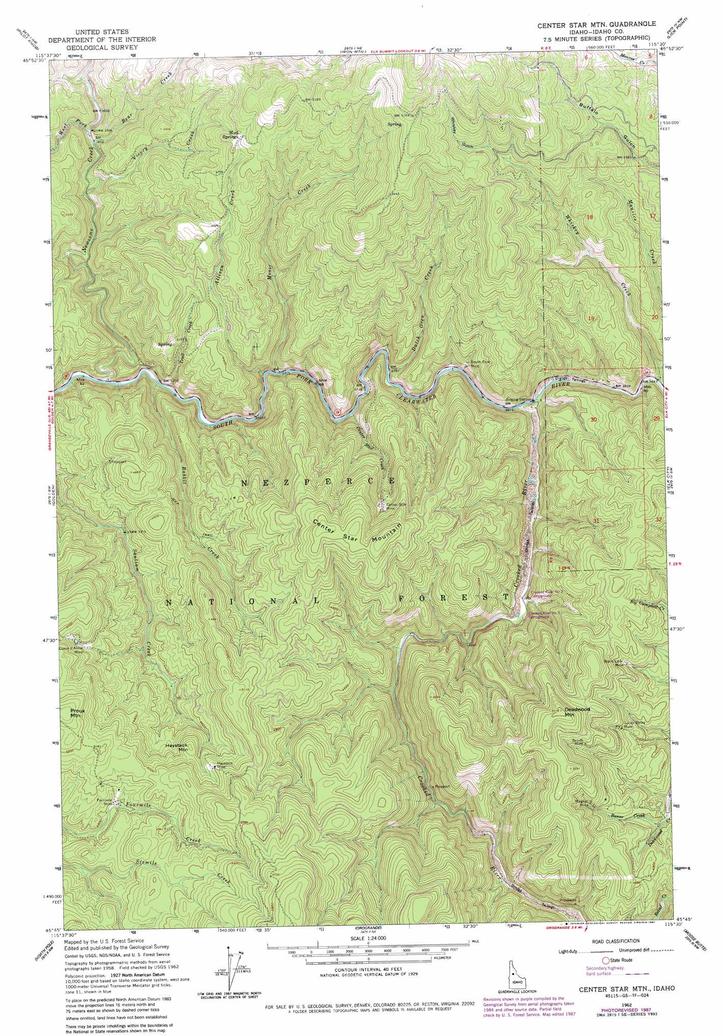
USGS Topo Quad 45115g5 - 1:24,000 scale
| Topo Map Name: | Cener Star Mountain |
| USGS Topo Quad ID: | 45115g5 |
| Print Size: | ca. 21 1/4" wide x 27" high |
| Southeast Coordinates: | 45.75° N latitude / 115.5° W longitude |
| Map Center Coordinates: | 45.8125° N latitude / 115.5625° W longitude |
| U.S. State: | ID |
| Filename: | o45115g5.jpg |
| Download Map JPG Image: | Cener Star Mountain topo map 1:24,000 scale |
| Map Type: | Topographic |
| Topo Series: | 7.5´ |
| Map Scale: | 1:24,000 |
| Source of Map Images: | United States Geological Survey (USGS) |
| Alternate Map Versions: |
Center Star Mtn ID 1962, updated 1964 Download PDF Buy paper map Center Star Mtn ID 1962, updated 1981 Download PDF Buy paper map Center Star Mtn ID 1962, updated 1984 Download PDF Buy paper map Center Star Mtn ID 1962, updated 1987 Download PDF Buy paper map Center Star Mountain ID 1995, updated 1999 Download PDF Buy paper map Center Star Mountain ID 2011 Download PDF Buy paper map Center Star Mountain ID 2013 Download PDF Buy paper map |
| FStopo: | US Forest Service topo Center Star Mountain is available: Download FStopo PDF Download FStopo TIF |
1:24,000 Topo Quads surrounding Cener Star Mountain
Big Cedar |
Lodge Point |
Goddard Point |
Stillman Point |
Selway Falls |
Corral Hill |
Pilot Knob |
Iron Mountain |
Lick Point |
Anderson Butte |
Huddleson Bluff |
Golden |
Cener Star Mountain |
Elk City |
Black Hawk Mountain |
Sourdough Peak |
North Pole |
Orogrande |
Moose Butte |
Trapper Creek |
Marble Butte |
Buffalo Hump |
Silver Spur Ridge |
Dixie |
Whitewater Ranch |
> Back to 45115e1 at 1:100,000 scale
> Back to 45114a1 at 1:250,000 scale
> Back to U.S. Topo Maps home
Cener Star Mountain topo map: Gazetteer
Cener Star Mountain: Mines
Black Lady Mine elevation 1422m 4665′Center Star Mine elevation 1431m 4694′
Coeur d'Alene Mine elevation 1459m 4786′
Fourmile Mine elevation 1452m 4763′
Golden Fleece Mine elevation 1279m 4196′
Haystack Mine elevation 1523m 4996′
Idaho Champion Group Prospects elevation 1444m 4737′
Lucky Strike Mine elevation 1449m 4753′
South Fork Mine elevation 1234m 4048′
Wagner Mine elevation 1482m 4862′
Zenith Mine elevation 1533m 5029′
Cener Star Mountain: Populated Places
Mud Springs elevation 1467m 4812′Cener Star Mountain: Streams
Allison Creek elevation 1139m 3736′Baner Creek elevation 1365m 4478′
Bear Creek elevation 1182m 3877′
Center Star Creek elevation 1164m 3818′
Crooked River elevation 1164m 3818′
Dutch Oven Creek elevation 1153m 3782′
Maurice Creek elevation 1274m 4179′
Moose Creek elevation 1144m 3753′
Newsome Creek elevation 1104m 3622′
Rabbit Creek elevation 1105m 3625′
Trail Creek elevation 1131m 3710′
Vicory Creek elevation 1188m 3897′
West Fork Newsome Creek elevation 1176m 3858′
Whiskey Creek elevation 1195m 3920′
Cener Star Mountain: Summits
Center Star Mountain elevation 1612m 5288′Deadwood Mountain elevation 1650m 5413′
Haystack Mountain elevation 1515m 4970′
Proux Mountain elevation 1640m 5380′
Cener Star Mountain: Valleys
The Narrows elevation 1177m 3861′Whiskey Gulch elevation 1547m 5075′
Cener Star Mountain digital topo map on disk
Buy this Cener Star Mountain topo map showing relief, roads, GPS coordinates and other geographical features, as a high-resolution digital map file on DVD: