Pilot Knob Topo Map Idaho
To zoom in, hover over the map of Pilot Knob
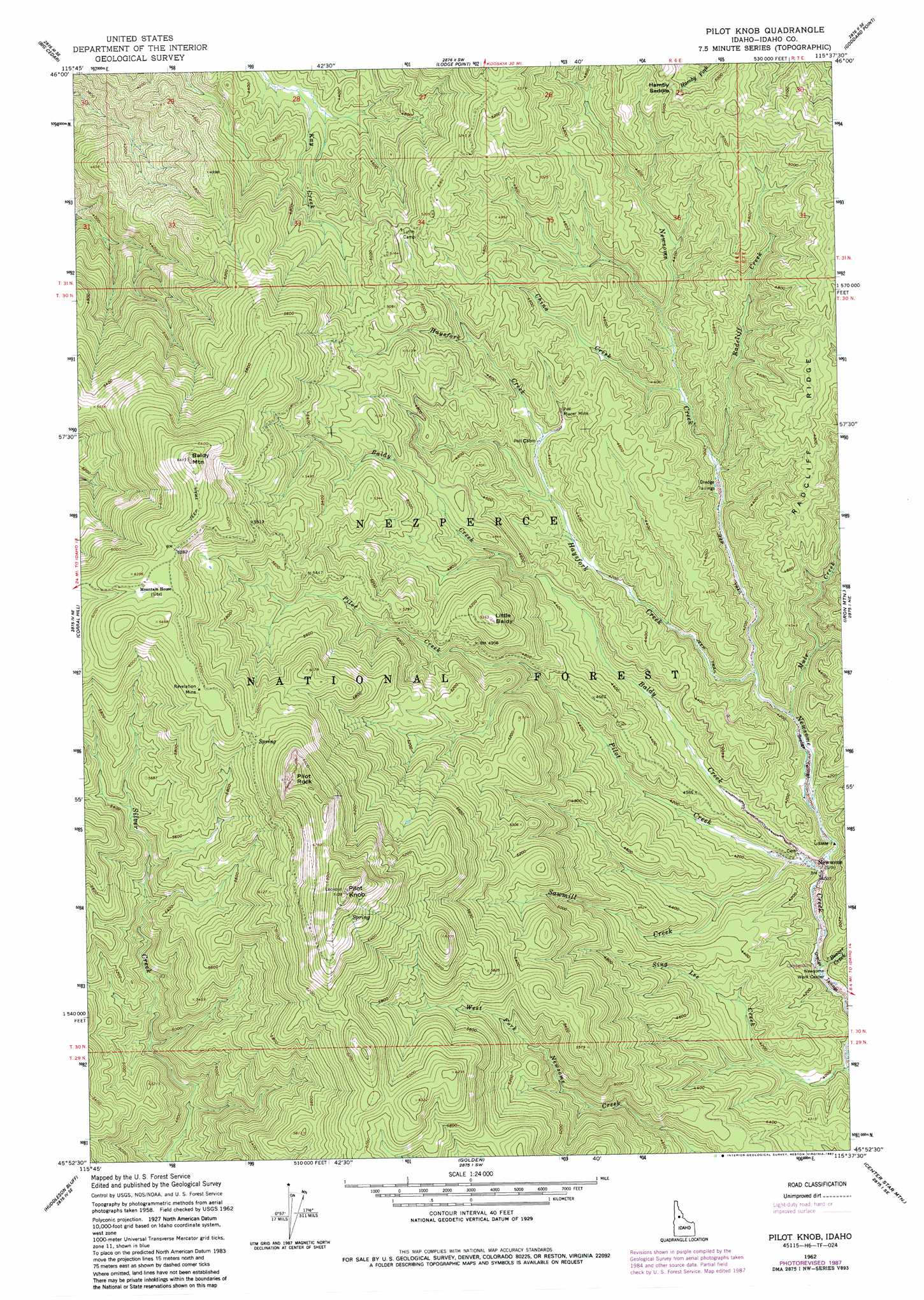
USGS Topo Quad 45115h6 - 1:24,000 scale
| Topo Map Name: | Pilot Knob |
| USGS Topo Quad ID: | 45115h6 |
| Print Size: | ca. 21 1/4" wide x 27" high |
| Southeast Coordinates: | 45.875° N latitude / 115.625° W longitude |
| Map Center Coordinates: | 45.9375° N latitude / 115.6875° W longitude |
| U.S. State: | ID |
| Filename: | o45115h6.jpg |
| Download Map JPG Image: | Pilot Knob topo map 1:24,000 scale |
| Map Type: | Topographic |
| Topo Series: | 7.5´ |
| Map Scale: | 1:24,000 |
| Source of Map Images: | United States Geological Survey (USGS) |
| Alternate Map Versions: |
Pilot Knob ID 1962, updated 1964 Download PDF Buy paper map Pilot Knob ID 1962, updated 1983 Download PDF Buy paper map Pilot Knob ID 1962, updated 1987 Download PDF Buy paper map Pilot Knob ID 1995, updated 1999 Download PDF Buy paper map Pilot Knob ID 2011 Download PDF Buy paper map Pilot Knob ID 2013 Download PDF Buy paper map |
| FStopo: | US Forest Service topo Pilot Knob is available: Download FStopo PDF Download FStopo TIF |
1:24,000 Topo Quads surrounding Pilot Knob
Kooskia |
Glenwood |
Syringa |
Lowell |
Coolwater Mountain |
Stites |
Big Cedar |
Lodge Point |
Goddard Point |
Stillman Point |
Harpster |
Corral Hill |
Pilot Knob |
Iron Mountain |
Lick Point |
Hungry Ridge |
Huddleson Bluff |
Golden |
Cener Star Mountain |
Elk City |
Sawyer Ridge |
Sourdough Peak |
North Pole |
Orogrande |
Moose Butte |
> Back to 45115e1 at 1:100,000 scale
> Back to 45114a1 at 1:250,000 scale
> Back to U.S. Topo Maps home
Pilot Knob topo map: Gazetteer
Pilot Knob: Gaps
Hamby Saddle elevation 1530m 5019′Pilot Knob: Mines
Pell Placer Mine elevation 1335m 4379′Revelation Mine elevation 1909m 6263′
Pilot Knob: Populated Places
Newsome elevation 1225m 4019′Pilot Knob: Ridges
Radcliff Ridge elevation 1550m 5085′Pilot Knob: Streams
Baldy Creek elevation 1228m 4028′Beaver Creek elevation 1215m 3986′
China Creek elevation 1290m 4232′
Haysfork Creek elevation 1250m 4101′
Mule Creek elevation 1250m 4101′
Pilot Creek elevation 1229m 4032′
Radcliff Creek elevation 1268m 4160′
Sawmill Creek elevation 1230m 4035′
Sing Lee Creek elevation 1204m 3950′
Pilot Knob: Summits
Baldy Mountain elevation 2015m 6610′Little Baldy elevation 1637m 5370′
Pilot Knob elevation 2171m 7122′
Pilot Rock elevation 2110m 6922′
Pilot Knob: Trails
Pilot Knob Trail elevation 1928m 6325′Pilot Knob digital topo map on disk
Buy this Pilot Knob topo map showing relief, roads, GPS coordinates and other geographical features, as a high-resolution digital map file on DVD: