Grave Point Topo Map Idaho
To zoom in, hover over the map of Grave Point
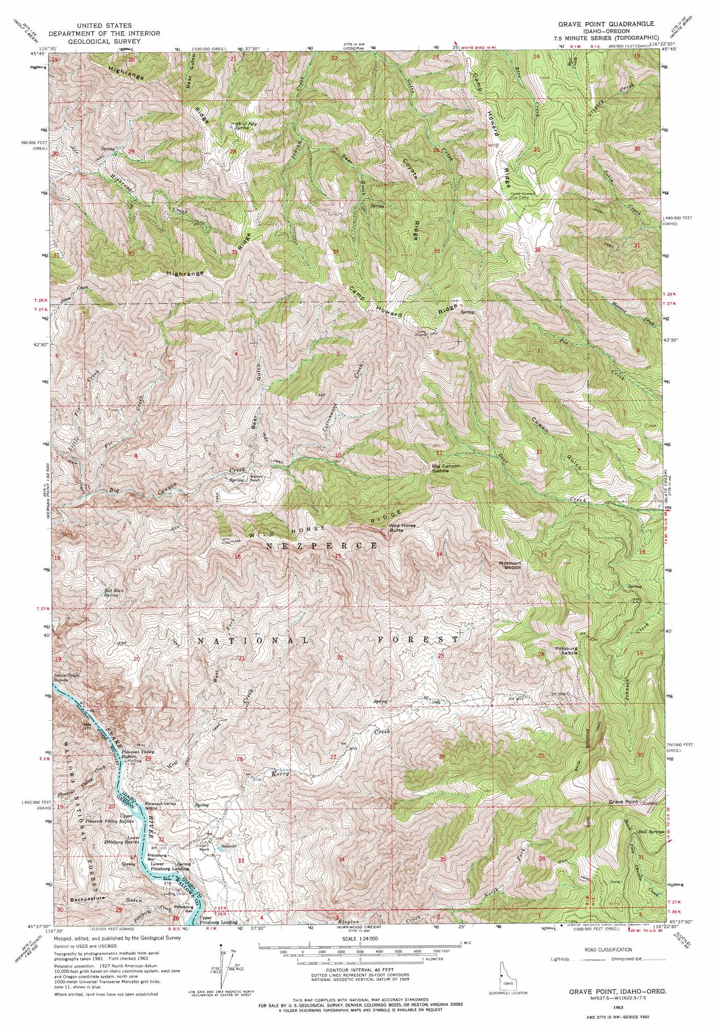
USGS Topo Quad 45116f4 - 1:24,000 scale
| Topo Map Name: | Grave Point |
| USGS Topo Quad ID: | 45116f4 |
| Print Size: | ca. 21 1/4" wide x 27" high |
| Southeast Coordinates: | 45.625° N latitude / 116.375° W longitude |
| Map Center Coordinates: | 45.6875° N latitude / 116.4375° W longitude |
| U.S. States: | ID, OR |
| Filename: | o45116f4.jpg |
| Download Map JPG Image: | Grave Point topo map 1:24,000 scale |
| Map Type: | Topographic |
| Topo Series: | 7.5´ |
| Map Scale: | 1:24,000 |
| Source of Map Images: | United States Geological Survey (USGS) |
| Alternate Map Versions: |
Grave Point ID 1963, updated 1965 Download PDF Buy paper map Grave Point ID 1963, updated 1977 Download PDF Buy paper map Grave Point ID 1995, updated 1999 Download PDF Buy paper map Grave Point ID 2011 Download PDF Buy paper map Grave Point ID 2013 Download PDF Buy paper map |
| FStopo: | US Forest Service topo Grave Point is available: Download FStopo PDF Download FStopo TIF |
1:24,000 Topo Quads surrounding Grave Point
Rattlesnake Ridge |
Boles |
Moughmer Point |
Fenn |
Grangeville West |
Cactus Mountain |
Wolf Creek |
Joseph |
White Bird |
White Bird Hill |
Fingerboard Saddle |
Lord Flat |
Grave Point |
Slate Creek |
Mckinzie Creek |
Sleepy Ridge |
Temperance Creek |
Kirkwood Creek |
Lucile |
John Day Mountain |
Hat Point |
Old Time Mountain |
Kessler Creek |
Riggins |
Riggins Hot Springs |
> Back to 45116e1 at 1:100,000 scale
> Back to 45116a1 at 1:250,000 scale
> Back to U.S. Topo Maps home
Grave Point topo map: Gazetteer
Grave Point: Bars
Pittsburg Bar elevation 346m 1135′Pittsburg Bar elevation 350m 1148′
Grave Point: Gaps
Big Canyon Saddle elevation 1496m 4908′Motthorn Saddle elevation 1337m 4386′
Pittsburg Saddle elevation 1308m 4291′
Grave Point: Islands
Pleasant Valley Island elevation 349m 1145′Grave Point: Populated Places
Taylor elevation 965m 3166′Grave Point: Rapids
Lower Pittsburg Rapids elevation 344m 1128′Lower Pittsburg Rapids elevation 344m 1128′
Middle Pittsburg Rapids elevation 347m 1138′
Pleasant Valley Rapids elevation 337m 1105′
Pleasant Valley Rapids elevation 337m 1105′
Upper Pleasant Valley Rapids elevation 343m 1125′
Upper Pleasant Valley Rapids elevation 343m 1125′
Grave Point: Ridges
Camp Howard Ridge elevation 1735m 5692′Coyote Ridge elevation 1584m 5196′
Highrange Ridge elevation 1543m 5062′
Wild Horse Ridge elevation 1286m 4219′
Grave Point: Springs
Bull Springs elevation 1524m 5000′Fourth of July Spring elevation 1351m 4432′
Red Rock Spring elevation 805m 2641′
Grave Point: Streams
Cottonwood Creek elevation 1036m 3398′Fir Creek elevation 602m 1975′
Indian Creek elevation 1065m 3494′
Kurry Creek elevation 357m 1171′
Little Fir Creek elevation 587m 1925′
North Fork Klopton Creek elevation 856m 2808′
Pittsburg Creek elevation 355m 1164′
Pleasant Valley Creek elevation 340m 1115′
West Creek elevation 340m 1115′
West Fork West Creek elevation 455m 1492′
Grave Point: Summits
Grave Point elevation 1712m 5616′Wild Horse Butte elevation 1616m 5301′
Grave Point: Valleys
Bear Gulch elevation 902m 2959′Buckpasture Gulch elevation 416m 1364′
Cowen Gulch elevation 940m 3083′
Deer Gulch elevation 1224m 4015′
Grand Canyon of the Snake River elevation 681m 2234′
Grave Point digital topo map on disk
Buy this Grave Point topo map showing relief, roads, GPS coordinates and other geographical features, as a high-resolution digital map file on DVD: