Flagstaff Butte Topo Map Oregon
To zoom in, hover over the map of Flagstaff Butte
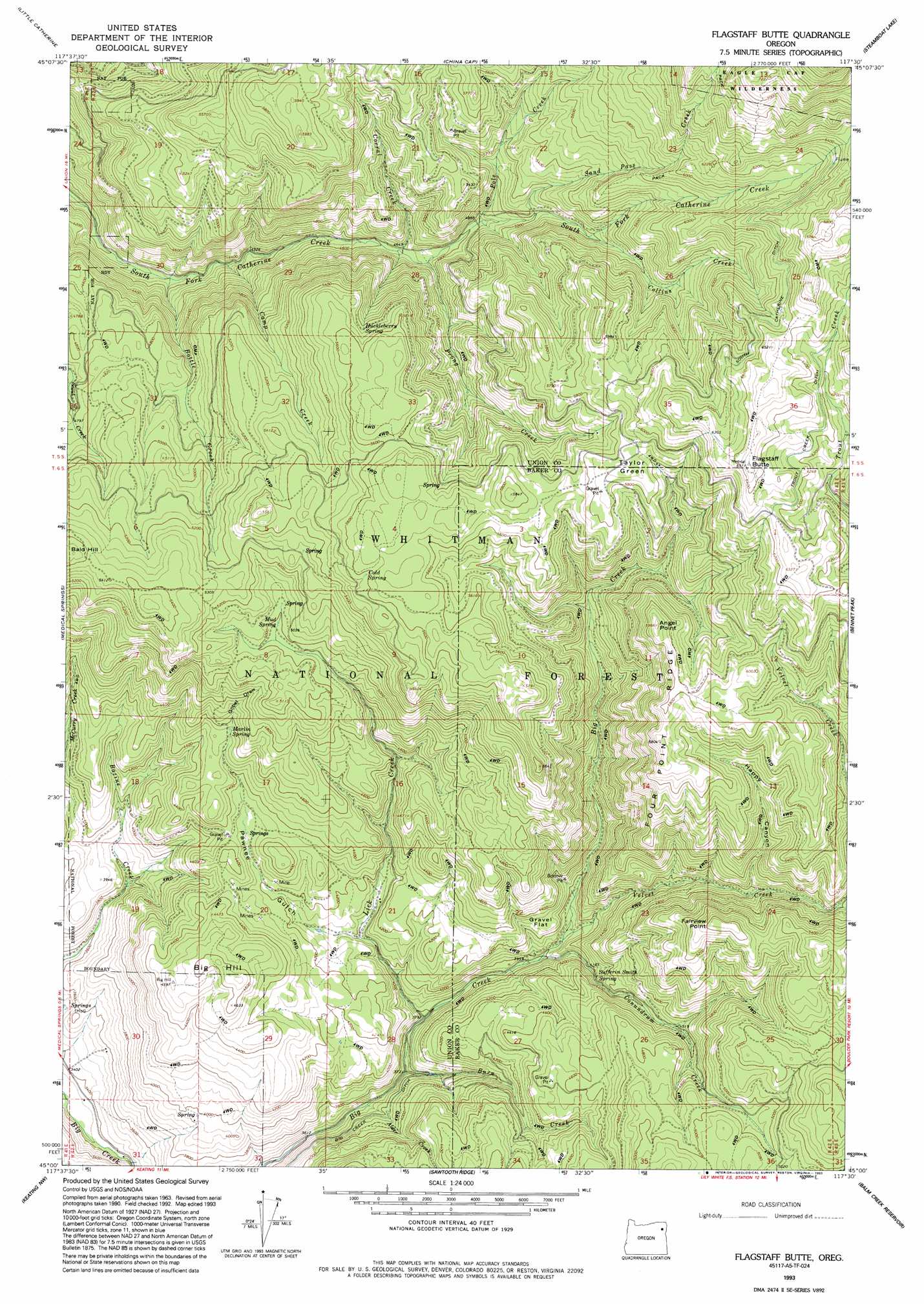
USGS Topo Quad 45117a5 - 1:24,000 scale
| Topo Map Name: | Flagstaff Butte |
| USGS Topo Quad ID: | 45117a5 |
| Print Size: | ca. 21 1/4" wide x 27" high |
| Southeast Coordinates: | 45° N latitude / 117.5° W longitude |
| Map Center Coordinates: | 45.0625° N latitude / 117.5625° W longitude |
| U.S. State: | OR |
| Filename: | o45117a5.jpg |
| Download Map JPG Image: | Flagstaff Butte topo map 1:24,000 scale |
| Map Type: | Topographic |
| Topo Series: | 7.5´ |
| Map Scale: | 1:24,000 |
| Source of Map Images: | United States Geological Survey (USGS) |
| Alternate Map Versions: |
Flagstaff Butte OR 1965, updated 1967 Download PDF Buy paper map Flagstaff Butte OR 1965, updated 1985 Download PDF Buy paper map Flagstaff Butte OR 1993, updated 1993 Download PDF Buy paper map Flagstaff Butte OR 2011 Download PDF Buy paper map Flagstaff Butte OR 2014 Download PDF Buy paper map |
| FStopo: | US Forest Service topo Flagstaff Butte is available: Download FStopo PDF Download FStopo TIF |
1:24,000 Topo Quads surrounding Flagstaff Butte
Cove |
Mount Fanny |
Jim White Ridge |
North Minam Meadows |
Chief Joseph Mountain |
Union |
Little Catherine Creek |
China Cap |
Steamboat Lake |
Eagle Cap |
Telocaset |
Medical Springs |
Flagstaff Butte |
Bennet Peak |
Krag Peak |
Magpie Peak |
Keating Nw |
Sawtooth Ridge |
Balm Creek Reservoir |
Sparta Butte |
Baker |
Virtue Flat |
Keating |
Glasgow Butte |
Sparta |
> Back to 45117a1 at 1:100,000 scale
> Back to 45116a1 at 1:250,000 scale
> Back to U.S. Topo Maps home
Flagstaff Butte topo map: Gazetteer
Flagstaff Butte: Canals
South Catherine Ditch elevation 1929m 6328′Trout Creek elevation 1901m 6236′
Flagstaff Butte: Flats
Gravel Flat elevation 1308m 4291′Taylor Green elevation 1796m 5892′
Flagstaff Butte: Ridges
Four Point Ridge elevation 1770m 5807′Flagstaff Butte: Springs
Argenti Spring elevation 1601m 5252′Bazine Spring elevation 1289m 4229′
Cold Spring elevation 1705m 5593′
Happy Spring elevation 1671m 5482′
Huckleberry Spring elevation 1662m 5452′
Marlin Spring elevation 1387m 4550′
Mud Spring elevation 1524m 5000′
Sufferin Smith Spring elevation 1298m 4258′
Universal Spring elevation 1888m 6194′
Flagstaff Butte: Streams
Alder Creek elevation 1123m 3684′Bottle Creek elevation 1258m 4127′
Burn Creek elevation 1134m 3720′
Camp Creek elevation 1299m 4261′
Collins Creek elevation 1580m 5183′
Conundrum Creek elevation 1214m 3982′
Corral Creek elevation 1415m 4642′
Lick Creek elevation 1156m 3792′
Pole Creek elevation 1472m 4829′
Prong Creek elevation 1427m 4681′
Sand Pass Creek elevation 1525m 5003′
Trout Creek elevation 1812m 5944′
Velvet Creek elevation 1526m 5006′
Flagstaff Butte: Summits
Angel Point elevation 1821m 5974′Bald Hill elevation 1669m 5475′
Big Hill elevation 1430m 4691′
Fairview Point elevation 1664m 5459′
Flagstaff Butte elevation 1981m 6499′
The Black Pines elevation 1610m 5282′
Flagstaff Butte: Valleys
Gobel Draw elevation 1401m 4596′Happy Canyon elevation 1450m 4757′
Pawnee Gulch elevation 1230m 4035′
Flagstaff Butte digital topo map on disk
Buy this Flagstaff Butte topo map showing relief, roads, GPS coordinates and other geographical features, as a high-resolution digital map file on DVD: