Steamboat Lake Topo Map Oregon
To zoom in, hover over the map of Steamboat Lake
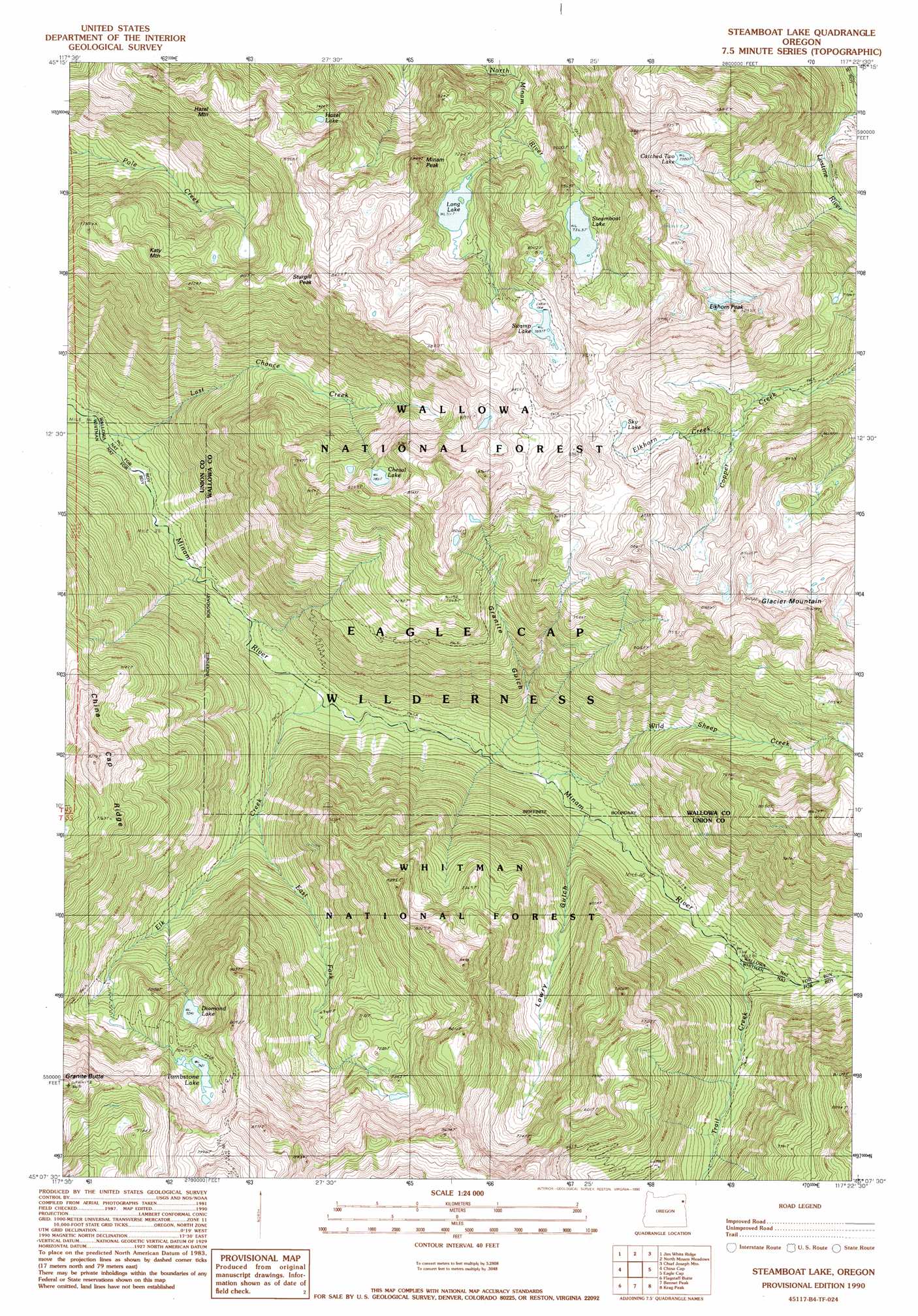
USGS Topo Quad 45117b4 - 1:24,000 scale
| Topo Map Name: | Steamboat Lake |
| USGS Topo Quad ID: | 45117b4 |
| Print Size: | ca. 21 1/4" wide x 27" high |
| Southeast Coordinates: | 45.125° N latitude / 117.375° W longitude |
| Map Center Coordinates: | 45.1875° N latitude / 117.4375° W longitude |
| U.S. State: | OR |
| Filename: | o45117b4.jpg |
| Download Map JPG Image: | Steamboat Lake topo map 1:24,000 scale |
| Map Type: | Topographic |
| Topo Series: | 7.5´ |
| Map Scale: | 1:24,000 |
| Source of Map Images: | United States Geological Survey (USGS) |
| Alternate Map Versions: |
Steamboat Lake OR 1990, updated 1990 Download PDF Buy paper map Steamboat Lake OR 2011 Download PDF Buy paper map Steamboat Lake OR 2014 Download PDF Buy paper map |
| FStopo: | US Forest Service topo Steamboat Lake is available: Download FStopo PDF Download FStopo TIF |
1:24,000 Topo Quads surrounding Steamboat Lake
Mount Moriah |
Fox Point |
Lostine |
Enterprise |
Joseph Nw |
Mount Fanny |
Jim White Ridge |
North Minam Meadows |
Chief Joseph Mountain |
Joseph |
Little Catherine Creek |
China Cap |
Steamboat Lake |
Eagle Cap |
Aneroid Mountain |
Medical Springs |
Flagstaff Butte |
Bennet Peak |
Krag Peak |
Cornucopia |
Keating Nw |
Sawtooth Ridge |
Balm Creek Reservoir |
Sparta Butte |
Jimtown |
> Back to 45117a1 at 1:100,000 scale
> Back to 45116a1 at 1:250,000 scale
> Back to U.S. Topo Maps home
Steamboat Lake topo map: Gazetteer
Steamboat Lake: Lakes
Catched Two Lake elevation 2437m 7995′Cheval Lake elevation 2387m 7831′
Diamond Lake elevation 2148m 7047′
Hazel Lake elevation 2264m 7427′
Long Lake elevation 2171m 7122′
Sky Lake elevation 2524m 8280′
Steamboat Lake elevation 2247m 7372′
Swamp Lake elevation 2411m 7910′
Tombstone Lake elevation 2263m 7424′
Steamboat Lake: Ridges
China Cap Ridge elevation 2485m 8152′Steamboat Lake: Streams
East Fork Elk Creek elevation 1639m 5377′Elk Creek elevation 1483m 4865′
Elkhorn Creek elevation 2242m 7355′
Last Chance Creek elevation 1426m 4678′
Trail Creek elevation 1632m 5354′
Wild Sheep Creek elevation 1539m 5049′
Steamboat Lake: Summits
Elkhorn Peak elevation 2732m 8963′Glacier Mountain elevation 2740m 8989′
Hazel Mountain elevation 2544m 8346′
Katy Mountain elevation 2410m 7906′
Minam Peak elevation 2404m 7887′
Sturgill Peak elevation 2620m 8595′
Steamboat Lake: Trails
Copper Creek Trail elevation 2153m 7063′Steamboat Lake: Valleys
Granite Gulch elevation 1532m 5026′Lowry Gulch elevation 1557m 5108′
Steamboat Lake digital topo map on disk
Buy this Steamboat Lake topo map showing relief, roads, GPS coordinates and other geographical features, as a high-resolution digital map file on DVD: