Starvation Ridge Topo Map Oregon
To zoom in, hover over the map of Starvation Ridge
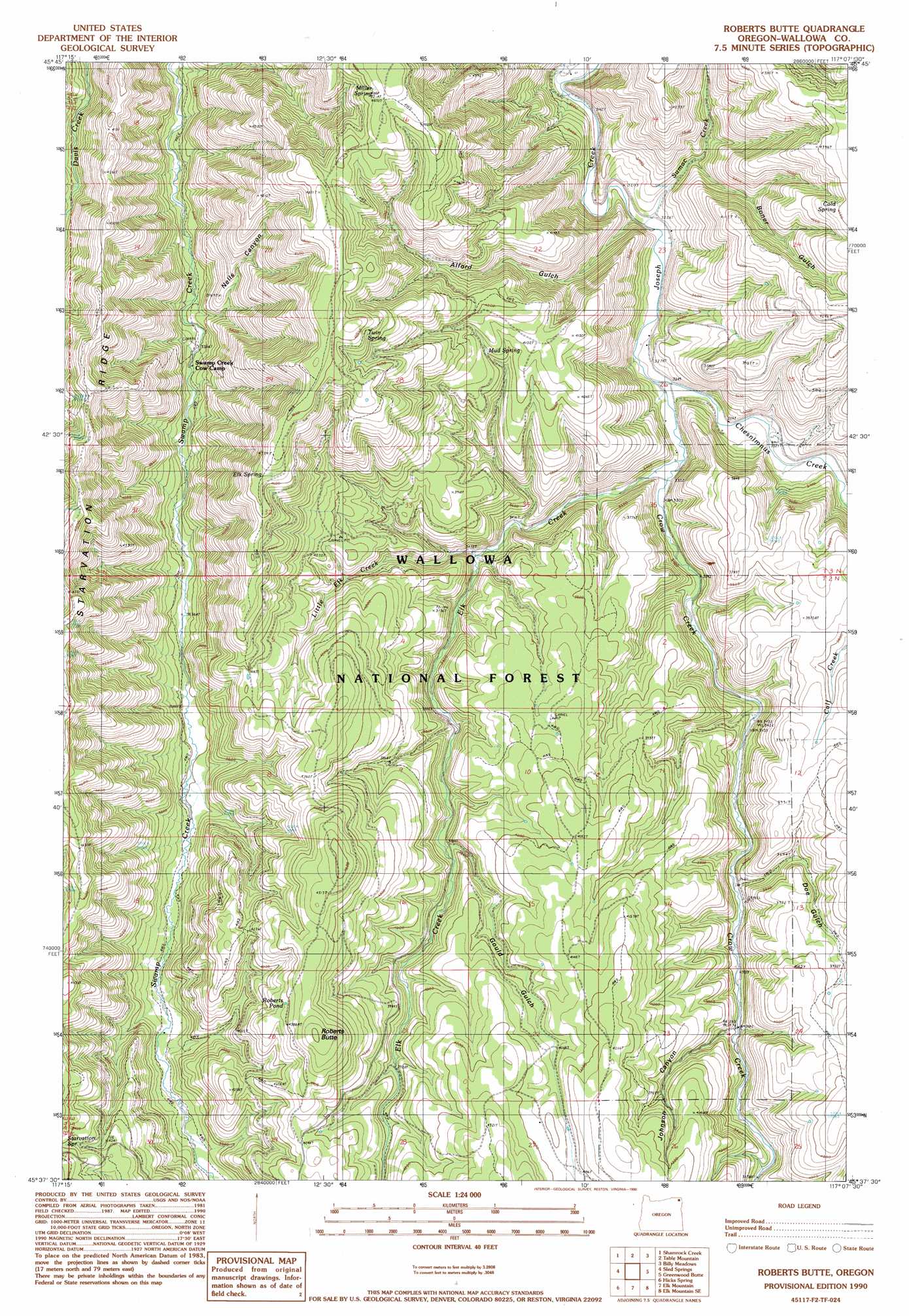
USGS Topo Quad 45117f2 - 1:24,000 scale
| Topo Map Name: | Starvation Ridge |
| USGS Topo Quad ID: | 45117f2 |
| Print Size: | ca. 21 1/4" wide x 27" high |
| Southeast Coordinates: | 45.625° N latitude / 117.125° W longitude |
| Map Center Coordinates: | 45.6875° N latitude / 117.1875° W longitude |
| U.S. State: | OR |
| Filename: | o45117f2.jpg |
| Download Map JPG Image: | Starvation Ridge topo map 1:24,000 scale |
| Map Type: | Topographic |
| Topo Series: | 7.5´ |
| Map Scale: | 1:24,000 |
| Source of Map Images: | United States Geological Survey (USGS) |
| Alternate Map Versions: |
Roberts Butte OR 1990, updated 1990 Download PDF Buy paper map Roberts Butte OR 2011 Download PDF Buy paper map Roberts Butte OR 2014 Download PDF Buy paper map |
| FStopo: | US Forest Service topo Roberts Butte is available: Download FStopo PDF Download FStopo TIF |
1:24,000 Topo Quads surrounding Starvation Ridge
Troy |
Flora |
Paradise |
Teepee Butte |
Jim Creek Butte |
Wood Butte |
Shamrock Creek |
Table Mountain |
Billy Meadows |
Poison Point |
Washboard Ridge |
Sled Springs |
Starvation Ridge |
Greenwood Butte |
Zumwalt |
Evans |
Hicks Spring |
Elk Mountain |
Elk Mountain Se |
Findley Buttes |
Lostine |
Enterprise |
Joseph Nw |
Three Lakes Country |
Clear Lake Ridge |
> Back to 45117e1 at 1:100,000 scale
> Back to 45116a1 at 1:250,000 scale
> Back to U.S. Topo Maps home
Starvation Ridge topo map: Gazetteer
Starvation Ridge: Populated Places
Chico (historical) elevation 986m 3234′Starvation Ridge: Post Offices
Chico Post Office (historical) elevation 986m 3234′Starvation Ridge: Reservoirs
Roberts Pond elevation 1335m 4379′Starvation Ridge: Ridges
Starvation Ridge elevation 1428m 4685′Starvation Ridge: Springs
Cement Spring (historical) elevation 1284m 4212′Cold Spring elevation 1312m 4304′
Double Spring (historical) elevation 1468m 4816′
Elk Spring elevation 1424m 4671′
Miller Spring elevation 1467m 4812′
Mud Spring elevation 1234m 4048′
Twin Spring elevation 1439m 4721′
Starvation Ridge: Streams
Chesnimnus Creek elevation 988m 3241′Crow Creek elevation 988m 3241′
Elk Creek elevation 1002m 3287′
Little Elk Creek elevation 1061m 3480′
Sumac Creek elevation 978m 3208′
Starvation Ridge: Summits
Roberts Butte elevation 1405m 4609′Starvation Ridge: Trails
Chico Trail elevation 1479m 4852′Starvation Ridge: Valleys
Alford Gulch elevation 1019m 3343′Boner Gulch elevation 1025m 3362′
Doe Gulch elevation 1075m 3526′
Gould Gulch elevation 1129m 3704′
Johnson Canyon elevation 1107m 3631′
Nells Canyon elevation 1032m 3385′
Starvation Ridge digital topo map on disk
Buy this Starvation Ridge topo map showing relief, roads, GPS coordinates and other geographical features, as a high-resolution digital map file on DVD: