Billy Meadows Topo Map Oregon
To zoom in, hover over the map of Billy Meadows
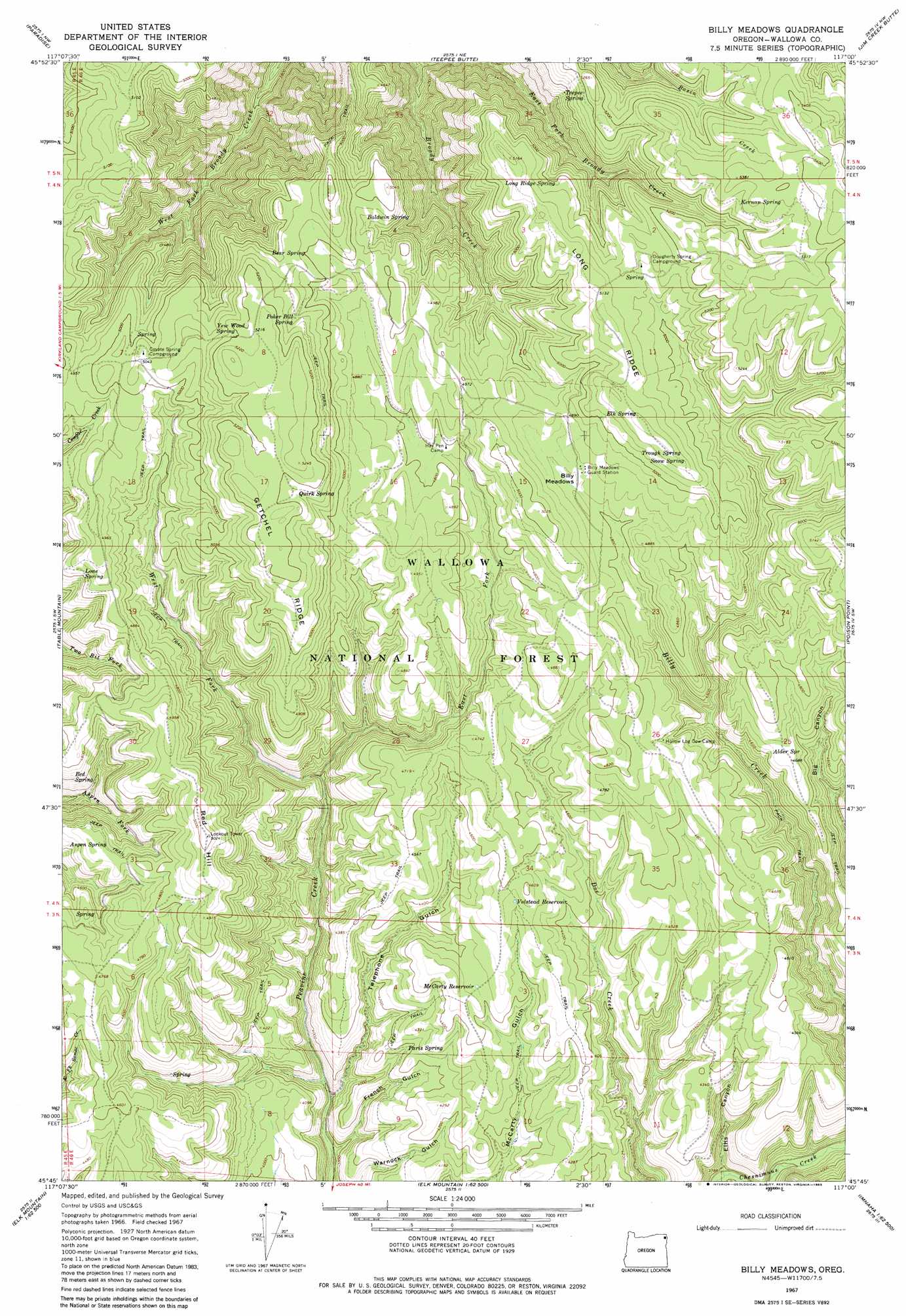
USGS Topo Quad 45117g1 - 1:24,000 scale
| Topo Map Name: | Billy Meadows |
| USGS Topo Quad ID: | 45117g1 |
| Print Size: | ca. 21 1/4" wide x 27" high |
| Southeast Coordinates: | 45.75° N latitude / 117° W longitude |
| Map Center Coordinates: | 45.8125° N latitude / 117.0625° W longitude |
| U.S. State: | OR |
| Filename: | o45117g1.jpg |
| Download Map JPG Image: | Billy Meadows topo map 1:24,000 scale |
| Map Type: | Topographic |
| Topo Series: | 7.5´ |
| Map Scale: | 1:24,000 |
| Source of Map Images: | United States Geological Survey (USGS) |
| Alternate Map Versions: |
Billy Meadows OR 1967, updated 1971 Download PDF Buy paper map Billy Meadows OR 1967, updated 1983 Download PDF Buy paper map Billy Meadows OR 2011 Download PDF Buy paper map Billy Meadows OR 2014 Download PDF Buy paper map |
| FStopo: | US Forest Service topo Billy Meadows is available: Download FStopo PDF Download FStopo TIF |
1:24,000 Topo Quads surrounding Billy Meadows
Mountain View |
Fields Spring |
Black Butte |
Limekiln Rapids |
Frye Point |
Flora |
Paradise |
Teepee Butte |
Jim Creek Butte |
Wapshilla Creek |
Shamrock Creek |
Table Mountain |
Billy Meadows |
Poison Point |
Deadhorse Ridge |
Sled Springs |
Starvation Ridge |
Greenwood Butte |
Zumwalt |
Haas Hollow |
Hicks Spring |
Elk Mountain |
Elk Mountain Se |
Findley Buttes |
Imnaha |
> Back to 45117e1 at 1:100,000 scale
> Back to 45116a1 at 1:250,000 scale
> Back to U.S. Topo Maps home
Billy Meadows topo map: Gazetteer
Billy Meadows: Flats
Billy Meadows elevation 1478m 4849′Getchel Meadows elevation 1584m 5196′
Billy Meadows: Reservoirs
McCarty Reservoir elevation 1350m 4429′Volstead Reservoir elevation 1388m 4553′
Billy Meadows: Ridges
Getchel Ridge elevation 1593m 5226′Long Ridge elevation 1571m 5154′
Billy Meadows: Springs
Alder Spring elevation 1424m 4671′Aspen Spring elevation 1416m 4645′
Baldwin Spring elevation 1498m 4914′
Bear Spring elevation 1524m 5000′
Bed Spring elevation 1417m 4648′
Coyote Spring elevation 1522m 4993′
Dougherty Spring elevation 1556m 5104′
Elk Spring elevation 1545m 5068′
Hinton Spring elevation 1373m 4504′
Hollow Log Spring elevation 1379m 4524′
Kernan Spring elevation 1610m 5282′
Lone Spring elevation 1456m 4776′
Long Ridge Spring elevation 1544m 5065′
Paris Spring elevation 1277m 4189′
Poker Bill Spring elevation 1548m 5078′
Quirk Spring elevation 1574m 5164′
Snow Spring elevation 1540m 5052′
Teepee Spring elevation 1494m 4901′
Trough Spring elevation 1544m 5065′
Warnock Spring elevation 1269m 4163′
Yew Wood Spring elevation 1548m 5078′
Billy Meadows: Streams
East Fork Broady Creek elevation 1142m 3746′East Fork Peavine Creek elevation 1278m 4192′
West Fork Peavine Creek elevation 1278m 4192′
Billy Meadows: Summits
Red Hill elevation 1524m 5000′Billy Meadows: Valleys
Ellis Canyon elevation 1159m 3802′French Gulch elevation 1141m 3743′
Telephone Gulch elevation 1158m 3799′
Billy Meadows digital topo map on disk
Buy this Billy Meadows topo map showing relief, roads, GPS coordinates and other geographical features, as a high-resolution digital map file on DVD: