Elbow Creek Topo Map Oregon
To zoom in, hover over the map of Elbow Creek
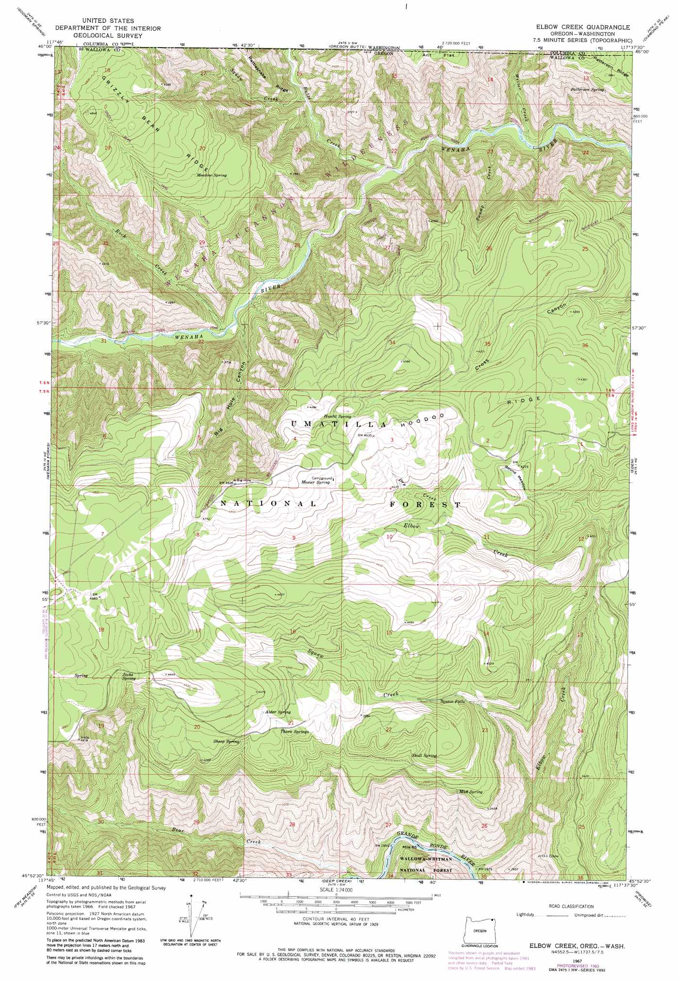
USGS Topo Quad 45117h6 - 1:24,000 scale
| Topo Map Name: | Elbow Creek |
| USGS Topo Quad ID: | 45117h6 |
| Print Size: | ca. 21 1/4" wide x 27" high |
| Southeast Coordinates: | 45.875° N latitude / 117.625° W longitude |
| Map Center Coordinates: | 45.9375° N latitude / 117.6875° W longitude |
| U.S. States: | OR, WA |
| Filename: | o45117h6.jpg |
| Download Map JPG Image: | Elbow Creek topo map 1:24,000 scale |
| Map Type: | Topographic |
| Topo Series: | 7.5´ |
| Map Scale: | 1:24,000 |
| Source of Map Images: | United States Geological Survey (USGS) |
| Alternate Map Versions: |
Elbow Creek OR 1967, updated 1971 Download PDF Buy paper map Elbow Creek OR 1967, updated 1983 Download PDF Buy paper map Elbow Creek OR 1967, updated 1983 Download PDF Buy paper map Elbow Creek OR 1995, updated 1998 Download PDF Buy paper map Elbow Creek OR 2011 Download PDF Buy paper map Elbow Creek OR 2014 Download PDF Buy paper map |
| FStopo: | US Forest Service topo Elbow Creek is available: Download FStopo PDF Download FStopo TIF |
1:24,000 Topo Quads surrounding Elbow Creek
Robinette Mountain |
Eckler Mountain |
Panjab Creek |
Stentz Spring |
Pinkham Butte |
Deadman Peak |
Godman Spring |
Oregon Butte |
Diamond Peak |
Saddle Butte |
Bone Spring |
Wenaha Forks |
Elbow Creek |
Eden |
Troy |
Jubilee Lake |
Fry Meadow |
Deep Creek |
Promise |
Wood Butte |
Partridge Creek |
Rondowa |
Howard Butte |
Akers Butte |
Washboard Ridge |
> Back to 45117e1 at 1:100,000 scale
> Back to 45116a1 at 1:250,000 scale
> Back to U.S. Topo Maps home
Elbow Creek topo map: Gazetteer
Elbow Creek: Falls
Squaw Falls elevation 1111m 3645′Elbow Creek: Flats
Ant Flat elevation 1281m 4202′Round Meadow elevation 1275m 4183′
Elbow Creek: Ridges
Grizzly Bear Ridge elevation 1429m 4688′Hoodoo Ridge elevation 1325m 4347′
Elbow Creek: Springs
Alder Spring elevation 1310m 4297′Huntit Spring elevation 1376m 4514′
Jacks Spring elevation 1441m 4727′
Meadow Spring elevation 1317m 4320′
Mosier Spring elevation 1422m 4665′
Mud Spring elevation 1052m 3451′
Patterson Spring elevation 1104m 3622′
Rock Spring elevation 1221m 4005′
Sheep Spring elevation 1284m 4212′
Skull Spring elevation 1147m 3763′
Thorn Springs elevation 1241m 4071′
Elbow Creek: Streams
Bear Creek elevation 611m 2004′Butte Creek elevation 711m 2332′
Dry Creek elevation 1220m 4002′
Elbow Creek elevation 599m 1965′
Rock Creek elevation 795m 2608′
Rock Creek elevation 767m 2516′
Squaw Creek elevation 702m 2303′
Squaw Creek elevation 784m 2572′
Weller Creek elevation 674m 2211′
Elbow Creek: Trails
Cross Canyon Trail elevation 1396m 4580′Elbow Creek: Valleys
Big Hole Canyon elevation 763m 2503′Elbow Creek digital topo map on disk
Buy this Elbow Creek topo map showing relief, roads, GPS coordinates and other geographical features, as a high-resolution digital map file on DVD: