Hilgard Topo Map Oregon
To zoom in, hover over the map of Hilgard
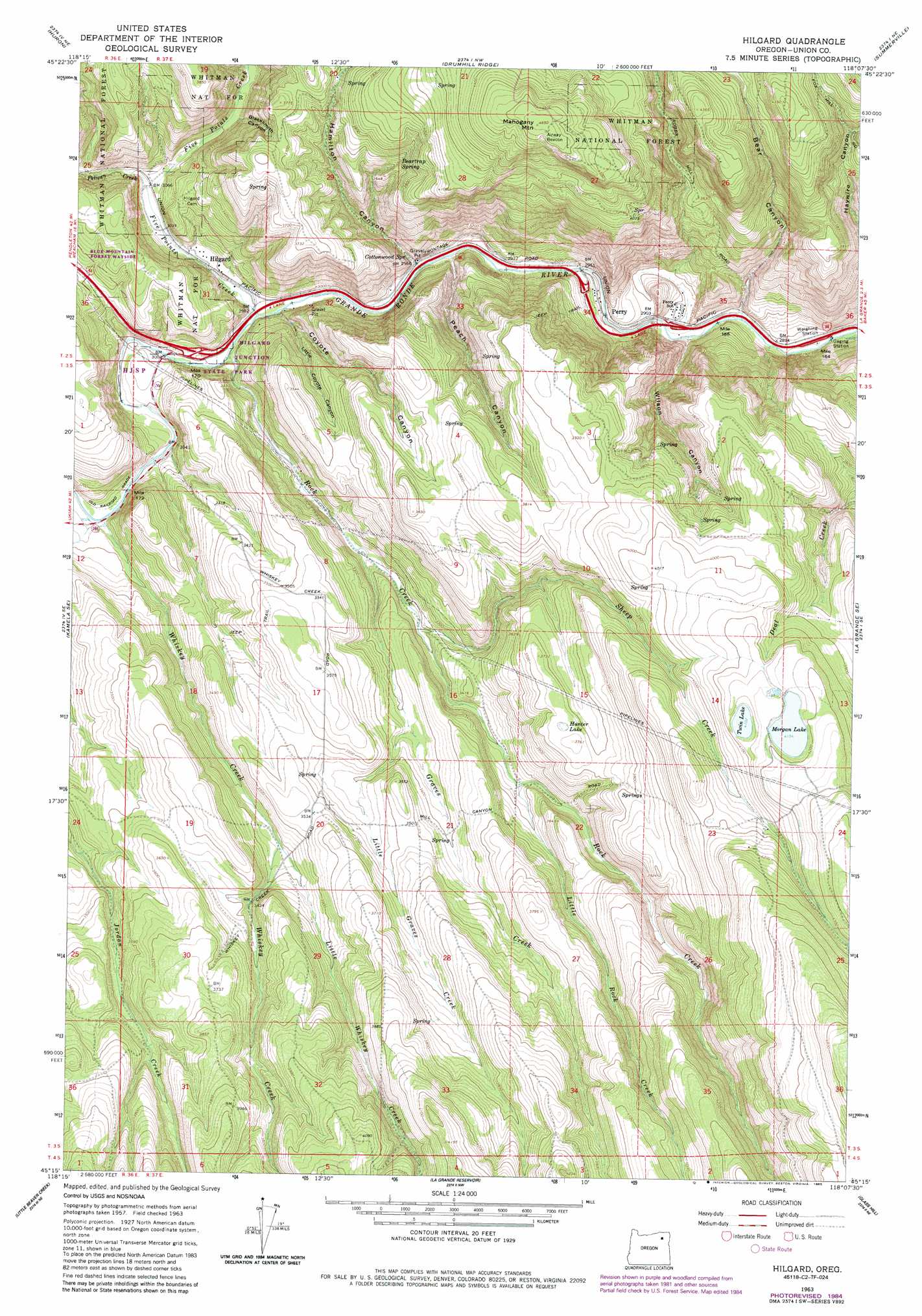
USGS Topo Quad 45118c2 - 1:24,000 scale
| Topo Map Name: | Hilgard |
| USGS Topo Quad ID: | 45118c2 |
| Print Size: | ca. 21 1/4" wide x 27" high |
| Southeast Coordinates: | 45.25° N latitude / 118.125° W longitude |
| Map Center Coordinates: | 45.3125° N latitude / 118.1875° W longitude |
| U.S. State: | OR |
| Filename: | o45118c2.jpg |
| Download Map JPG Image: | Hilgard topo map 1:24,000 scale |
| Map Type: | Topographic |
| Topo Series: | 7.5´ |
| Map Scale: | 1:24,000 |
| Source of Map Images: | United States Geological Survey (USGS) |
| Alternate Map Versions: |
Hilgard OR 1963, updated 1966 Download PDF Buy paper map Hilgard OR 1963, updated 1983 Download PDF Buy paper map Hilgard OR 1963, updated 1985 Download PDF Buy paper map Hilgard OR 2011 Download PDF Buy paper map Hilgard OR 2014 Download PDF Buy paper map |
| FStopo: | US Forest Service topo Hilgard is available: Download FStopo PDF Download FStopo TIF |
1:24,000 Topo Quads surrounding Hilgard
Meacham |
Duncan |
Thimbleberry Mountain |
Sanderson Spring |
Elgin |
Meacham Lake |
Huron |
Drumhill Ridge |
Summerville |
Imbler |
Mcintyre Creek |
Kamela Se |
Hilgard |
La Grande |
Conley |
Marley Creek |
Little Beaver Creek |
La Grande Reservoir |
Glass Hill |
Craig Mountain |
Fly Valley |
Limber Jim Creek |
Anthony Butte |
Tucker Flat |
North Powder |
> Back to 45118a1 at 1:100,000 scale
> Back to 45118a1 at 1:250,000 scale
> Back to U.S. Topo Maps home
Hilgard topo map: Gazetteer
Hilgard: Dams
Morgan Lake Dam elevation 1267m 4156′Hilgard: Lakes
Hunter Lake elevation 1135m 3723′Morgan Lake elevation 1267m 4156′
Twin Lake elevation 1251m 4104′
Hilgard: Parks
Hilgard Junction State Park elevation 925m 3034′Morgan Lake Park elevation 1267m 4156′
Hilgard: Populated Places
Hilgard elevation 915m 3001′Perry elevation 883m 2896′
Hilgard: Post Offices
Hilgard Post Office (historical) elevation 915m 3001′Perry Post Office (historical) elevation 883m 2896′
Hilgard: Springs
Beartrap Spring elevation 1133m 3717′Cottonwood Spring elevation 905m 2969′
Mouse Spring elevation 1133m 3717′
Hilgard: Streams
Five Points Creek elevation 907m 2975′Graves Creek elevation 952m 3123′
Little Graves Creek elevation 1012m 3320′
Little Rock Creek elevation 1021m 3349′
Little Whiskey Creek elevation 1023m 3356′
Pelican Creek elevation 928m 3044′
Robbs Creek elevation 879m 2883′
Rock Creek elevation 910m 2985′
Sheep Creek elevation 974m 3195′
Whiskey Creek elevation 923m 3028′
Hilgard: Summits
Mahogany Mountain elevation 1417m 4648′Hilgard: Valleys
Bear Canyon elevation 873m 2864′Blacksmith Canyon elevation 949m 3113′
Coyote Canyon elevation 906m 2972′
Hamilton Canyon elevation 909m 2982′
Little Coyote Canyon elevation 928m 3044′
Peach Canyon elevation 899m 2949′
Wilson Canyon elevation 879m 2883′
Hilgard digital topo map on disk
Buy this Hilgard topo map showing relief, roads, GPS coordinates and other geographical features, as a high-resolution digital map file on DVD: