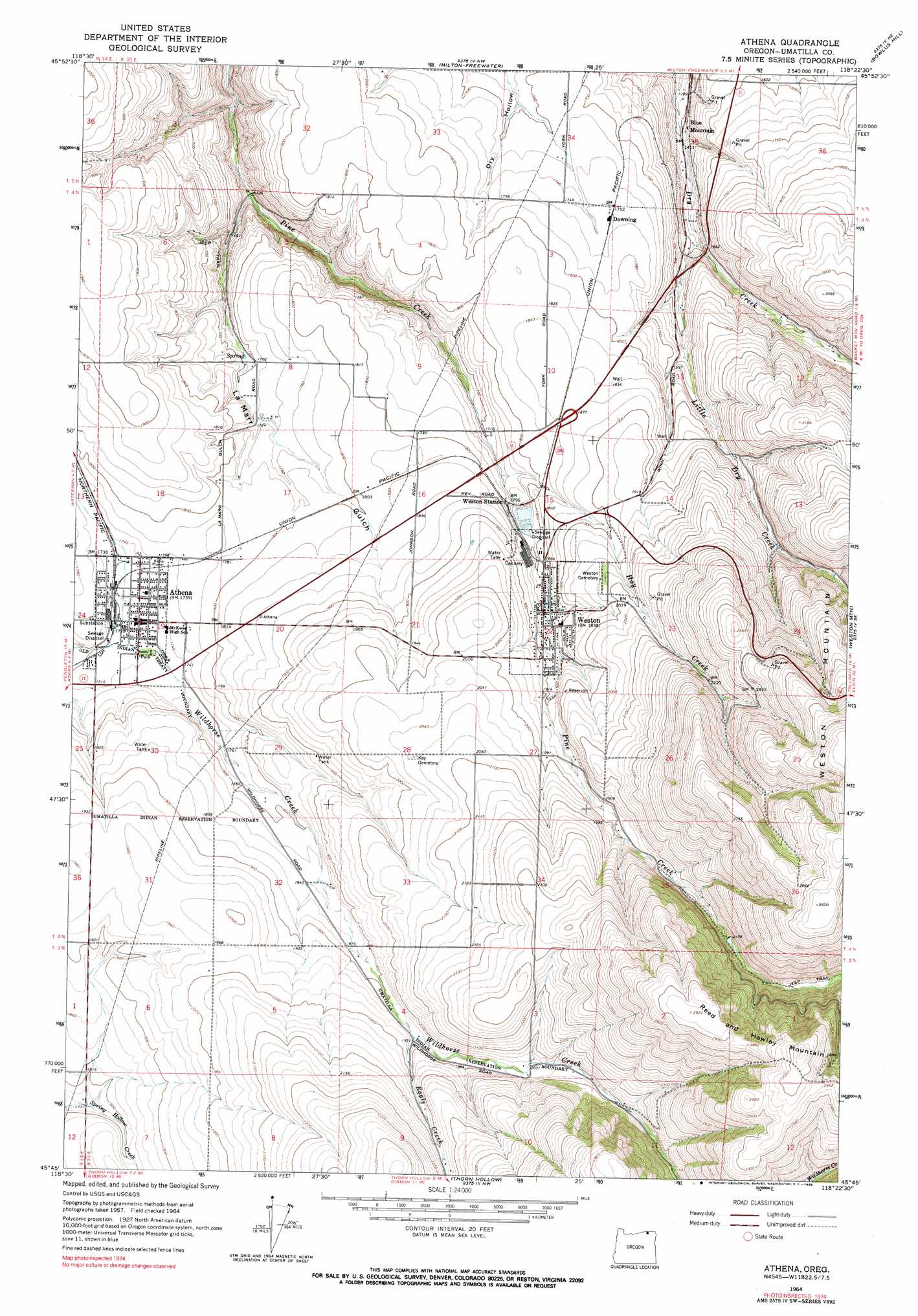
Athena Topo Map Oregon
To zoom in, hover over the map of Athena
USGS Topo Quad 45118g4 - 1:24,000 scale
| Topo Map Name: | Athena |
| USGS Topo Quad ID: | 45118g4 |
| Print Size: | ca. 21 1/4" wide x 27" high |
| Southeast Coordinates: | 45.75° N latitude / 118.375° W longitude |
| Map Center Coordinates: | 45.8125° N latitude / 118.4375° W longitude |
| U.S. State: | OR |
| Filename: | o45118g4.jpg |
| Download Map JPG Image: | Athena topo map 1:24,000 scale |
| Map Type: | Topographic |
| Topo Series: | 7.5´ |
| Map Scale: | 1:24,000 |
| Source of Map Images: | United States Geological Survey (USGS) |
| Alternate Map Versions: |
Athena OR 1964, updated 1965 Download PDF Buy paper map Athena OR 1964, updated 1990 Download PDF Buy paper map Athena OR 2011 Download PDF Buy paper map Athena OR 2014 Download PDF Buy paper map |
1:24,000 Topo Quads surrounding Athena
Touchet |
Lowden |
College Place |
Walla Walla |
Buroker |
Smeltz |
Waterman |
Milton-Freewater |
Bowlus Hill |
Peterson Ridge |
Helix |
Adams |
Athena |
Weston Mountain |
Blalock Mountain |
Mission |
Cayuse |
Thorn Hollow |
Gibbon |
Bingham Springs |
Table Rock |
Cabbage Hill |
Meacham |
Duncan |
Thimbleberry Mountain |
> Back to 45118e1 at 1:100,000 scale
> Back to 45118a1 at 1:250,000 scale
> Back to U.S. Topo Maps home
Athena topo map: Gazetteer
Athena: Dams
Poplar Springs Dam elevation 709m 2326′Athena: Parks
Athena City Park elevation 523m 1715′Athena Memorial Ball Park elevation 531m 1742′
Duggor Park elevation 528m 1732′
Elliott Memorial Park elevation 564m 1850′
Athena: Populated Places
Athena elevation 526m 1725′Weston elevation 562m 1843′
Athena: Post Offices
Athena Post Office elevation 526m 1725′Weston Post Office elevation 562m 1843′
Athena: Reservoirs
Pine Springs Reservoir elevation 648m 2125′Poplar Springs Reservoir elevation 709m 2326′
Athena: Springs
Earthquake Spring elevation 516m 1692′Green Spring elevation 655m 2148′
Athena: Streams
Eagle Creek elevation 593m 1945′Hay Creek elevation 531m 1742′
Little Dry Creek elevation 451m 1479′
Athena: Valleys
La Marr Gulch elevation 438m 1437′Athena digital topo map on disk
Buy this Athena topo map showing relief, roads, GPS coordinates and other geographical features, as a high-resolution digital map file on DVD: