Deerhorn Creek Topo Map Oregon
To zoom in, hover over the map of Deerhorn Creek
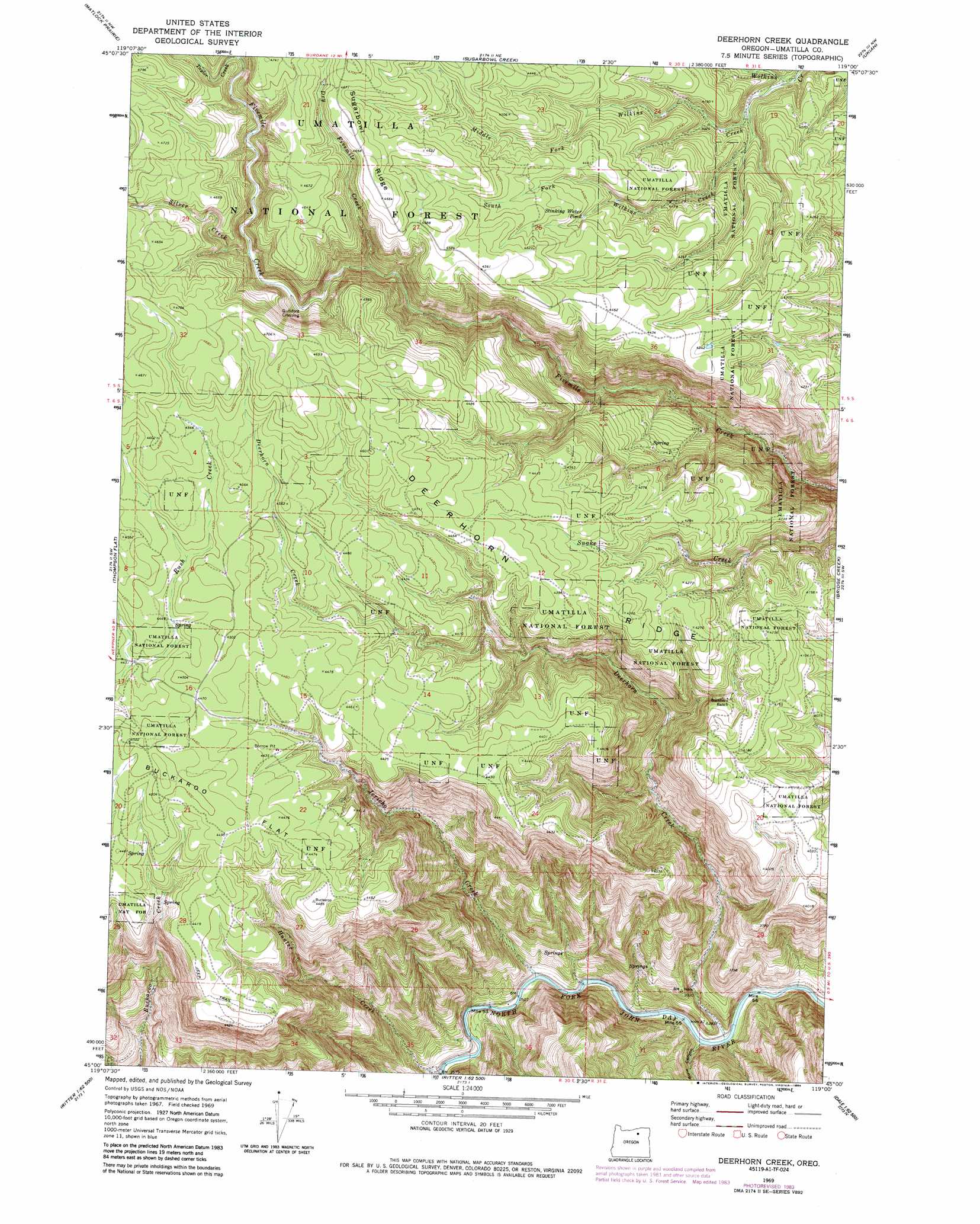
USGS Topo Quad 45119a1 - 1:24,000 scale
| Topo Map Name: | Deerhorn Creek |
| USGS Topo Quad ID: | 45119a1 |
| Print Size: | ca. 21 1/4" wide x 27" high |
| Southeast Coordinates: | 45° N latitude / 119° W longitude |
| Map Center Coordinates: | 45.0625° N latitude / 119.0625° W longitude |
| U.S. State: | OR |
| Filename: | o45119a1.jpg |
| Download Map JPG Image: | Deerhorn Creek topo map 1:24,000 scale |
| Map Type: | Topographic |
| Topo Series: | 7.5´ |
| Map Scale: | 1:24,000 |
| Source of Map Images: | United States Geological Survey (USGS) |
| Alternate Map Versions: |
Deerhorn Creek OR 1969, updated 1973 Download PDF Buy paper map Deerhorn Creek OR 1969, updated 1984 Download PDF Buy paper map Deerhorn Creek OR 1995, updated 1998 Download PDF Buy paper map Deerhorn Creek OR 2011 Download PDF Buy paper map Deerhorn Creek OR 2014 Download PDF Buy paper map |
| FStopo: | US Forest Service topo Deerhorn Creek is available: Download FStopo PDF Download FStopo TIF |
1:24,000 Topo Quads surrounding Deerhorn Creek
Freezeout Ridge |
Hoodlum Canyon |
Gurdane |
Carney Butte |
Granite Meadows |
Arbuckle Mountain |
Matlock Prairie |
Sugarbowl Creek |
Ukiah |
Owens Butte |
Lake Penland |
Thompson Flat |
Deerhorn Creek |
Bridge Creek |
Ukiah Se |
Slickear Mountain |
Ritter |
Meadow Brook Summit |
Dale |
The Cockscomb |
Steet Mountain |
Bullock Gulch |
Flowers Gulch |
Wildcat Point |
Sharp Ridge |
> Back to 45119a1 at 1:100,000 scale
> Back to 45118a1 at 1:250,000 scale
> Back to U.S. Topo Maps home
Deerhorn Creek topo map: Gazetteer
Deerhorn Creek: Flats
Buckaroo Flat elevation 1369m 4491′Deerhorn Creek: Lakes
Stinking Water Pond elevation 1332m 4370′Deerhorn Creek: Ridges
Deerhorn Ridge elevation 1347m 4419′Deerhorn Creek: Springs
Box Spring elevation 1311m 4301′Deerhorn Creek: Streams
Deerhorn Creek elevation 811m 2660′Dry Fivemile Creek elevation 1243m 4078′
Hunter Creek elevation 788m 2585′
Jericho Creek elevation 797m 2614′
Middle Fork Wilkins Creek elevation 1194m 3917′
Silver Creek elevation 1296m 4251′
South Fork Wilkins Creek elevation 1172m 3845′
Taylor Creek elevation 1371m 4498′
Deerhorn Creek: Valleys
Bone Canyon elevation 812m 2664′Deerhorn Creek digital topo map on disk
Buy this Deerhorn Creek topo map showing relief, roads, GPS coordinates and other geographical features, as a high-resolution digital map file on DVD: