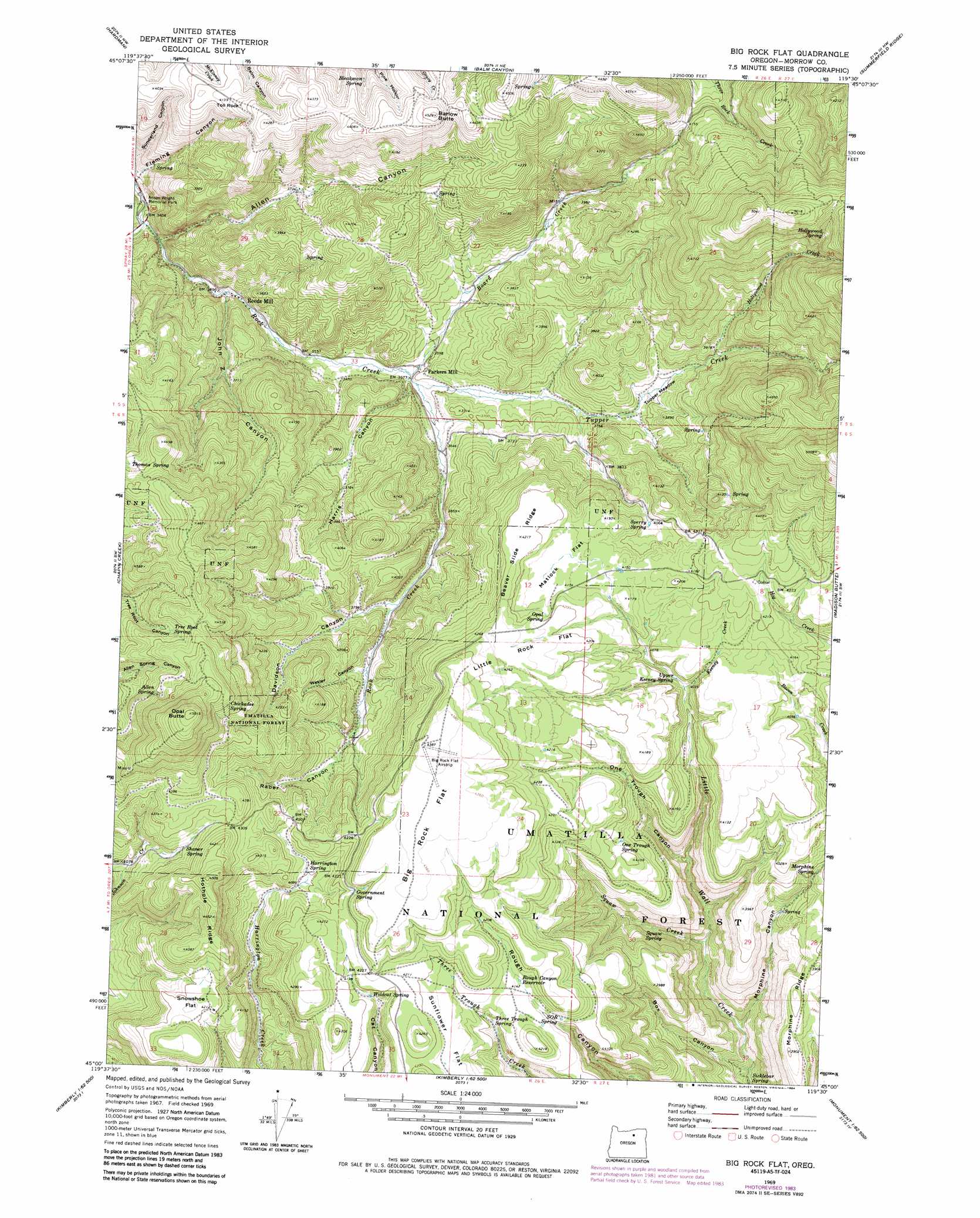
Big Rock Flat Topo Map Oregon
To zoom in, hover over the map of Big Rock Flat
USGS Topo Quad 45119a5 - 1:24,000 scale
| Topo Map Name: | Big Rock Flat |
| USGS Topo Quad ID: | 45119a5 |
| Print Size: | ca. 21 1/4" wide x 27" high |
| Southeast Coordinates: | 45° N latitude / 119.5° W longitude |
| Map Center Coordinates: | 45.0625° N latitude / 119.5625° W longitude |
| U.S. State: | OR |
| Filename: | o45119a5.jpg |
| Download Map JPG Image: | Big Rock Flat topo map 1:24,000 scale |
| Map Type: | Topographic |
| Topo Series: | 7.5´ |
| Map Scale: | 1:24,000 |
| Source of Map Images: | United States Geological Survey (USGS) |
| Alternate Map Versions: |
Big Rock Flat OR 1969, updated 1973 Download PDF Buy paper map Big Rock Flat OR 1969, updated 1984 Download PDF Buy paper map Big Rock Flat OR 1995, updated 1998 Download PDF Buy paper map Big Rock Flat OR 2011 Download PDF Buy paper map Big Rock Flat OR 2014 Download PDF Buy paper map |
| FStopo: | US Forest Service topo Big Rock Flat is available: Download FStopo PDF Download FStopo TIF |
1:24,000 Topo Quads surrounding Big Rock Flat
Eightmile |
Ruggs |
Heppner |
Skinners Fork |
Freezeout Ridge |
Buttermilk Canyon |
Hardman |
Balm Canyon |
Summerfield Ridge |
Arbuckle Mountain |
Lefevre Prairie |
Chapin Creek |
Big Rock Flat |
Madison Butte |
Lake Penland |
Collins Butte |
Whitetail Butte |
Turner Mountain |
Johnny Cake Mountain |
Slickear Mountain |
Spray |
Kimberly |
Bologna Basin |
Monument |
Steet Mountain |
> Back to 45119a1 at 1:100,000 scale
> Back to 45118a1 at 1:250,000 scale
> Back to U.S. Topo Maps home
Big Rock Flat topo map: Gazetteer
Big Rock Flat: Airports
Big Flat Airstrip elevation 1339m 4393′Big Rock Flat: Flats
Big Rock Flat elevation 1332m 4370′Little Rock Flat elevation 1288m 4225′
Matlock Flat elevation 1266m 4153′
Snowshoe Flat elevation 1285m 4215′
Sunflower Flat elevation 1273m 4176′
Tupper Meadow elevation 1154m 3786′
Big Rock Flat: Parks
Anson Wright Memorial Park elevation 1033m 3389′Big Rock Flat: Pillars
Toll Rock elevation 1275m 4183′Big Rock Flat: Post Offices
Parkers Mills Post Office (historical) elevation 1090m 3576′Big Rock Flat: Reservoirs
Rough Canyon Reservoir elevation 1261m 4137′Big Rock Flat: Ridges
Beaver Slide Ridge elevation 1286m 4219′Hothole Ridge elevation 1357m 4452′
Morphine Ridge elevation 1191m 3907′
Big Rock Flat: Springs
Allen Spring elevation 1377m 4517′Bleakman Spring elevation 1278m 4192′
Chickadee Spring elevation 1400m 4593′
Government Spring elevation 1297m 4255′
Harrington Spring elevation 1253m 4110′
Hollywood Spring elevation 1433m 4701′
Matlock Spring elevation 1289m 4229′
Matlock Spring elevation 1268m 4160′
Morphine Spring elevation 1176m 3858′
One Trough Spring elevation 1243m 4078′
Opal Spring elevation 1278m 4192′
Shaner Spring elevation 1284m 4212′
Sicklebar Spring elevation 1002m 3287′
SOB Spring elevation 1258m 4127′
Sperry Spring elevation 1237m 4058′
Squaw Spring elevation 1095m 3592′
Three Trough Spring elevation 1240m 4068′
Tree Root Spring elevation 1352m 4435′
Upper Keeney Spring elevation 1233m 4045′
Wildcat Spring elevation 1272m 4173′
Big Rock Flat: Streams
Board Creek elevation 1088m 3569′Chapin Creek elevation 1038m 3405′
Hollywood Creek elevation 1187m 3894′
Keeney Creek elevation 1227m 4025′
Squaw Creek elevation 1059m 3474′
Tupper Creek elevation 1090m 3576′
Big Rock Flat: Summits
Barlow Butte elevation 1380m 4527′Opal Butte elevation 1527m 5009′
Big Rock Flat: Valleys
Allen Canyon elevation 1045m 3428′Box Canyon elevation 1004m 3293′
Davidson Canyon elevation 1142m 3746′
Harris Canyon elevation 1089m 3572′
John Z Canyon elevation 1060m 3477′
Morphine Canyon elevation 1028m 3372′
One Trough Canyon elevation 1132m 3713′
Raber Canyon elevation 1182m 3877′
Wesler Canyon elevation 1164m 3818′
Big Rock Flat digital topo map on disk
Buy this Big Rock Flat topo map showing relief, roads, GPS coordinates and other geographical features, as a high-resolution digital map file on DVD: