Chapin Creek Topo Map Oregon
To zoom in, hover over the map of Chapin Creek
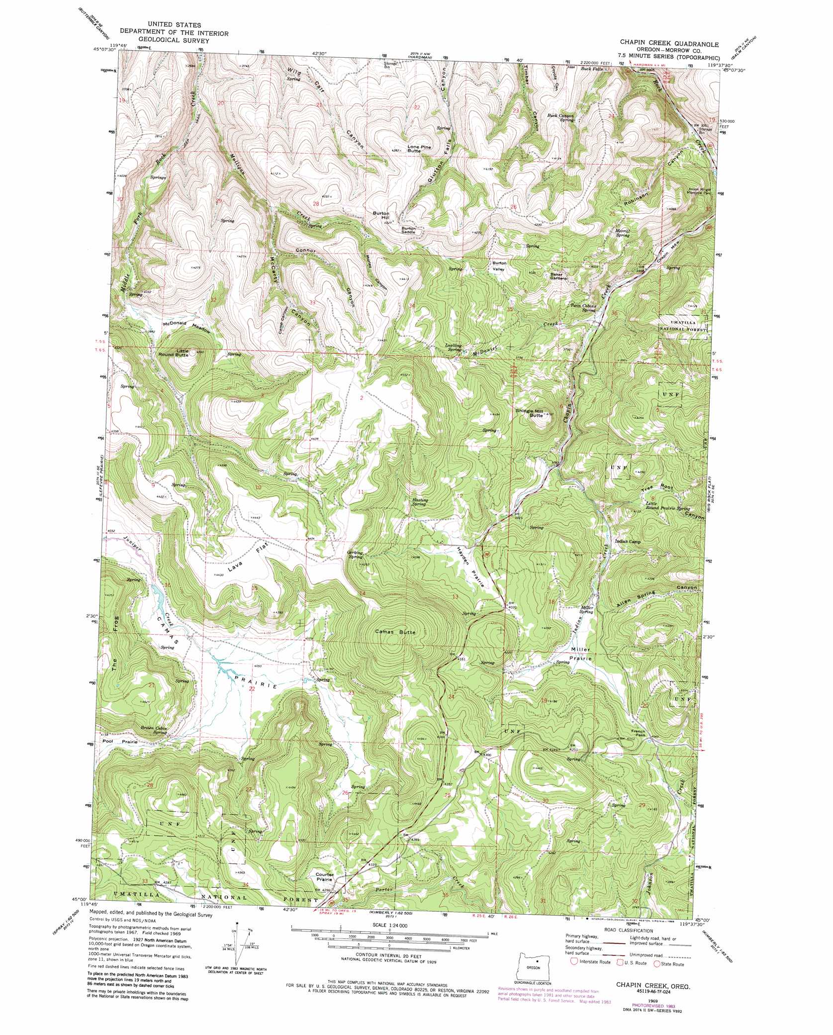
USGS Topo Quad 45119a6 - 1:24,000 scale
| Topo Map Name: | Chapin Creek |
| USGS Topo Quad ID: | 45119a6 |
| Print Size: | ca. 21 1/4" wide x 27" high |
| Southeast Coordinates: | 45° N latitude / 119.625° W longitude |
| Map Center Coordinates: | 45.0625° N latitude / 119.6875° W longitude |
| U.S. State: | OR |
| Filename: | o45119a6.jpg |
| Download Map JPG Image: | Chapin Creek topo map 1:24,000 scale |
| Map Type: | Topographic |
| Topo Series: | 7.5´ |
| Map Scale: | 1:24,000 |
| Source of Map Images: | United States Geological Survey (USGS) |
| Alternate Map Versions: |
Chapin Creek OR 1969, updated 1973 Download PDF Buy paper map Chapin Creek OR 1969, updated 1985 Download PDF Buy paper map Chapin Creek OR 1995, updated 1998 Download PDF Buy paper map Chapin Creek OR 2011 Download PDF Buy paper map Chapin Creek OR 2014 Download PDF Buy paper map |
| FStopo: | US Forest Service topo Chapin Creek is available: Download FStopo PDF Download FStopo TIF |
1:24,000 Topo Quads surrounding Chapin Creek
Gooseberry |
Eightmile |
Ruggs |
Heppner |
Skinners Fork |
Lone Rock Creek |
Buttermilk Canyon |
Hardman |
Balm Canyon |
Summerfield Ridge |
Lonerock |
Lefevre Prairie |
Chapin Creek |
Big Rock Flat |
Madison Butte |
Wheeler Point |
Collins Butte |
Whitetail Butte |
Turner Mountain |
Johnny Cake Mountain |
Massacre Mountain |
Spray |
Kimberly |
Bologna Basin |
Monument |
> Back to 45119a1 at 1:100,000 scale
> Back to 45118a1 at 1:250,000 scale
> Back to U.S. Topo Maps home
Chapin Creek topo map: Gazetteer
Chapin Creek: Areas
Baker Gardens elevation 1205m 3953′Chapin Creek: Falls
Buck Falls elevation 1069m 3507′Chapin Creek: Flats
Camas Prairie elevation 1235m 4051′Chapin Meadow elevation 1052m 3451′
Courter Prairie elevation 1314m 4311′
Hayden Prairie elevation 1206m 3956′
Lava Flat elevation 1351m 4432′
McDonald Meadow elevation 1188m 3897′
Miller Prairie elevation 1200m 3937′
Pool Prairie elevation 1261m 4137′
Chapin Creek: Gaps
Burton Saddle elevation 1310m 4297′French Pass elevation 1232m 4041′
Chapin Creek: Post Offices
Sinnott Post Office (historical) elevation 1244m 4081′Chapin Creek: Springs
Brown Cabin Spring elevation 1262m 4140′Buck Canyon Spring elevation 1143m 3750′
Gerking Spring elevation 1278m 4192′
Hasting Spring elevation 1253m 4110′
Little Round Prairie Spring elevation 1228m 4028′
Luelling Spring elevation 1208m 3963′
Merrill Spring elevation 1209m 3966′
Miller Spring elevation 1196m 3923′
Thomas Spring elevation 1328m 4356′
Twin Cabins Spring elevation 1077m 3533′
Chapin Creek: Streams
Colvin Creek elevation 1234m 4048′Indian Creek elevation 1142m 3746′
McDaniel Creek elevation 1075m 3526′
Mulligan Creek elevation 1010m 3313′
Chapin Creek: Summits
Burton Hill elevation 1320m 4330′Camas Butte elevation 1418m 4652′
Little Round Butte elevation 1320m 4330′
Lone Pine Butte elevation 1306m 4284′
Shingle Mill Butte elevation 1277m 4189′
Chapin Creek: Valleys
Allen Spring Canyon elevation 1185m 3887′Burton Valley elevation 1163m 3815′
Camp Canyon elevation 1236m 4055′
Connor Canyon elevation 1178m 3864′
Emery Canyon elevation 1020m 3346′
Fleming Canyon elevation 1039m 3408′
McCarty Canyon elevation 1135m 3723′
Morley Canyon elevation 1240m 4068′
Robinson Canyon elevation 1023m 3356′
Stevens Canyon elevation 1015m 3330′
Sunderland Canyon elevation 1045m 3428′
Tree Root Canyon elevation 1170m 3838′
Chapin Creek digital topo map on disk
Buy this Chapin Creek topo map showing relief, roads, GPS coordinates and other geographical features, as a high-resolution digital map file on DVD: