Lefevre Prairie Topo Map Oregon
To zoom in, hover over the map of Lefevre Prairie
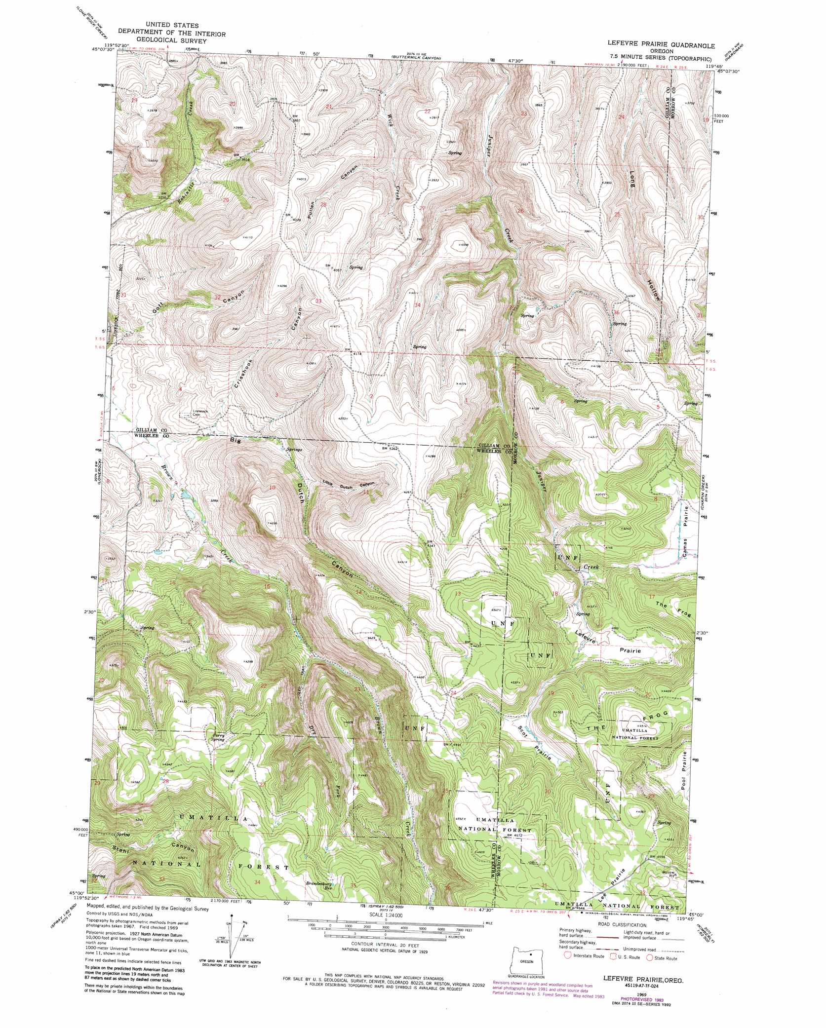
USGS Topo Quad 45119a7 - 1:24,000 scale
| Topo Map Name: | Lefevre Prairie |
| USGS Topo Quad ID: | 45119a7 |
| Print Size: | ca. 21 1/4" wide x 27" high |
| Southeast Coordinates: | 45° N latitude / 119.75° W longitude |
| Map Center Coordinates: | 45.0625° N latitude / 119.8125° W longitude |
| U.S. State: | OR |
| Filename: | o45119a7.jpg |
| Download Map JPG Image: | Lefevre Prairie topo map 1:24,000 scale |
| Map Type: | Topographic |
| Topo Series: | 7.5´ |
| Map Scale: | 1:24,000 |
| Source of Map Images: | United States Geological Survey (USGS) |
| Alternate Map Versions: |
Lefevre Prairie OR 1969, updated 1972 Download PDF Buy paper map Lefevre Prairie OR 1969, updated 1984 Download PDF Buy paper map Lefevre Prairie OR 1995, updated 1998 Download PDF Buy paper map Lefevre Prairie OR 2011 Download PDF Buy paper map Lefevre Prairie OR 2014 Download PDF Buy paper map |
| FStopo: | US Forest Service topo Lefevre Prairie is available: Download FStopo PDF Download FStopo TIF |
1:24,000 Topo Quads surrounding Lefevre Prairie
Devils Gap |
Gooseberry |
Eightmile |
Ruggs |
Heppner |
Matney Flat |
Lone Rock Creek |
Buttermilk Canyon |
Hardman |
Balm Canyon |
Salmon Fork |
Lonerock |
Lefevre Prairie |
Chapin Creek |
Big Rock Flat |
Kinzua |
Wheeler Point |
Collins Butte |
Whitetail Butte |
Turner Mountain |
Service Creek |
Massacre Mountain |
Spray |
Kimberly |
Bologna Basin |
> Back to 45119a1 at 1:100,000 scale
> Back to 45118a1 at 1:250,000 scale
> Back to U.S. Topo Maps home
Lefevre Prairie topo map: Gazetteer
Lefevre Prairie: Areas
Scot Prairie elevation 1287m 4222′Lefevre Prairie: Flats
Lee Prairie elevation 1383m 4537′Lefevre Prairie elevation 1222m 4009′
Lefevre Prairie: Reservoirs
Bradenbury Reservoir elevation 1395m 4576′Brandenburg Reservoir elevation 1358m 4455′
Lefevre Prairie: Ridges
The Frog elevation 1376m 4514′Lefevre Prairie: Springs
Perry Spring elevation 1349m 4425′Lefevre Prairie: Streams
Dry Fork Brown Creek elevation 1062m 3484′Lefevre Prairie: Valleys
Big Dutch Canyon elevation 913m 2995′Crishook Canyon elevation 953m 3126′
Little Dutch Canyon elevation 1047m 3435′
Pullen Canyon elevation 1087m 3566′
Lefevre Prairie digital topo map on disk
Buy this Lefevre Prairie topo map showing relief, roads, GPS coordinates and other geographical features, as a high-resolution digital map file on DVD: