Summerfield Ridge Topo Map Oregon
To zoom in, hover over the map of Summerfield Ridge
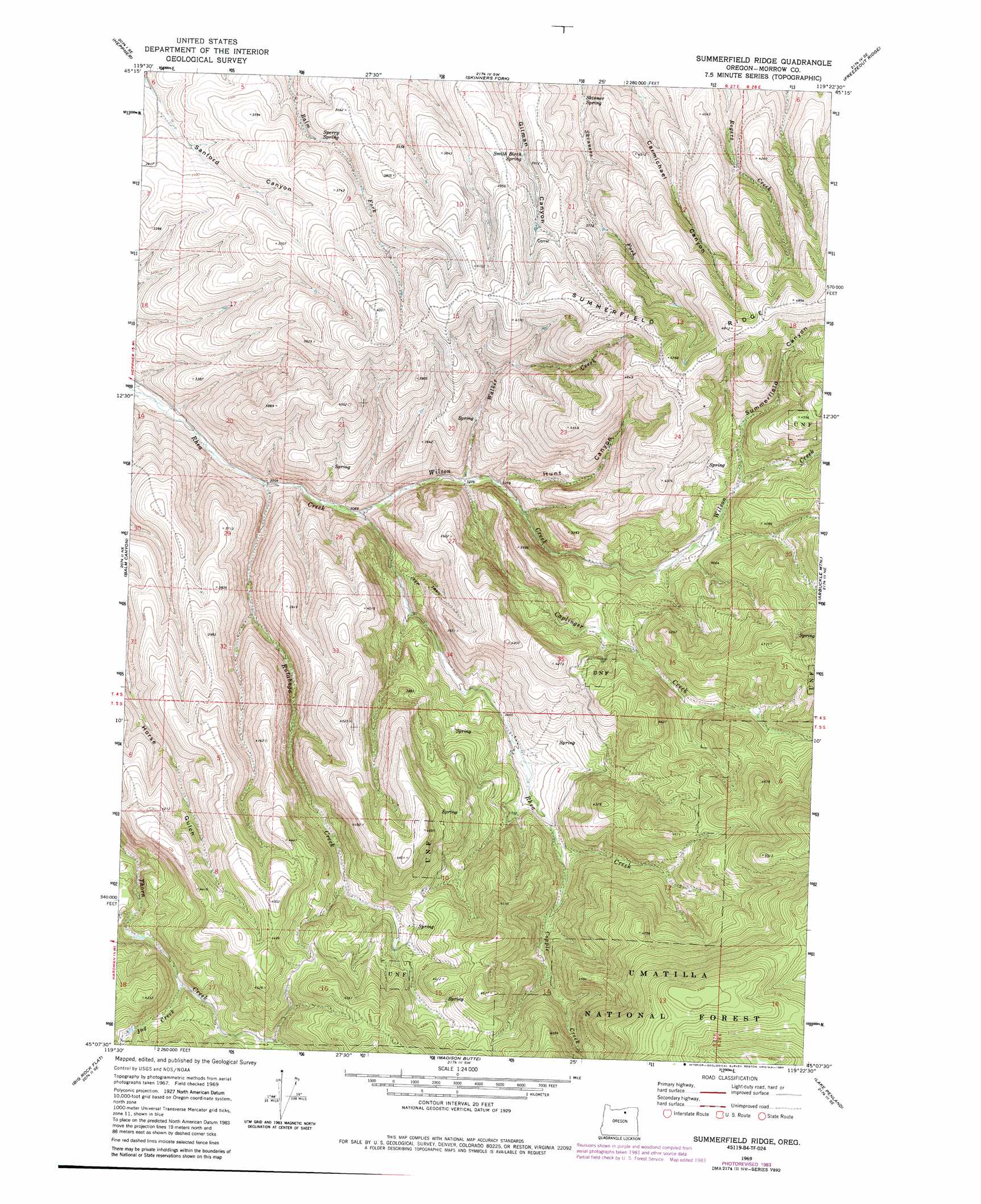
USGS Topo Quad 45119b4 - 1:24,000 scale
| Topo Map Name: | Summerfield Ridge |
| USGS Topo Quad ID: | 45119b4 |
| Print Size: | ca. 21 1/4" wide x 27" high |
| Southeast Coordinates: | 45.125° N latitude / 119.375° W longitude |
| Map Center Coordinates: | 45.1875° N latitude / 119.4375° W longitude |
| U.S. State: | OR |
| Filename: | o45119b4.jpg |
| Download Map JPG Image: | Summerfield Ridge topo map 1:24,000 scale |
| Map Type: | Topographic |
| Topo Series: | 7.5´ |
| Map Scale: | 1:24,000 |
| Source of Map Images: | United States Geological Survey (USGS) |
| Alternate Map Versions: |
Summerfield Ridge OR 1969, updated 1973 Download PDF Buy paper map Summerfield Ridge OR 1969, updated 1984 Download PDF Buy paper map Summerfield Ridge OR 1995, updated 1998 Download PDF Buy paper map Summerfield Ridge OR 2011 Download PDF Buy paper map Summerfield Ridge OR 2014 Download PDF Buy paper map |
| FStopo: | US Forest Service topo Summerfield Ridge is available: Download FStopo PDF Download FStopo TIF |
1:24,000 Topo Quads surrounding Summerfield Ridge
Lexington |
Swaggart Buttes |
Gleason Butte |
Lena |
Franklin Hill |
Ruggs |
Heppner |
Skinners Fork |
Freezeout Ridge |
Hoodlum Canyon |
Hardman |
Balm Canyon |
Summerfield Ridge |
Arbuckle Mountain |
Matlock Prairie |
Chapin Creek |
Big Rock Flat |
Madison Butte |
Lake Penland |
Thompson Flat |
Whitetail Butte |
Turner Mountain |
Johnny Cake Mountain |
Slickear Mountain |
Ritter |
> Back to 45119a1 at 1:100,000 scale
> Back to 45118a1 at 1:250,000 scale
> Back to U.S. Topo Maps home
Summerfield Ridge topo map: Gazetteer
Summerfield Ridge: Ridges
Summerfield Ridge elevation 1349m 4425′Summerfield Ridge: Springs
Rhea Spring elevation 1602m 5255′Skinner Spring elevation 1041m 3415′
Smith Birch Spring elevation 1133m 3717′
Sperry Spring elevation 1041m 3415′
Summerfield Ridge: Streams
Caplinger Creek elevation 984m 3228′Copple Creek elevation 1114m 3654′
Jug Creek elevation 1168m 3832′
Rutabaga Creek elevation 914m 2998′
Walker Creek elevation 981m 3218′
Wilson Creek elevation 942m 3090′
Summerfield Ridge: Valleys
Hunt Canyon elevation 999m 3277′Summerfield Canyon elevation 1168m 3832′
Thompson Canyon elevation 1050m 3444′
Summerfield Ridge digital topo map on disk
Buy this Summerfield Ridge topo map showing relief, roads, GPS coordinates and other geographical features, as a high-resolution digital map file on DVD: