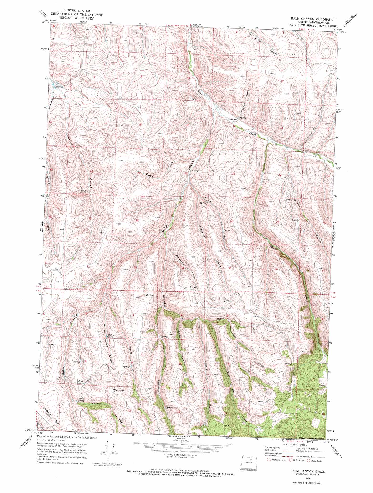
Balm Canyon Topo Map Oregon
To zoom in, hover over the map of Balm Canyon
USGS Topo Quad 45119b5 - 1:24,000 scale
| Topo Map Name: | Balm Canyon |
| USGS Topo Quad ID: | 45119b5 |
| Print Size: | ca. 21 1/4" wide x 27" high |
| Southeast Coordinates: | 45.125° N latitude / 119.5° W longitude |
| Map Center Coordinates: | 45.1875° N latitude / 119.5625° W longitude |
| U.S. State: | OR |
| Filename: | o45119b5.jpg |
| Download Map JPG Image: | Balm Canyon topo map 1:24,000 scale |
| Map Type: | Topographic |
| Topo Series: | 7.5´ |
| Map Scale: | 1:24,000 |
| Source of Map Images: | United States Geological Survey (USGS) |
| Alternate Map Versions: |
Balm Canyon OR 1969, updated 1973 Download PDF Buy paper map Balm Canyon OR 1969, updated 1973 Download PDF Buy paper map Balm Canyon OR 1995, updated 1998 Download PDF Buy paper map Balm Canyon OR 2011 Download PDF Buy paper map Balm Canyon OR 2014 Download PDF Buy paper map |
| FStopo: | US Forest Service topo Balm Canyon is available: Download FStopo PDF Download FStopo TIF |
1:24,000 Topo Quads surrounding Balm Canyon
Ione South |
Lexington |
Swaggart Buttes |
Gleason Butte |
Lena |
Eightmile |
Ruggs |
Heppner |
Skinners Fork |
Freezeout Ridge |
Buttermilk Canyon |
Hardman |
Balm Canyon |
Summerfield Ridge |
Arbuckle Mountain |
Lefevre Prairie |
Chapin Creek |
Big Rock Flat |
Madison Butte |
Lake Penland |
Collins Butte |
Whitetail Butte |
Turner Mountain |
Johnny Cake Mountain |
Slickear Mountain |
> Back to 45119a1 at 1:100,000 scale
> Back to 45118a1 at 1:250,000 scale
> Back to U.S. Topo Maps home
Balm Canyon topo map: Gazetteer
Balm Canyon: Springs
Lowen Spring elevation 1156m 3792′Saling Spring elevation 1207m 3959′
Willow Spring elevation 1102m 3615′
Balm Canyon: Streams
Gene Creek elevation 1087m 3566′Gravy Creek elevation 1000m 3280′
Hackman Creek elevation 980m 3215′
Houselog Creek elevation 919m 3015′
Rocky Creek elevation 1008m 3307′
Sperry Creek elevation 1035m 3395′
Thorn Creek elevation 832m 2729′
Three Rock Creek elevation 1049m 3441′
Wood Creek elevation 1142m 3746′
Balm Canyon: Summits
Warm Hill elevation 1296m 4251′Balm Canyon: Valleys
Balm Canyon elevation 815m 2673′Doug Canyon elevation 848m 2782′
Gilliam Canyon elevation 807m 2647′
Graveyard Canyon elevation 843m 2765′
Horse Gulch elevation 840m 2755′
Lunceford Canyon elevation 849m 2785′
Pine Hollow elevation 1144m 3753′
Ridgeway Canyon elevation 897m 2942′
Road Canyon elevation 866m 2841′
Waterfall Canyon elevation 930m 3051′
Willow Spring Canyon elevation 1007m 3303′
Balm Canyon digital topo map on disk
Buy this Balm Canyon topo map showing relief, roads, GPS coordinates and other geographical features, as a high-resolution digital map file on DVD: