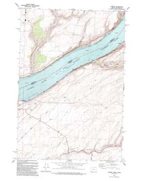
Juniper Topo Map Oregon
To zoom in, hover over the map of Juniper
USGS Topo Quad 45119h1 - 1:24,000 scale
| Topo Map Name: | Juniper |
| USGS Topo Quad ID: | 45119h1 |
| Print Size: | ca. 21 1/4" wide x 27" high |
| Southeast Coordinates: | 45.875° N latitude / 119° W longitude |
| Map Center Coordinates: | 45.9375° N latitude / 119.0625° W longitude |
| U.S. States: | OR, WA |
| Filename: | o45119h1.jpg |
| Download Map JPG Image: | Juniper topo map 1:24,000 scale |
| Map Type: | Topographic |
| Topo Series: | 7.5´ |
| Map Scale: | 1:24,000 |
| Source of Map Images: | United States Geological Survey (USGS) |
| Alternate Map Versions: |
Juniper OR 1962, updated 1963 Download PDF Buy paper map Juniper OR 1993 Download PDF Buy paper map Juniper OR 2011 Download PDF Buy paper map Juniper OR 2014 Download PDF Buy paper map |
1:24,000 Topo Quads surrounding Juniper
> Back to 45119e1 at 1:100,000 scale
> Back to 45118a1 at 1:250,000 scale
> Back to U.S. Topo Maps home
Juniper topo map: Gazetteer
Juniper: Areas
Tomar elevation 127m 416′Juniper: Islands
Switzler Island (historical) elevation 105m 344′Switzler Island (historical) elevation 105m 344′
Van Skinner Island elevation 129m 423′
Juniper: Parks
Sand Station Recreation Area elevation 109m 357′Juniper: Plains
Columbia Plateau elevation 213m 698′Juniper: Post Offices
Hawthorne Post Office (historical) elevation 105m 344′Juniper Post Office (historical) elevation 114m 374′
Juniper: Valleys
Juniper Canyon elevation 106m 347′South Fork Cold Springs Canyon elevation 250m 820′
Spaw Canyon elevation 112m 367′
Switzler Canyon elevation 105m 344′
Juniper digital topo map on disk
Buy this Juniper topo map showing relief, roads, GPS coordinates and other geographical features, as a high-resolution digital map file on DVD:


