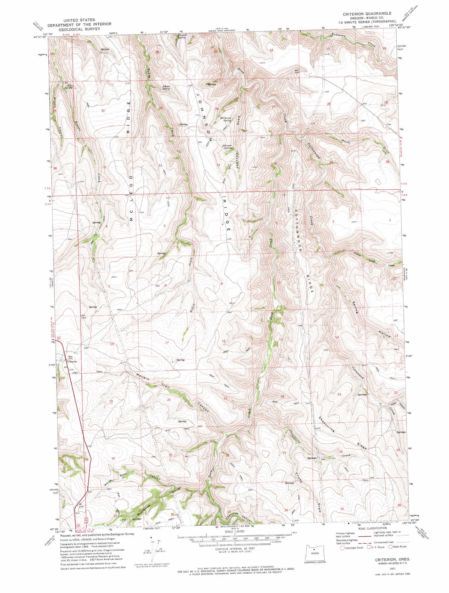
Criterion Topo Map Oregon
To zoom in, hover over the map of Criterion
USGS Topo Quad 45120a8 - 1:24,000 scale
| Topo Map Name: | Criterion |
| USGS Topo Quad ID: | 45120a8 |
| Print Size: | ca. 21 1/4" wide x 27" high |
| Southeast Coordinates: | 45° N latitude / 120.875° W longitude |
| Map Center Coordinates: | 45.0625° N latitude / 120.9375° W longitude |
| U.S. State: | OR |
| Filename: | o45120a8.jpg |
| Download Map JPG Image: | Criterion topo map 1:24,000 scale |
| Map Type: | Topographic |
| Topo Series: | 7.5´ |
| Map Scale: | 1:24,000 |
| Source of Map Images: | United States Geological Survey (USGS) |
| Alternate Map Versions: |
Criterion OR 1971, updated 1973 Download PDF Buy paper map Criterion OR 2011 Download PDF Buy paper map Criterion OR 2014 Download PDF Buy paper map |
1:24,000 Topo Quads surrounding Criterion
Postage Stamp Butte |
Sherars Bridge |
Sinamox |
Grass Valley |
Rosebush |
Tygh Valley |
Maupin |
Dead Dog Canyon |
Bronx Canyon |
Kent |
Maupin Sw |
Dant |
Criterion |
Shaniko |
Macken Canyon |
Mutton Mountain |
Kaskela |
Shaniko Junction |
Shaniko Summit |
Antelope |
Eagle Butte |
Gateway |
Willowdale |
Degner Canyon |
Donnybrook |
> Back to 45120a1 at 1:100,000 scale
> Back to 45120a1 at 1:250,000 scale
> Back to U.S. Topo Maps home
Criterion topo map: Gazetteer
Criterion: Populated Places
Criterion (historical) elevation 947m 3106′Criterion: Post Offices
Criterion Post Office (historical) elevation 947m 3106′Criterion: Ridges
Cottonwood Ridge elevation 838m 2749′Johnson Ridge elevation 821m 2693′
McLeod Ridge elevation 789m 2588′
Shoestring Ridge elevation 919m 3015′
Criterion: Springs
Adams Spring elevation 652m 2139′Fargher Spring elevation 608m 1994′
Horncrist Spring elevation 689m 2260′
Johnson Spring elevation 712m 2335′
Criterion: Streams
Birch Creek elevation 565m 1853′Cottonwood Creek elevation 544m 1784′
Ochoco Gulch Creek elevation 665m 2181′
Shoestring Creek elevation 716m 2349′
Criterion: Valleys
Boardtree Canyon elevation 782m 2565′Chandler Canyon elevation 797m 2614′
Coon Hollow elevation 813m 2667′
Johnson Draw elevation 506m 1660′
Maupin Trail Canyon elevation 746m 2447′
Middle Canyon elevation 542m 1778′
Sparks Gulch elevation 864m 2834′
Spring Hollow elevation 690m 2263′
Tricky Draw elevation 807m 2647′
White Door Canyon elevation 824m 2703′
Criterion digital topo map on disk
Buy this Criterion topo map showing relief, roads, GPS coordinates and other geographical features, as a high-resolution digital map file on DVD: