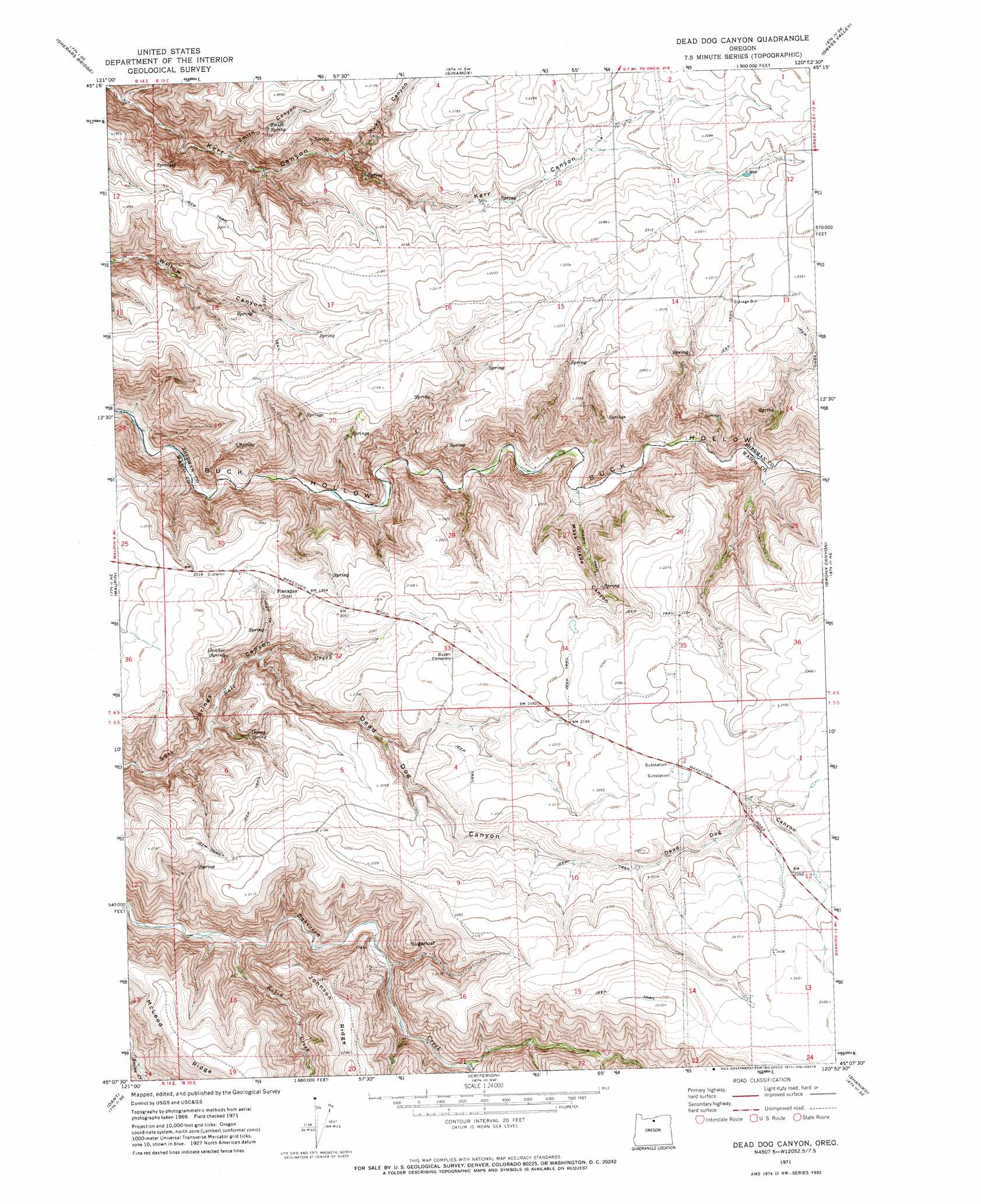
Dead Dog Canyon Topo Map Oregon
To zoom in, hover over the map of Dead Dog Canyon
USGS Topo Quad 45120b8 - 1:24,000 scale
| Topo Map Name: | Dead Dog Canyon |
| USGS Topo Quad ID: | 45120b8 |
| Print Size: | ca. 21 1/4" wide x 27" high |
| Southeast Coordinates: | 45.125° N latitude / 120.875° W longitude |
| Map Center Coordinates: | 45.1875° N latitude / 120.9375° W longitude |
| U.S. State: | OR |
| Filename: | o45120b8.jpg |
| Download Map JPG Image: | Dead Dog Canyon topo map 1:24,000 scale |
| Map Type: | Topographic |
| Topo Series: | 7.5´ |
| Map Scale: | 1:24,000 |
| Source of Map Images: | United States Geological Survey (USGS) |
| Alternate Map Versions: |
Dead Dog Canyon OR 1971, updated 1973 Download PDF Buy paper map Dead Dog Canyon OR 2011 Download PDF Buy paper map Dead Dog Canyon OR 2014 Download PDF Buy paper map |
1:24,000 Topo Quads surrounding Dead Dog Canyon
Dufur West |
Dufur East |
Summit Ridge |
Erskine |
Moro |
Postage Stamp Butte |
Sherars Bridge |
Sinamox |
Grass Valley |
Rosebush |
Tygh Valley |
Maupin |
Dead Dog Canyon |
Bronx Canyon |
Kent |
Maupin Sw |
Dant |
Criterion |
Shaniko |
Macken Canyon |
Mutton Mountain |
Kaskela |
Shaniko Junction |
Shaniko Summit |
Antelope |
> Back to 45120a1 at 1:100,000 scale
> Back to 45120a1 at 1:250,000 scale
> Back to U.S. Topo Maps home
Dead Dog Canyon topo map: Gazetteer
Dead Dog Canyon: Post Offices
Flanagan Post Office (historical) elevation 600m 1968′Dead Dog Canyon: Springs
Denny Spring elevation 508m 1666′Gamber Spring elevation 554m 1817′
Smith Spring elevation 556m 1824′
Dead Dog Canyon: Streams
Deep Creek elevation 459m 1505′Robin Creek elevation 380m 1246′
Dead Dog Canyon: Summits
Sugarloaf elevation 643m 2109′Dead Dog Canyon: Valleys
Dead Dog Canyon elevation 470m 1541′Kuks Canyon elevation 495m 1624′
Mays Grade Canyon elevation 430m 1410′
Smith Canyon elevation 401m 1315′
Dead Dog Canyon digital topo map on disk
Buy this Dead Dog Canyon topo map showing relief, roads, GPS coordinates and other geographical features, as a high-resolution digital map file on DVD: