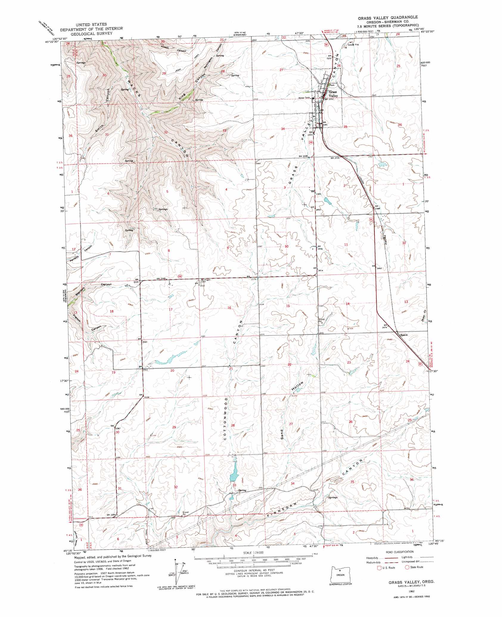
Grass Valley Topo Map Oregon
To zoom in, hover over the map of Grass Valley
USGS Topo Quad 45120c7 - 1:24,000 scale
| Topo Map Name: | Grass Valley |
| USGS Topo Quad ID: | 45120c7 |
| Print Size: | ca. 21 1/4" wide x 27" high |
| Southeast Coordinates: | 45.25° N latitude / 120.75° W longitude |
| Map Center Coordinates: | 45.3125° N latitude / 120.8125° W longitude |
| U.S. State: | OR |
| Filename: | o45120c7.jpg |
| Download Map JPG Image: | Grass Valley topo map 1:24,000 scale |
| Map Type: | Topographic |
| Topo Series: | 7.5´ |
| Map Scale: | 1:24,000 |
| Source of Map Images: | United States Geological Survey (USGS) |
| Alternate Map Versions: |
Grass Valley OR 1962, updated 1964 Download PDF Buy paper map Grass Valley OR 2011 Download PDF Buy paper map Grass Valley OR 2014 Download PDF Buy paper map |
1:24,000 Topo Quads surrounding Grass Valley
Petersburg |
Emerson |
Locust Grove |
Wasco |
Klondike |
Dufur East |
Summit Ridge |
Erskine |
Moro |
Harmony |
Sherars Bridge |
Sinamox |
Grass Valley |
Rosebush |
Indian Cove |
Maupin |
Dead Dog Canyon |
Bronx Canyon |
Kent |
Horseshoe Bend |
Dant |
Criterion |
Shaniko |
Macken Canyon |
Bath Canyon |
> Back to 45120a1 at 1:100,000 scale
> Back to 45120a1 at 1:250,000 scale
> Back to U.S. Topo Maps home
Grass Valley topo map: Gazetteer
Grass Valley: Dams
Buether Dam elevation 669m 2194′Grass Valley: Parks
Grass Valley City Park elevation 685m 2247′Grass Valley: Populated Places
Grass Valley elevation 688m 2257′Grass Valley: Post Offices
Grass Valley Post Office elevation 688m 2257′Grass Valley: Reservoirs
Buether Reservoir elevation 681m 2234′Grass Valley: Streams
Draw Creek elevation 739m 2424′Grass Valley: Valleys
Cottonwood Canyon elevation 615m 2017′Holmes Canyon elevation 600m 1968′
King Canyon elevation 311m 1020′
Remington Canyon elevation 558m 1830′
Sand Hollow elevation 619m 2030′
Smith Canyon elevation 284m 931′
Grass Valley digital topo map on disk
Buy this Grass Valley topo map showing relief, roads, GPS coordinates and other geographical features, as a high-resolution digital map file on DVD: