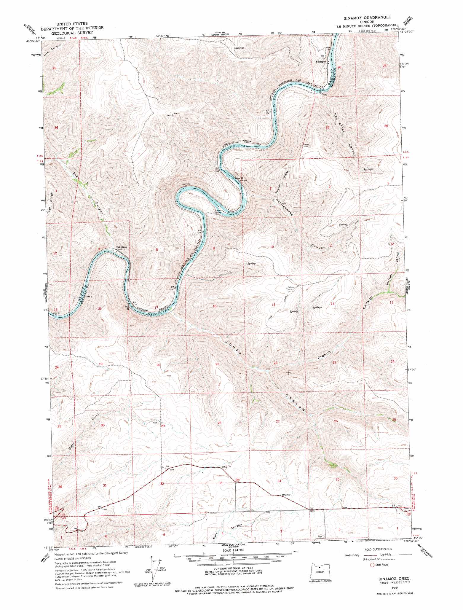
Sinamox Topo Map Oregon
To zoom in, hover over the map of Sinamox
USGS Topo Quad 45120c8 - 1:24,000 scale
| Topo Map Name: | Sinamox |
| USGS Topo Quad ID: | 45120c8 |
| Print Size: | ca. 21 1/4" wide x 27" high |
| Southeast Coordinates: | 45.25° N latitude / 120.875° W longitude |
| Map Center Coordinates: | 45.3125° N latitude / 120.9375° W longitude |
| U.S. State: | OR |
| Filename: | o45120c8.jpg |
| Download Map JPG Image: | Sinamox topo map 1:24,000 scale |
| Map Type: | Topographic |
| Topo Series: | 7.5´ |
| Map Scale: | 1:24,000 |
| Source of Map Images: | United States Geological Survey (USGS) |
| Alternate Map Versions: |
Sinamox OR 1962, updated 1964 Download PDF Buy paper map Sinamox OR 1962, updated 1978 Download PDF Buy paper map Sinamox OR 2011 Download PDF Buy paper map Sinamox OR 2014 Download PDF Buy paper map |
1:24,000 Topo Quads surrounding Sinamox
The Dalles South |
Petersburg |
Emerson |
Locust Grove |
Wasco |
Dufur West |
Dufur East |
Summit Ridge |
Erskine |
Moro |
Postage Stamp Butte |
Sherars Bridge |
Sinamox |
Grass Valley |
Rosebush |
Tygh Valley |
Maupin |
Dead Dog Canyon |
Bronx Canyon |
Kent |
Maupin Sw |
Dant |
Criterion |
Shaniko |
Macken Canyon |
> Back to 45120a1 at 1:100,000 scale
> Back to 45120a1 at 1:250,000 scale
> Back to U.S. Topo Maps home
Sinamox topo map: Gazetteer
Sinamox: Islands
Cedar Island elevation 166m 544′Sinamox: Parks
Beavertail Recreation Site elevation 170m 557′Sinamox: Post Offices
Sinamox Post Office (historical) elevation 163m 534′Sinamox: Valleys
Box Elder Canyon elevation 158m 518′Ferry Canyon elevation 146m 479′
French Canyon elevation 283m 928′
Gert Canyon elevation 233m 764′
Jones Canyon elevation 183m 600′
Oak Canyon elevation 193m 633′
Perrault Canyon elevation 517m 1696′
Peterson Canyon elevation 253m 830′
Rattlesnake Canyon elevation 162m 531′
Stanton Canyon elevation 544m 1784′
Station Canyon elevation 558m 1830′
Sinamox digital topo map on disk
Buy this Sinamox topo map showing relief, roads, GPS coordinates and other geographical features, as a high-resolution digital map file on DVD: