Biggs Junction Topo Map Washington
To zoom in, hover over the map of Biggs Junction
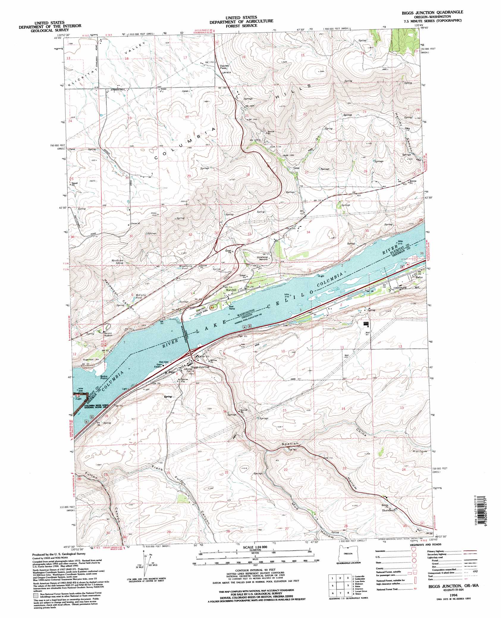
USGS Topo Quad 45120f7 - 1:24,000 scale
| Topo Map Name: | Biggs Junction |
| USGS Topo Quad ID: | 45120f7 |
| Print Size: | ca. 21 1/4" wide x 27" high |
| Southeast Coordinates: | 45.625° N latitude / 120.75° W longitude |
| Map Center Coordinates: | 45.6875° N latitude / 120.8125° W longitude |
| U.S. States: | WA, OR |
| Filename: | o45120f7.jpg |
| Download Map JPG Image: | Biggs Junction topo map 1:24,000 scale |
| Map Type: | Topographic |
| Topo Series: | 7.5´ |
| Map Scale: | 1:24,000 |
| Source of Map Images: | United States Geological Survey (USGS) |
| Alternate Map Versions: |
Biggs Junction OR 1977, updated 1978 Download PDF Buy paper map Biggs Junction OR 1994, updated 1995 Download PDF Buy paper map Biggs Junction OR 2011 Download PDF Buy paper map Biggs Junction OR 2014 Download PDF Buy paper map |
| FStopo: | US Forest Service topo Biggs Junction is available: Download FStopo PDF Download FStopo TIF |
1:24,000 Topo Quads surrounding Biggs Junction
Grayback Mountain |
White Pine Buttes |
Indian Rock |
Status Pass |
Lone Pine Butte |
Wahkiacus |
Centerville |
Goldendale |
Luna Butte |
Luna Gulch |
Stacker Butte |
Wishram |
Biggs Junction |
Rufus |
Quinton |
Petersburg |
Emerson |
Locust Grove |
Wasco |
Klondike |
Dufur East |
Summit Ridge |
Erskine |
Moro |
Harmony |
> Back to 45120e1 at 1:100,000 scale
> Back to 45120a1 at 1:250,000 scale
> Back to U.S. Topo Maps home
Biggs Junction topo map: Gazetteer
Biggs Junction: Bridges
Sam Hill Memorial Bridge elevation 50m 164′Biggs Junction: Capes
Bobs Point elevation 52m 170′Biggs Junction: Channels
Hells Gate Channel Range B elevation 50m 164′Biggs Junction: Gaps
Davies Pass elevation 533m 1748′Biggs Junction: Lakes
McCarty Pond elevation 261m 856′Wheelhouse Pond elevation 266m 872′
Biggs Junction: Parks
Maryhill State Park elevation 55m 180′Stonehenge Memorial elevation 171m 561′
Biggs Junction: Populated Places
Biggs Junction elevation 68m 223′Maryhill elevation 57m 187′
Biggs Junction: Post Offices
Biggs Post Office (historical) elevation 67m 219′Grant Post Office (historical) elevation 54m 177′
Maryhill Post Office (historical) elevation 57m 187′
Thornberry Post Office (historical) elevation 285m 935′
Villard Post Office (historical) elevation 51m 167′
Biggs Junction: Ranges
Columbia Hills elevation 812m 2664′Biggs Junction: Springs
Henderson Spring elevation 455m 1492′Biggs Junction: Streams
China Hollow Creek elevation 222m 728′Biggs Junction: Summits
Sugarloaf elevation 111m 364′Biggs Junction: Valleys
China Hollow elevation 208m 682′Frank Fulton Canyon elevation 116m 380′
Gerking Canyon elevation 50m 164′
Henderson Canyon elevation 63m 206′
Mud Hollow elevation 151m 495′
Spanish Hollow elevation 58m 190′
Biggs Junction digital topo map on disk
Buy this Biggs Junction topo map showing relief, roads, GPS coordinates and other geographical features, as a high-resolution digital map file on DVD: